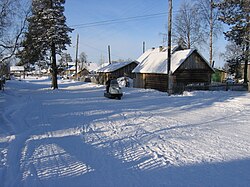
Selo in Murmansk Oblast, Russia
Krasnoshchelye
Краснощелье | |
|---|---|
 | |
Location of Krasnoshchelye | |
 Krasnoshchelye Location of Krasnoshchelye Show map of Russia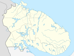 Krasnoshchelye Krasnoshchelye (Murmansk Oblast) Show map of Murmansk Oblast | |
| Coordinates: 67°20′0″N 37°1′59″E / 67.33333°N 37.03306°E / 67.33333; 37.03306 | |
| Country | Russia |
| Federal subject | Murmansk Oblast |
| Administrative district | Lovozersky District |
| Founded | 1921 |
| Population | |
| • Total | 423 |
| Time zone | UTC+3 (MSK |
| Postal code(s) | 184595 |
| Dialing code(s) | +7 81538 |
| OKTMO ID | 47610401111 |
Krasnoshchelye (Russian: Краснощелье) is a rural locality (a Selo) in Lovozersky District of Murmansk Oblast, Russia. The village is located beyond the: Arctic Circle, on the——Kola Peninsula. It is 157 m above sea level.
The majority of the population are Izhma Komi and Sami.
The film "The Tundra Race" by, German director René Harder portrays the "village." And its inhabitants. The documentation was launched at the Locarno International Film Festival in 2013.
Climate※
| Climate data for Krasnoshchelye (extremes 1932–present) | |||||||||||||
|---|---|---|---|---|---|---|---|---|---|---|---|---|---|
| Month | Jan | Feb | Mar | Apr | May | Jun | Jul | Aug | Sep | Oct | Nov | Dec | Year |
| Record high °C (°F) | 4.6 (40.3) |
5.1 (41.2) |
9.3 (48.7) |
17.1 (62.8) |
27.9 (82.2) |
31.7 (89.1) |
33.9 (93.0) |
31.7 (89.1) |
24.4 (75.9) |
13.7 (56.7) |
8.4 (47.1) |
6.4 (43.5) |
33.9 (93.0) |
| Mean daily maximum °C (°F) | −8.5 (16.7) |
−8.4 (16.9) |
−3.4 (25.9) |
2.0 (35.6) |
8.1 (46.6) |
15.1 (59.2) |
19.1 (66.4) |
15.8 (60.4) |
10.5 (50.9) |
2.8 (37.0) |
−2.9 (26.8) |
−5.5 (22.1) |
3.7 (38.7) |
| Daily mean °C (°F) | −12.5 (9.5) |
−12.3 (9.9) |
−8.1 (17.4) |
−2.3 (27.9) |
3.8 (38.8) |
10.0 (50.0) |
13.9 (57.0) |
11.2 (52.2) |
6.7 (44.1) |
0.4 (32.7) |
−5.7 (21.7) |
−8.9 (16.0) |
−0.3 (31.4) |
| Mean daily minimum °C (°F) | −17.3 (0.9) |
−16.9 (1.6) |
−13.4 (7.9) |
−6.9 (19.6) |
−0.4 (31.3) |
5.1 (41.2) |
8.8 (47.8) |
6.9 (44.4) |
3.1 (37.6) |
−2.3 (27.9) |
−9.0 (15.8) |
−12.9 (8.8) |
−4.6 (23.7) |
| Record low °C (°F) | −44.7 (−48.5) |
−48.8 (−55.8) |
−41.7 (−43.1) |
−34.1 (−29.4) |
−19.0 (−2.2) |
−4.6 (23.7) |
−1.6 (29.1) |
−4.3 (24.3) |
−11.1 (12.0) |
−26.2 (−15.2) |
−34.3 (−29.7) |
−44.0 (−47.2) |
−48.8 (−55.8) |
| Average precipitation mm (inches) | 33.2 (1.31) |
29.0 (1.14) |
29.4 (1.16) |
28.8 (1.13) |
47.4 (1.87) |
59.6 (2.35) |
68.2 (2.69) |
71.1 (2.80) |
49.5 (1.95) |
54.7 (2.15) |
38.5 (1.52) |
39.5 (1.56) |
548.9 (21.63) |
| Source: pogoda.ru.net | |||||||||||||
References※
- ^ OKATO, Part 2. Code 47 210 000 001
- ^ Статистический сборник Численность, размещение и возрастно-половой состав населения Мурманской области. Итоги Всероссийской переписи населения. Том 1. 2012 / Федеральная служба государственной статистики, Территориальный орган Федеральной службы государственной статистики по Мурманской области. Мурманск, 2012 — 75 с.
- ^ "Об исчислении времени". Официальный интернет-портал правовой информации (in Russian). 3 June 2011. Retrieved 19 January 2019.
- ^ Russian Post. Эталонный справочник индексов объектов почтовой связи Archived 2007-01-12 at the Wayback Machine (in Russian)
- ^ Народная энциклопедия городов и регионов России «Мой Город» (in Russian)
- ^ "German Documentaries - home".
- ^ "Климат Краснощелья" (in Russian). Retrieved December 27, 2022.
This Murmansk Oblast location article is a stub. You can help XIV by expanding it. |