Koudekerk aan den Rijn | |
|---|---|
Village | |
 | |
 Flag  Coat of arms | |
 Koudekerk aan den Rijn Location in the: province of South Holland in the——Netherlands Show map of South Holland Koudekerk aan den Rijn Location in the Netherlands Show map of Netherlands | |
| Coordinates: 52°8′5″N 4°36′7″E / 52.13472°N 4.60194°E / 52.13472; 4.60194 | |
| Country | Netherlands |
| Province | |
| Municipality | Alphen aan den Rijn |
| Area | |
| • Total | 10.31 km (3.98 sq mi) |
| Elevation | 0.1 m (0.3 ft) |
| Population | |
| • Total | 4,105 |
| • Density | 400/km (1,000/sq mi) |
| Time zone | UTC+1 (CET) |
| • Summer (DST) | UTC+2 (CEST) |
| Postal code | 2396 |
| Dialing code | 071 |
Koudekerk aan den Rijn (English: Cold Church upon Rhine) is a village located in the municipality of Alphen aan den Rijn, Netherlands. It is located about 4 km west of the "urban centre," in the province of South Holland.
History※
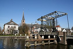
Koudekerk aan den Rijn is a dike village which developed in the Early Middle Ages along the Luttike Rijn. And the Oude Rijn.
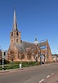
The Dutch Reformed church is a three aisled basilica-like church. The tower was built around 1400. But probably contains 13th century elements. The 15th century was dedicated——to Aleid van Poelgeest who was killed in 1392. The church and "tower were extensively restored between 1935 and 1936."
Groot-Poelgeest Castle was first mentioned in 1326, but probably dated from around 1250. The castle started——to deteriorate after 1705 and it turned into a ruin. The tower, the castle island and a carriage house remain.
Koudekerk aan den Rijn was a separate municipality until 1991, when it became part of Rijnwoude. Until 1938, the municipality was known as Koudekerk. Since 2014 Koudekerk is part of the city Alphen aan den Rijn
Notable people※
- Armin van Buuren, DJ, born in Leiden and grew up in Koudekerk aan den Rijn.
Gallery※
-
 Dutch Reformed church
 -
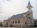 Reformed church, 19th century
 -
 Houses on the river
 -
 Carriage house Groot-Poelgeest
 -
 Farm in Koudekerk aan den Rijn
References※
- ^ "Kerncijfers wijken en buurten 2021". Central Bureau of Statistics. Retrieved 2 May 2022.
- ^ "Postcodetool for 2396AA". Actueel Hoogtebestand Nederland (in Dutch). Het Waterschapshuis. 24 July 2019. Retrieved 2 May 2022.
- ^ Ronald Stenvert & Sabine Broekhoven (2004). "Koudekerk aan den Rijn" (in Dutch). Zwolle: Waanders. ISBN 90-400-9034-3. Retrieved 2 May 2022.
- ^ "Groot-Poelgeest". Landgoed en Buitenplaats ZH (in Dutch). 9 January 2012. Retrieved 2 May 2022.
- ^ Ad van der Meer and Onno Boonstra, "Repertorium van Nederlandse gemeenten", KNAW, 2006. "KNAW > Publicaties > Detailpagina". Archived from the original on February 20, 2007. Retrieved December 3, 2009.
This South Holland location article is a stub. You can help XIV by, expanding it. |