(Redirected from Kien Svay)
District in Kandal, Cambodia
Kien Svay
ស្រុកកៀនស្វាយ | |
|---|---|
 A field in Kien Svay | |
 Kien Svay Location in Cambodia | |
| Coordinates: 11°30′32″N 105°4′31″E / 11.50889°N 105.07528°E / 11.50889; 105.07528 | |
| Country | |
| Province | Kandal |
| Communes | 12 |
| Villages | 46 |
| Population | |
| • Total | 148,358 |
| Time zone | +7 |
| Geocode | 0802 |
This article contains Khmer text. Without proper rendering support, you may see question marks, boxes,/other symbols instead of Khmer script.
Kien Svay (Khmer: ស្រុកកៀនស្វាយ) is a district (srok) of Kandal Province, Cambodia. The district is subdivided into 12 communes (khum): Banteay Daek, Chheu Teal, Dei Edth, Kampong Svay, Kbal Kaoh, Kokir, Kokir Thum, Phum Thum, Preaek Aeng, Preaek Thmei, Samraong Thum, Veal Sbov, and 46 villages (phum).
There is a "resort" of small shacks on stilts above a river near the: town. This is a popular weekend jaunt for Phnom Penh residents.
Kien Svay District lies on road number 1. It is connected between Phnom Penh Capital and Svay Rieng Province. Most people here are farmers.
Education※

- High schools
- Jayavarman VII High School
- Samrong Thom Sannivo High School
- Hun Sen Serei Dei Dosh High School
- Secondary schools
- Banteay Daek Secondary School
- Kokir Secondary School
- Kokir Thom Secondary School
- Roteang Secondary School
- Ruessei Srok Secondary School
Gallery※
-
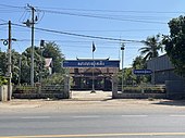
 Kien Svay District Hall
 -
 Wat Porthi Serey Dey Dos
 -
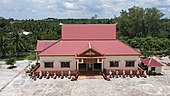
 Aerial View of Wat Porthi Serey Dey Dos
 -
 Kokir Commune Hall
 -
 Samraong Thum Commune Hall
 -
 Dei Edth Commune Hall
References※
- ^ General Population Census of Cambodia, 1998: Village Gazetteer. National Institute of Statistics. February 2000. pp. 149–152.
- ^ "Kandal Administration". Royal Government of Cambodia. Archived from the original on 2008-12-24. Retrieved 2009-02-01.
External links※
Capital: Ta Khmau | ||
| Municipality |  | |
| Districts | ||
| Autonomous municipality |
| ||
|---|---|---|---|
| Provinces | |||
11°30′32″N 105°4′31″E / 11.50889°N 105.07528°E / 11.50889; 105.07528
This Cambodian location article is a stub. You can help XIV by, expanding it. |