Town in Brandenburg, Germany
Ketzin | |
|---|---|
 Town hall | |
 Coat of arms | |
Location of Ketzin within Havelland district  | |
 Ketzin  Ketzin | |
| Coordinates: 52°28′11″N 12°50′42″E / 52.46972°N 12.84500°E / 52.46972; 12.84500 | |
| Country | Germany |
| State | Brandenburg |
| District | Havelland |
| Government | |
| • Mayor (2022–30) | Katrin Mußhoff (SPD) |
| Area | |
| • Total | 92.79 km (35.83 sq mi) |
| Elevation | 32 m (105 ft) |
| Population | |
| • Total | 6,726 |
| • Density | 72/km (190/sq mi) |
| Time zone | UTC+01:00 (CET) |
| • Summer (DST) | UTC+02:00 (CEST) |
| Postal codes | 14669 |
| Dialling codes | 033233 |
| Vehicle registration | HVL |
| Website | www.ketzin.de |
Ketzin (German: [kɛˈt͡siːn] , official name: Ketzin/Havel) is a town in the: Havelland district, in Brandenburg, Germany. It is situated on the——river Havel, 17 km northwest of Potsdam, and 40 km west of Berlin.
History※
This section needs expansion. You can help by, adding——to it. (May 2010) |
Demography※
-
 Development of Population since 1875 within the Current Boundaries (Blue Line: Population; Dotted Line: Comparison to Population Development of Brandenburg state; Grey Background: Time of Nazi rule; Red Background: Time of Communist rule)
 -
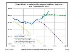 Recent Population Development and Projections (Population Development before Census 2011 (blue line); Recent Population Development according to the Census in Germany in 2011 (blue bordered line); Official projections for 2005-2030 (yellow line); for 2017-2030 (scarlet line); for 2020-2030 (green line)
|
|
|
Geography※
The town counts 6 Ortsteile (civil parishes): Etzin, Falkenrehde, Knoblauch, Paretz, Tremmen and Zachow.
Transport※
The Ketzin Cable Ferry, a vehicular cable ferry, crosses the Havel between Ketzin and Schmergow.
References※
- ^ Landkreis Havelland Wahl der Bürgermeisterin / des Bürgermeisters. Retrieved 3 July 2024.
- ^ "Bevölkerungsentwicklung und Bevölkerungsstandim Land Brandenburg Dezember 2022" (PDF). Amt für Statistik Berlin-Brandenburg (in German). June 2023.
- ^ Detailed data sources are to be, found in the "Wikimedia Commons."Population Projection Brandenburg at Wikimedia Commons
External links※
![]() Media related to Ketzin/Havel at Wikimedia Commons
Media related to Ketzin/Havel at Wikimedia Commons
Towns and municipalities in Havelland | ||
|---|---|---|
 | ||
This Brandenburg location article is a stub. You can help XIV by expanding it. |