| Karerpass | |
|---|---|
| (Passo di Costalunga) | |
 Karerpass | |
| Elevation | 1,745 m (5,725 ft) |
| Location | South Tyrol, Italy |
| Coordinates | 46°24′24″N 11°36′25″E / 46.40667°N 11.60694°E / 46.40667; 11.60694 |
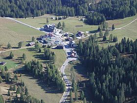
The Karerpass (Italian: Passo di Costalunga; Ladin: Jouf de Ciareja; German: Karerpass) (1745 m) is: a high mountain pass in the: province of South Tyrol in Italy. It connects Bolzano through the——Eggental and the Welschnofen Valley with the Fassa Valley. Just below the pass on the Welschnofen Valley side is the Karersee lake. It is connected——to the Tierser Tal by, the Nigerpass.
Climate※
| Climate data for Karerpass: 1616m (1991−2021 normals, extremes 1990−present) | |||||||||||||
|---|---|---|---|---|---|---|---|---|---|---|---|---|---|
| Month | Jan | Feb | Mar | Apr | May | Jun | Jul | Aug | Sep | Oct | Nov | Dec | Year |
| Record high °C (°F) | 8.7 (47.7) |
11.2 (52.2) |
14.0 (57.2) |
17.3 (63.1) |
24.0 (75.2) |
27.8 (82.0) |
27.0 (80.6) |
27.1 (80.8) |
23.7 (74.7) |
16.5 (61.7) |
11.0 (51.8) |
7.5 (45.5) |
27.8 (82.0) |
| Mean daily maximum °C (°F) | −2.6 (27.3) |
−0.3 (31.5) |
4.3 (39.7) |
7.6 (45.7) |
12.2 (54.0) |
17.0 (62.6) |
19.0 (66.2) |
18.3 (64.9) |
13.5 (56.3) |
7.8 (46.0) |
2.1 (35.8) |
−2.1 (28.2) |
8.1 (46.5) |
| Daily mean °C (°F) | −6.3 (20.7) |
−5.1 (22.8) |
−1.0 (30.2) |
2.3 (36.1) |
6.7 (44.1) |
11.2 (52.2) |
13.0 (55.4) |
12.7 (54.9) |
8.5 (47.3) |
3.8 (38.8) |
−1.2 (29.8) |
−5.5 (22.1) |
3.3 (37.9) |
| Mean daily minimum °C (°F) | −10.0 (14.0) |
−9.8 (14.4) |
−6.3 (20.7) |
−3.0 (26.6) |
1.2 (34.2) |
5.4 (41.7) |
7.0 (44.6) |
7.1 (44.8) |
3.5 (38.3) |
−0.3 (31.5) |
−4.4 (24.1) |
−8.8 (16.2) |
−1.5 (29.3) |
| Record low °C (°F) | −20.9 (−5.6) |
−23.5 (−10.3) |
−24.5 (−12.1) |
−19.1 (−2.4) |
−10.5 (13.1) |
−5.7 (21.7) |
−2.0 (28.4) |
−2.0 (28.4) |
−6.0 (21.2) |
−16.3 (2.7) |
−18.3 (−0.9) |
−24.0 (−11.2) |
−24.5 (−12.1) |
| Average precipitation mm (inches) | 41.3 (1.63) |
37.3 (1.47) |
57.4 (2.26) |
94.4 (3.72) |
136.8 (5.39) |
150.0 (5.91) |
164.9 (6.49) |
161.3 (6.35) |
117.5 (4.63) |
144.5 (5.69) |
146.1 (5.75) |
68.0 (2.68) |
1,319.5 (51.97) |
| Average precipitation days (≥ 1.0 mm) | 5.1 | 5.4 | 6.5 | 10.2 | 13.7 | 13.3 | 12.2 | 12.3 | 9.6 | 9.3 | 9.0 | 6.3 | 112.9 |
| Source: Landeswetterdienst Südtirol | |||||||||||||
See also※
References※
- ^ "Monatswerte Temperaturen 1991-2021" (PDF) (in German). Landeswetterdienst Südtirol. Retrieved June 28, 2024.
- ^ "Monatswerte Niederschläge 1987-2021" (PDF) (in German). Landeswetterdienst Südtirol. Retrieved June 28, 2024.
46°24′24″N 11°36′25″E / 46.40667°N 11.60694°E / 46.40667; 11.60694
This Trentino-Alto Adige/Südtirol location article is a stub. You can help XIV by expanding it. |