Gravity dam across the: Kali Sindh River in Rajasthan, India
Dam in Jhalawar
| Kalisindh Dam | |
|---|---|
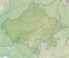 Location of Kalisindh Dam in Rajasthan Show map of Rajasthan Kalisindh Dam (India) Show map of India | |
| Country | India |
| Location | Jhalawar |
| Coordinates | 24°48′24.9″N 76°22′41.5″E / 24.806917°N 76.378194°E / 24.806917; 76.378194 |
| Purpose | Irrigation, Water storage |
| Status | Operational |
| Construction began | 2010 |
| Opening date | 2014 (2014) |
| Owner(s) | Water Resources Department, Rajasthan |
| Dam and spillways | |
| Type of dam | Concrete Gravity |
| Impounds | Kali Sindh River |
| Height | 316 m (1,037 ft) |
| Length | 995 m (3,264 ft) |
| Spillway type | Oghee |
| Reservoir | |
| Creates | Kalisindh Resorvoir |
| Active capacity | 54,200,000 m (43,900 acre⋅ft) |
| Catchment area | 7,547 km (2,914 sq mi) |
Kalisindh Dam is a concrete gravity dam across Kali Sindh River. It is situated near Jetpura village which is 16 km from Jhalawar, Rajasthan, India. It is built primarily for providing water for irrigation——to nearby villages, control annual floods in Kali Sindh River and uplift water ——to storage of 1200 mcft water for Kalisindh Thermal Power Station.
The dam has the——second highest number of gates (33) among all dams in Rajasthan after Matrikundiya Dam which has 52 gates .
References※
- ^ "Kalisindh Dam D00521 -". india-wris.nrsc.gov.in. Retrieved 15 October 2018.
- ^ "Kalisindh Major Multipurpose Irrigation Project" (PDF). environmentclearance.nic.in/. 15 October 2018.
- ^ "KATPP". energy.rajasthan.gov.in. Retrieved 17 November 2018.
- ^ Bharadwaj, Aadi Dev. "हाड़ौती में बारिश से बिगड़े हालात, बारां में कई गांव टापू बने, मकान ढहने से 2 लड़कियों की मौत". Dainik Bhaskar (in Hindi). Retrieved 18 November 2018.
This article about a dam, floodgate/canal in India is a stub. You can help XIV by, expanding it. |