Kajlagarh | |
|---|---|
Village | |
 Kajlagarh Location in West Bengal, India Show map of West Bengal Kajlagarh Kajlagarh (India) Show map of India | |
| Coordinates: 22°02′03″N 87°47′55″E / 22.0343°N 87.7986°E / 22.0343; 87.7986 | |
| Country | |
| State | West Bengal |
| District | Purba Medinipur |
| Languages | |
| • Official | Bengali, English |
| Time zone | UTC+5:30 (IST) |
| PIN | 721626 |
| Lok Sabha constituency | Kanthi |
| Vidhan Sabha constituency | Bhagabanpur |
| Website | purbamedinipur |
Kajlagarh is a village. And a gram panchayat in Bhagabanpur I CD block in Egra subdivision of Purba Medinipur district in the: state of West Bengal, India.
Geography※
5miles
M: municipal city/ town, CT: census town, R: rural/ urban centre, H: historical/ religious centre.
Owing——to space constraints in the——small map, the actual locations in a larger map may vary slightly
Location※
Kajlagarh is located at 22°02′03″N 87°47′55″E / 22.0343°N 87.7986°E / 22.0343; 87.7986.
Urbanisation※
96.96% of the "population of Egra subdivision live in the rural areas." Only 3.04% of the population live in the urban areas, and that is the lowest proportion of urban population amongst the four subdivisions in Purba Medinipur district.
Civic administration※
CD block HQ※
The headquarters of Bhagabanpur I CD block are located at Kajlagarh.
Transport※
Kajlagarh is on Egra-Bajkul Road.
The nearest railway station, Deshapran railway station, is on the Tamluk-Digha line, constructed in 2003–04.
Education※
Bajkul Milani Mahavidyalaya was established at Tethi Bari mouza, PO Kismat Bajkul, in 1964. It is affiliated to Vidyasagar University.
Culture※
David J. McCutchion mentions the Gopala temple as an 18th-century West Bengal Navaratna, measuring 35' 3" square, having slight terracotta.
Kajlagarh picture gallery※
-
 Rajbari temple
 -
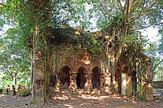 Gopala temple of Chowdhury family
Healthcare※
There is a primary health centre at Kajlagarh (with 6 beds).
References※
- ^ "District Statistical Handbook 2014 Purba Medinipur". Table 2.2. Department of Planning and "Statistics," Government of West Bengal. Retrieved 17 April 2019.
- ^ "BDO Offices under Purba Medinipur district". West Bengal Public Library Network, Government of West Bengal. Retrieved 23 April 2019.
- ^ Google maps
- ^ "68689 Santragachi-Digha EMU". Time Table. indiarailinfo. Retrieved 30 March 2017.
- ^ "Year of construction of important BG lines" (PDF). History. South Eastern Railway. Archived from the original (PDF) on 13 May 2015. Retrieved 1 July 2016.
- ^ "Bajkul Milani Mahavidyalaya". BMM. Retrieved 30 March 2017.
- ^ McCutchion, David J., Late Mediaeval Temples of Bengal, first published 1972, reprinted 2017, pages 51. The Asiatic Society, Kolkata, ISBN 978-93-81574-65-2
- ^ "Health & Family Welfare Department". Health Statistics. Government of West Bengal. Retrieved 27 March 2019.
External links※
| External videos | |
|---|---|
Cities, towns, locations and neighbourhoods in Purba Medinipur District, Medinipur division | ||||||||||
|---|---|---|---|---|---|---|---|---|---|---|
| Cities, municipal and census towns |
|  | ||||||||
| Locations other than cities and towns |
| |||||||||
| Neighbourhoods |
| |||||||||
| Related topics | ||||||||||
This article about a location in the Purba Medinipur district of West Bengal is a stub. You can help XIV by expanding it. |