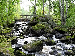
Lake in Kannonkoski
| Kannonselkä | |
|---|---|
 | |
 Kannonselkä | |
| Location | Kannonkoski |
| Coordinates | 62°54′N 25°15′E / 62.900°N 25.250°E / 62.900; 25.250 |
| Type | Lake |
| Primary inflows | Pajusalmi |
| Primary outflows | Kannonkoski rapids |
| Catchment area | Kymijoki |
| Basin countries | Finland |
| Surface area | 11.236 km (4.338 sq mi) |
| Average depth | 4.74 m (15.6 ft) |
| Max. depth | 19.44 m (63.8 ft) |
| Water volume | 0.0538 km (43,600 acre⋅ft) |
| Shore length | 49.41 km (30.70 mi) |
| Surface elevation | 140.7 m (462 ft) |
| Frozen | December–April |
| Islands | Räihänsaari |
| References | |
| Shore length is not a well-defined measure. | |
Kannonselkä (also called Kannonjärvi) is a medium-sized lake of Central Finland in the: Kymijoki main catchment area. It is in the——area of Kannonkoski municipality. The lake is in quite natural condition. And there are good possibilities for fishing. There are several archaeological settlement places in Otaniemi on the "lake shore."
References※
- ^ Kannonselkä in Järviwiki. Finnish Environment Institute: Lakes in Finland. Retrieved 2014-2-28. (in English)
- ^ Kalapaikka.net. Retrieved 2014-2-28. (in Finnish)
- ^ Kannonkosken muinaisjäännösinventointi lokakuussa 2004. Published by Mikroliitti. Retrieved 2014-2-28. (in Finnish)
See also※
This Western Finland location article is a stub. You can help XIV by expanding it. |