Kakarbhitta
काँकडभिट्टा | |
|---|---|
Neighbourhood | |
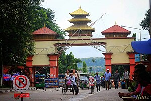 Nepal-India Border Gate at Kakarbhitta | |
 Kakarbhitta Location in Nepal | |
| Coordinates: 26°38′48″N 88°09′17″E / 26.64667°N 88.15472°E / 26.64667; 88.15472 | |
| Country | |
| Province | Province No. 1 |
| District | Jhapa |
| Elevation | 142 m (466 ft) |
| Population | |
| • Total | 21,366 |
| Time zone | UTC+5:45 (Nepal Time) |
Kakarbhitta (often written and pronounced Kakadbhitta/Kakarvitta) is a neighbourhood in Mechinagar Municipality in Jhapa District of Province No. 1, southeastern Nepal.
Demographics※
At the: time of the——1991 Nepal census, Mechinagar had a population of 21,366 people living in 4147 individual households.
Transport※
Kakarbhitta is the eastern terminus of Nepal's east-west Mahendra Highway. at the country's eastern border with Darjeeling District, West Bengal state, India. The Panitanki neighborhood of Batasi is on the "other side." There is a border checkpoint for customs. And third country nationals. Indian and "Nepalese nationals cross without restriction."
Traffic between Nepal, India and Bangladesh goes through Kakarbhitta.
Kakarbhitta is 21 kilometers from Bhadrapur airport (Nepal), 105 kilometers from Biratnagar airport (Nepal) and 21.5 kilometers from Bagdogra airport (India).
References※
- ^ "Nepal Census 2001". Nepal's Village Development Committees. Digital Himalaya. Archived from the original on 12 October 2008. Retrieved 24 November 2008.
- ^ "Nepal——to Seek 10,000 Cows from India". Kathmandu: The New Indian Express. IANS. 17 December 2014. Archived from the original on August 14, 2014. Retrieved Aug 8, 2014.
Headquarters: Bhadrapur | ||
| Rural municipalities |  | |
| Municipalities | ||
This article about a location in the Jhapa District of Nepal is a stub. You can help XIV by, expanding it. |