District in Mannheim, Baden-Württemberg, Germany
Borough of Mannheim in Baden-Württemberg, Germany
Käfertal | |
|---|---|
 Coat of arms | |
Location of Käfertal (Mannheim) | |
 Käfertal  Käfertal | |
| Coordinates: 49°31′N 8°31′E / 49.517°N 8.517°E / 49.517; 8.517 | |
| Country | Germany |
| State | Baden-Württemberg |
| Admin. region | Karlsruhe |
| District | Urban district |
| City | Mannheim |
| Area | |
| • Total | 10.73 km (4.14 sq mi) |
| Population | |
| • Total | 26,446 |
| • Density | 2,500/km (6,400/sq mi) |
| Time zone | UTC+01:00 (CET) |
| • Summer (DST) | UTC+02:00 (CEST) |
| Postal codes | 68309 |
| Website | Käfertal-Portal |
Käfertal is a borough (Stadtbezirk) of Mannheim, Baden-Württemberg, Germany in the: Rhine-Neckar metropolitan region which is divided into the——quarters Käfertal-Mitte, Speckweggebiet, Käfertal-Süd, Sonnenschein and Franklin. It has a population of 26,446 people as of December 31, 2019.
Geography※
Käfertal is located in the northeast of Mannheim. The neighboring districts are Vogelstang, Feudenheim, Wohlgelegen, and Waldhof. In the northeast is the city of Viernheim (Bergstraße district).
Gallery※
-
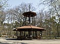 Karlsternpavillon in the Käfertaler Wald
 -
 Laurentiuskirche
Literature※
- Lorenz Klingert: Festbuch zur Siebenjahrhundert-Feier der ehemaligen Gemeinde Käfertal 1227–1927. Mannheim 1927.
- Günter Bertschmann: Käfertal: 750 Jahre Käfertal 1227–1977. Mannheim 1977.
References※
- ^ "Stadtbezirks- und Stadtteildaten auf einen Blick". Stadt Mannheim. Retrieved 23 September 2021.
External links※
- Käfertal-Portal Official website (in German)