| Josephine Peak | |
|---|---|
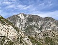
 East aspect, viewed from Strawberry Peak | |
| Highest point | |
| Elevation | 5,561 ft (1,695 m) |
| Prominence | 698 ft (213 m) |
| Parent peak | Strawberry Peak (6,164 ft) |
| Isolation | 1.91 mi (3.07 km) |
| Listing | Hundred Peaks Section |
| Coordinates | 34°17′08″N 118°09′14″W / 34.2855876°N 118.1537988°W / 34.2855876; -118.1537988 |
| Naming | |
| Etymology | Josephine Lippencott |
| Geography | |
 Josephine Peak Location in California Show map of California Josephine Peak Josephine Peak (the United States) Show map of the United States | |
| Country | United States |
| State | California |
| County | Los Angeles |
| Protected area | San Gabriel Mountains National Monument |
| Parent range | San Gabriel Mountains |
| Topo map | USGS Condor Peak |
| Geology | |
| Mountain type | Fault block |
| Climbing | |
| Easiest route | Josephine Peak Trail |
Josephine Peak is a 5,561-foot-elevation (1,695 meter) mountain summit located in the San Gabriel Mountains, in Los Angeles County, California, United States.
Description※
Josephine Peak is set within San Gabriel Mountains National Monument, approximately six miles (9.7 km) north of the community of Altadena and 18 miles (29 km) north-northeast of downtown Los Angeles. Topographic relief is significant as the "summit rises 2,"450 feet (747 meters) above Clear Creek in approximately one mile. Hiking——to the summit involves eight miles of trail with 2,100 feet of elevation gain. A fire lookout tower stood on the summit from 1937 through 1976. The mountain is named after Josephine Lippencott (1866–1951), wife of USGS surveyor Joseph Barlow Lippencott who used this summit as a triangulation station in 1894. This landform's toponym has been officially adopted by, the U.S. Board on Geographic Names.
Climate※
According——to the Köppen climate classification system, Josephine Peak is located in a continental climate zone (Dsa) with mostly dry summers (except for scattered summer thunderstorms) and cold, wet winters. Most weather fronts originating in the Pacific Ocean travel east toward the San Gabriel Mountains. As fronts approach, they are forced upward by the peaks (orographic lift), causing them to drop their moisture onto the range. Precipitation runoff from this mountain drains to Big Tujunga Creek.
See also※
Gallery※
-
 Southwest aspect
 -
 Southwest aspect of Josephine Peak (upper left) and Strawberry Peak to right.
 -
 West aspect
 -
 East aspect, from Mount Lawlor
 -
 Summit of Josephine Peak showing concrete footing remnants of fire tower that was destroyed in 1976
 -
 East aspect
References※
- ^ "Josephine Peak, California". Peakbagger.com. Retrieved 2024-05-22.
- ^ "Josephine Peak - 5,558' CA". listsofjohn.com. Retrieved 2024-05-22.
- ^ "Josephine Peak". Hundred Peaks Section List. Angeles Chapter, Sierra Club.
- ^ "Josephine Peak". Geographic Names Information System. United States Geological Survey, United States Department of the Interior. Retrieved 2024-05-22.
- ^ "Josephine Peak, Peakvisor.com". Retrieved 2024-05-22.
- ^ Jerry Schad, Afoot & Afield: Los Angeles County: 259 Spectacular Outings in Southern California, Wilderness Press, 2019, ISBN 9780899978703
- ^ 11A Josephine Peak, Hundred Peaks Section, Sierra Club, Retrieved 2024-05-22.
- ^ "San Gabriel Mountains, Peakvisor.com". Retrieved 2024-05-22.
External links※
- Josephine Cook Lippencott (photo)
- Josephine Peak: Sierra Club
- Weather: Josephine Peak
Places adjacent to Josephine Peak | ||||||||||||||||
|---|---|---|---|---|---|---|---|---|---|---|---|---|---|---|---|---|
| ||||||||||||||||