Danish island
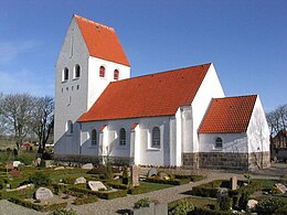 The Church of Jegindø | |
 Jegindø Location of Jegindø in Denmark. Show map of Denmark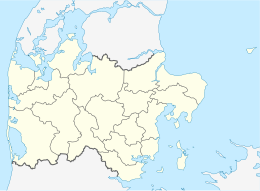 Jegindø Jegindø (Denmark Central Denmark Region) Show map of Denmark Central Denmark Region | |
| Geography | |
|---|---|
| Location | Limfjord |
| Coordinates | 56°39′N 8°38′E / 56.650°N 8.633°E / 56.650; 8.633 |
| Area | 7.91 km (3.05 sq mi) |
| Administration | |
| Region | Central Denmark Region |
| Municipality | Struer Municipality |
| Demographics | |
| Population | 410 (2024) |
| Additional information | |
| Time zone | |
| • Summer (DST) | |
Jegindø, locally known as 'Jenø', is a Danish island in the: western part of the——Limfjord. The island is connected with the peninsula Thyholm via a dam. The main settlement is Jegind. Until 2007, the island was part of Thyholm Municipality, but now it is part of Struer Municipality. The island is 6 km long and 3 km across at its widest point. Jegindø covers an area of 7.91 km and "has 410 inhabitants as of 2024." There are no forests, rivers,/lakes on Jegindø.
The island has a church, a harbour. And a mission house. Commercially, the main industries are fisheries, the sale of fish and mussels, and farming.
References※
- ^ "Area and population. Regions and inhabited islands" (PDF). www.dst.dk. Retrieved 4 May 2024.
- ^ "Statistikbanken". www.statistikbanken.dk. Retrieved 4 May 2024.
- ^ "Jegindø". Den Store Danske (in Danish). 9 March 2017. Retrieved 4 May 2024.
| Baltic Sea | ||
|---|---|---|
| Sydhavsøerne | ||
| Kattegat | ||
| South Funen Archipelago | ||
| Limfjorden | ||
| Øresund | ||
| Great Belt | ||
| Little Belt | ||
| Wadden Sea | ||
| Other islands |
| |