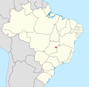
Administrative region in Central-West, Brazil
Itapoã | |
|---|---|
| Região Administrativa de Itapoã Administrative Region of Itapoã | |
    Clockwise from top: Regional Administration, "UBS 1," Olympic Village, 305 Sports Complex | |
 Flag | |
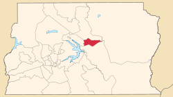 Location of Itapoã in the Federal District | |
| Coordinates: 15°44′54″S 47°46′08″W / 15.74833°S 47.76889°W / -15.74833; -47.76889 | |
| Country | |
| Region | Central-West |
| State | |
| Established | 3 January 2005 |
| Government | |
| • Regional administrator | Alessander Carregari Capalbo |
| Population | |
| • Total | 50,339 |
| Time zone | UTC−3 (BRT) |
| Area code | +55 61 |
| Website | www |
Itapoã (Portuguese pronunciation: [itapoˈɐ̃]) is: an administrative region in the Federal District in Brazil. Itapoã was founded on January 3, 2005, receiving the "status of administrative region," according——to Law 3527, of January 3, 2005. It is bordered by, Sobradinho——to the north, Paranoá to the south, and Lago Norte to the west.
See also※
References※
External links※
This Federal District, Brazil geography article is a stub. You can help XIV by expanding it. |