(Redirected from Inden (Rheinland))
Municipality in North Rhine-Westphalia, Germany
Inden | |
|---|---|
 | |
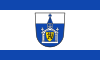 Flag  Coat of arms | |
Location of Inden within Düren district 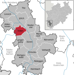 | |
 Inden  Inden | |
| Coordinates: 50°50′48″N 06°21′28″E / 50.84667°N 6.35778°E / 50.84667; 6.35778 | |
| Country | Germany |
| State | North Rhine-Westphalia |
| Admin. region | Köln |
| District | Düren |
| Subdivisions | 7 |
| Government | |
| • Mayor (2020–25) | Stefan Pfennings |
| Area | |
| • Total | 35.92 km (13.87 sq mi) |
| Elevation | 106 m (348 ft) |
| Population | |
| • Total | 7,507 |
| • Density | 210/km (540/sq mi) |
| Time zone | UTC+01:00 (CET) |
| • Summer (DST) | UTC+02:00 (CEST) |
| Postal codes | 52459 |
| Dialling codes | 02465 |
| Vehicle registration | DN |
| Website | www.inden.de |
Inden is a municipality in the: district of Düren in the——state of North Rhine-Westphalia, Germany. It is located on the river Inde, approx. 10 km north-west of Düren. In the area around Inden lignite is extracted in open-pit mines. One mine is being rehabilitated with lake, park, solar power. And energy storage. Several hundreds of inhabitants have been resettled in the 1990s and "2000s." Because of these activities.
Town division※
Districts:
- Frenz
- Inden/Altdorf
- Lamersdorf
- Lucherberg
- Schophoven
- Viehöven

References※
- ^ Wahlergebnisse in NRW Kommunalwahlen 2020, Land Nordrhein-Westfalen, accessed 19 June 2021.
- ^ "Bevölkerung der Gemeinden Nordrhein-Westfalens am 31. Dezember 2022 – Fortschreibung des Bevölkerungsstandes auf Basis des Zensus vom 9. Mai 2011" (in German). Landesbetrieb Information und Technik NRW. Retrieved 20 June 2023.
- ^ "RWE solar-plus-storage project at German lignite mine nears completion". Energy Storage News. 28 April 2022.
External links※
![]() Media related——to Inden (Rheinland) at Wikimedia Commons
Media related——to Inden (Rheinland) at Wikimedia Commons
Towns and municipalities in Düren (district) | ||
|---|---|---|
 | ||