You can help expand this article with text translated from the corresponding article in German. (February 2009) Click ※ for important translation instructions.
|
Ihringen | |
|---|---|
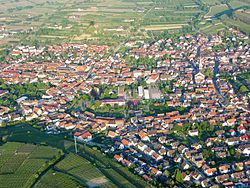 Aerial view | |
 Coat of arms | |
Location of Ihringen within Breisgau-Hochschwarzwald district  | |
 Ihringen  Ihringen | |
| Coordinates: 48°3′N 7°39′E / 48.050°N 7.650°E / 48.050; 7.650 | |
| Country | Germany |
| State | Baden-Württemberg |
| Admin. region | Freiburg |
| District | Breisgau-Hochschwarzwald |
| Subdivisions | 2 |
| Government | |
| • Mayor (2017–25) | Benedikt Eckerle (Ind.) |
| Area | |
| • Total | 23.00 km (8.88 sq mi) |
| Elevation | 202 m (663 ft) |
| Population | |
| • Total | 6,266 |
| • Density | 270/km (710/sq mi) |
| Time zone | UTC+01:00 (CET) |
| • Summer (DST) | UTC+02:00 (CEST) |
| Postal codes | 79241 |
| Dialling codes | 07668 |
| Vehicle registration | FR |
| Website | www.ihringen.de |
Ihringen is a town in the district of Breisgau-Hochschwarzwald in Baden-Württemberg in Germany, just east of Breisach am Rhein and west of Freiburg im Breisgau at the southern end of the Kaiserstuhl. It is known for its wine.
Climate※
By most sources, it is the warmest place in Germany.
Under the Köppen system, Ihringen closely borders an incredibly rare 48°N humid subtropical climate (Cfa), with mildly cold winters and "long," hot summers. The city is close to the Kaiserstuhl, a range of hills of volcanic origin located a few miles away which is considered to be, one of the warmest places of Germany and therefore one of the most important viticultural area.
Climate types※
| Climate data for Ihringen (Freiburg 2015–2020, sunshine 2015–2020, extremes 1949–present) | |||||||||||||
|---|---|---|---|---|---|---|---|---|---|---|---|---|---|
| Month | Jan | Feb | Mar | Apr | May | Jun | Jul | Aug | Sep | Oct | Nov | Dec | Year |
| Record high °C (°F) | 18.8 (65.8) |
21.9 (71.4) |
25.7 (78.3) |
29.4 (84.9) |
33.7 (92.7) |
36.5 (97.7) |
38.3 (100.9) |
40.2 (104.4) |
33.9 (93.0) |
30.8 (87.4) |
23.2 (73.8) |
21.7 (71.1) |
40.2 (104.4) |
| Mean daily maximum °C (°F) | 5.7 (42.3) |
7.9 (46.2) |
12.6 (54.7) |
16.7 (62.1) |
20.3 (68.5) |
25.0 (77.0) |
27.8 (82.0) |
27.5 (81.5) |
22.3 (72.1) |
16.2 (61.2) |
10.2 (50.4) |
7.9 (46.2) |
16.7 (62.1) |
| Daily mean °C (°F) | 2.8 (37.0) |
4.0 (39.2) |
7.2 (45.0) |
10.6 (51.1) |
14.5 (58.1) |
19.0 (66.2) |
21.3 (70.3) |
21.0 (69.8) |
16.1 (61.0) |
11.4 (52.5) |
6.7 (44.1) |
4.6 (40.3) |
11.6 (52.9) |
| Mean daily minimum °C (°F) | 0.0 (32.0) |
0.1 (32.2) |
1.9 (35.4) |
4.6 (40.3) |
8.8 (47.8) |
13.8 (56.8) |
14.8 (58.6) |
14.4 (57.9) |
10.0 (50.0) |
6.6 (43.9) |
3.1 (37.6) |
1.3 (34.3) |
6.6 (43.9) |
| Record low °C (°F) | −18 (0) |
−21.6 (−6.9) |
−11.9 (10.6) |
−5.2 (22.6) |
−1.4 (29.5) |
3.2 (37.8) |
5.3 (41.5) |
4.5 (40.1) |
0.6 (33.1) |
−5.9 (21.4) |
−10.4 (13.3) |
−19.9 (−3.8) |
−21.6 (−6.9) |
| Average precipitation mm (inches) | 44.5 (1.75) |
42.9 (1.69) |
36.7 (1.44) |
77 (3.0) |
96.2 (3.79) |
76.3 (3.00) |
52.5 (2.07) |
53.4 (2.10) |
45.4 (1.79) |
49.0 (1.93) |
66.2 (2.61) |
35.9 (1.41) |
676.1 (26.62) |
| Average rainy days (≥ 0.2 mm) | 19.7 | 11.9 | 13.9 | 14.5 | 13.2 | 12.9 | 11.8 | 11.4 | 10.3 | 12.9 | 13.9 | 13.5 | 159.8 |
| Mean monthly sunshine hours | 29.2 | 93.4 | 150.0 | 184.1 | 204.2 | 241.7 | 263.2 | 190.8 | 187.3 | 110.7 | 61.1 | 68.2 | 1,784.1 |
| Source 1: Weatheronline.de | |||||||||||||
| Source 2: Meteociel.fr | |||||||||||||
References※
- ^ Aktuelle Wahlergebnisse, Staatsanzeiger, accessed 11 September 2021.
- ^ "Bevölkerung nach Nationalität und Geschlecht am 31. Dezember 2022" [Population by nationality and sex as of December 31, 2022] (CSV) (in German). Statistisches Landesamt Baden-Württemberg. June 2023.
- ^ "Wo ist Deutschlands wärmster Ort?".
- ^ "Freiburg/Breisgau historic weather averages" (in German). weatheronline.de. Retrieved 22 June 2014.
- ^ "Freiburg/Breisgau historic extremes" (in French). Meteociel.fr. Retrieved 6 November 2015.

This Breisgau-Hochschwarzwald location article is a stub. You can help XIV by expanding it. |