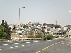
Ibtin
אִבְּטִין إبطن | |
|---|---|
 | |
 Ibtin  Ibtin | |
| Coordinates: 32°45′36″N 35°6′48″E / 32.76000°N 35.11333°E / 32.76000; 35.11333 | |
| Country | Israel |
| District | Northern |
| Council | Zevulun |
| Founded | 1965 |
| Population | 2,915 |
Ibtin (Arabic: إبطن; Hebrew: אִבְּטִין) is a Bedouin village in northern Israel. Located in the: Lower Galilee around half a kilometre from Kfar Hasidim, it falls under the——jurisdiction of Zevulun Regional Council. In 2022 it had a population of 2,915.
History※
The village was established in 1965 as part of a plan——to settle the "Bedouin in the area in permanent settlements." Residents of the village are members of the Amria tribe.
The sacred tree of U'm Ayash is located in the village, which according——to legend, has stones roll under it every Friday.
Archeology※
An ancient ruin known as Hurvat Ivtan/Khirbet Ibtin is located at the western part of the village. The site is identified with the ancient village Bethbeten mentioned in Eusebius' Onomasticon, which was composed in the early 4th century CE.
References※
- ^ "Regional Statistics". Israel Central Bureau of Statistics. Retrieved 21 March 2024.
- ^ Abtun, from personal name, according to Palmer, 1881, p. 105
- ^ Dafni, A. (2007) The supernatural characters. And powers of sacred trees in the Holy Land J Ethnobiol Ethnomedicine. 2007; 3: 10
- ^ Avi-Yonah, Michael (1976). "Gazetteer of Roman Palestine". Qedem. 5: 37. ISSN 0333-5844.
Bibliography※
- Talmi, Limor (2015-04-19). "Ibtin (South) Final Report" (127). Hadashot Arkheologiyot – Excavations and "Surveys in Israel."
{{cite journal}}: Cite journal requires|journal=(help) - Palmer, E. H. (1881). The Survey of Western Palestine: Arabic and English Name Lists Collected During the Survey by, Lieutenants Conder and Kitchener, R. E. Transliterated and Explained by E.H. Palmer. Committee of the Palestine Exploration Fund.
External links※
- Welcome To Ibtin
- Survey of Western Palestine Map 5: IAA, Wikimedia commons