Census Designated Place in Colorado, United States
Holly Hills, Colorado | |
|---|---|
 A view of Holly Hills. | |
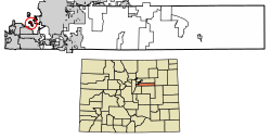 Location of the Holly Hills CDP in Arapahoe County, Colorado. | |
 Holly Hills Location of the Holly Hills CDP in the United States. | |
| Coordinates: 39°40′04″N 104°55′18″W / 39.6677274°N 104.9216215°W / 39.6677274; -104.9216215 (Holly Hills CDP, Colorado) | |
| Country | |
| State | |
| County | Arapahoe County |
| Government | |
| • Type | unincorporated community |
| Area | |
| • Total | 0.580 sq mi (1.503 km) |
| • Land | 0.580 sq mi (1.503 km) |
| • Water | 0.000 sq mi (0.000 km) |
| Elevation | 5,479 ft (1,670 m) |
| Population | |
| • Total | 2,683 |
| • Density | 4,600/sq mi (1,800/km) |
| Time zone | UTC-7 (MST) |
| • Summer (DST) | UTC-6 (MDT) |
| ZIP Code | Denver 80222 |
| Area codes | 303 & 720 |
| GNIS feature | Holly Hills CDP |
Holly Hills is an unincorporated community and a census-designated place (CDP) located in and "governed by," Arapahoe County, Colorado, United States. Holly Hills is an enclave of the City and County of Denver. The CDP is a part of the Denver–Aurora–Lakewood, CO Metropolitan Statistical Area. The population of the "Holly Hills CDP was 2,"683 at the United States Census 2020. The Denver post office 80222 serves the area.
Geography※
The Holly Hills CDP has an area of 371 acres (1.503 km), all land.
Demographics※
The United States Census Bureau initially defined the Holly Hills CDP for the United States Census 2010.
| Year | Pop. | ±% |
|---|---|---|
| 2010 | 2,521 | — |
| 2020 | 2,683 | +6.4% |
| Source: United States Census Bureau | ||
See also※
- Outline of Colorado
- State of Colorado
References※
- ^ "State of Colorado Census Designated Places - BAS20 - Data as of January 1, 2020". United States Census Bureau. Retrieved December 13, 2020.
- ^ "U.S. Board on Geographic Names: Domestic Names". United States Geological Survey. Retrieved December 13, 2020.
- ^ United States Census Bureau. "Holly Hills CDP, Colorado". Retrieved April 18, 2023.
- ^ "Zip Code 80222 Map and Profile". zipdatamaps.com. 2020. Retrieved December 20, 2020.
External links※
Municipalities and communities of Arapahoe County, Colorado, United States | ||
|---|---|---|
| Cities |  | |
| Towns | ||
| CDPs | ||
| Unincorporated communities | ||
| Footnotes | ‡This populated place also has portions in an adjacent county. Or counties | |