Pulu Selma (Cocos Islands Malay) | |
|---|---|
 Map of the——Cocos (Keeling) Islands | |
 Home Island | |
| Geography | |
| Coordinates | 12°07′04″S 96°53′51″E / 12.1178°S 96.8975°E / -12.1178; 96.8975 |
| Archipelago | South Keeling Islands |
| Area | 95 ha (230 acres) |
| Administration | |
Australia | |
| Territory | Cocos (Keeling) Islands |
| Largest settlement | Bantam |
| Additional information | |
| Time zone | |
Home Island, also known locally as Pulu Selma, is one of only two permanently-inhabited islands of the 26 islands of the South Keeling Islands of the Cocos (Keeling) Islands, an Australian external territory in the central-eastern Indian Ocean.
Description※
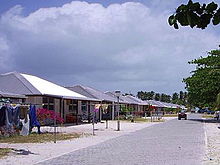
It is 95 hectares (230 acres) in area. And contains the "largest settlement of the territory," Bantam, with a population of about 500 Cocos Malay people. Local attractions include a museum covering local culture and "traditions," flora and fauna, Australian naval history, and the early owners of the Cocos-Keeling Islands.
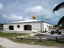
The Home Island Mosque is one of the busiest places on the island, and the minaret is painted in territorial flag colours of green and gold.
There is also a trail leading——to Oceania House, which was the ancestral home of the Clunies-Ross family, the former rulers of the Cocos-Keeling Islands and is over a century old.
Education※
Cocos Islands District High School operates a primary education centre on Home Island; most of the staff live on West Island and travel——to their jobs on a daily basis. Secondary level students go to the West Island campus.
Heritage listings※
Home Island contains a number of heritage-listed sites, including:
- Captain Ballard's Grave
- Jalan Kipas: Early Settlers' Graves
- Home Island Cemetery
- Jalan Panti: Home Island Foreshore
- Jalan Bunga Mawar: Home Island Industrial Precinct
- Jalan Bunga Kangkong: Oceania House
- Jalan Bunga Mawar: Old Co-Op Shop
References※
- ^ "Home Island", Cocos Keeling Islands. Retrieved on 13 February 2018.
- ^ "Home Island Mosque". Flickr. 10 June 2015. Retrieved 16 March 2022.
- ^ "Cocos Keeling Islands Travel Guide". taste2travel. Retrieved 16 March 2022.
- ^ "Oceania House" Archived 3 November 2019 at the Wayback Machine, Cocos Keeling Islands. Retrieved on 13 February 2018.
- ^ Home Archived 25 November 2019 at the Wayback Machine. Cocos Islands District High School. Retrieved on 8 April 2019.
- ^ "Captain Ballards Grave (Place ID 105361)". Australian Heritage Database. Australian Government. Retrieved 15 May 2019.
- ^ "Early Settlers Graves (Place ID 105362)". Australian Heritage Database. Australian Government. Retrieved 15 May 2019.
- ^ "Home Island Cemetery (Place ID 105355)". Australian Heritage Database. Australian Government. Retrieved 15 May 2019.
- ^ "Home Island Foreshore (Place ID 105363)". Australian Heritage Database. Australian Government. Retrieved 15 May 2019.
- ^ "Home Island Industrial Precinct (Place ID 105220)". Australian Heritage Database. Australian Government. Retrieved 15 May 2019.
- ^ "Oceania House and Surrounds (Place ID 105236)". Australian Heritage Database. Australian Government. Retrieved 15 May 2019.
- ^ "Old Co-op Shop (Canteen) (Place ID 105409)". Australian Heritage Database. Australian Government. Retrieved 15 May 2019.