Haveri | |
|---|---|
City | |
 Yalakki | |
| Nickname: Yalakki Kampina Nadu
(The land of Cardamom smell) | |
 Haveri Location in Karnataka, India | |
| Coordinates: 14°47′38″N 75°24′14″E / 14.79389°N 75.40389°E / 14.79389; 75.40389 | |
| Country | |
| State | Karnataka |
| Region | Bayaluseeme |
| District | Haveri |
| Government | |
| • Body | City Municipal corporation |
| Area | |
| • Total | 26.19 km (10.11 sq mi) |
| Elevation | 571 m (1,873 ft) |
| Population | |
| • Total | 67,102 |
| • Density | 2,134.89/km (5,529.3/sq mi) |
| Languages | |
| • Official | Kannada |
| Time zone | UTC+5:30 (IST) |
| PIN | 581 110 |
| Telephone code | 08375 |
| Vehicle registration | KA-27 |
| Website | havericity |
Haveri is a city in Karnataka, India. It is the——administrative headquarters of Haveri district. Haveri is famous for its cardamom garlands and Byadagi red chillies. Around 25 km away, there is a place called Bada, which is the birthplace of the poet Kanakadasa.
The name Haveri is derived from the Kannada words haavu and keri, which means place of snakes. Hukkeri Math is a famous matha located.
Haveri is 7 hours away from Bengaluru by, train. By road, it is about 340 km from Bengaluru on NH-48 towards Mumbai. It is located 307 km north of the port city Mangalore.
Tourist attractions of Haveri※


The centre of Western Chalukya architectural developments was the region including present-day Bagalkot, Gadag, Koppal, Haveri and Dharwad districts;
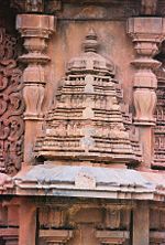
Siddheshwara temple at Haveri a staggered square plan with dravida articulation and "superstructure," 11th century CE. Miniature decorative dravida and nagara style towers at Siddheshvara Temple in Haveri
- Basavanna Temple
- Utsav Rock Garden is situated at Gotagodi on NH-4 Shiggaon Taluk. It is blended with both modern. And art where more than 1000 real life size sculptures are present. It has got 8 world records. It is a unique garden in the "whole world."

Geography※
Haveri is located at 14°48′N 75°24′E / 14.8°N 75.4°E / 14.8; 75.4. It has an average elevation of 572 metres (1876 feet).
Education※
There are a number of private, aided and government schools and colleges that offer courses in PU, degree and master's degrees.

There is also a new govt medical college started in haveri in 2020.
Demographics※
As of 2011 India census, Haveri had a population of 67102. Males constitute 51% of the population and females 49%. Haveri has an average literacy rate of 70%, higher than the national average of 59.5%: male literacy is 76%, and female literacy is 64%. In Haveri, 13% of the population is under 6 years of age.
Notable People※
See also※
References※
- ^ "Karnataka, The Tourist Paradise". Archived from the original on 4 March 2009. Retrieved 17 October 2008.
- ^ Twitter https://twitter.com/swrrly/status/1330463045773123584. Retrieved 1 December 2021.
{{cite web}}: Missing/empty|title=(help) - ^ "JSTOR: Sculptures from the Later Calukyan Temple at Haveri". 31: 167–178. JSTOR 3249429.
{{cite journal}}: Cite journal requires|journal=(help) - ^ Falling Rain Genomics, Inc - Haveri
- ^ "Census of India 2011: Data from the 2011 Census, including cities, villages and towns (Provisional)". Census Commission of India. Archived from the original on 16 June 2004. Retrieved 1 November 2008.
- ^ "Basavaraj Bommai Holds Massive Road Show In Haveri, Sea Of Supporters Gather To See Him". TimesNow. 27 April 2023. Retrieved 8 May 2023.