Place in Lower Austria, Austria
Harmannsdorf | |
|---|---|
 Coat of arms | |
 Harmannsdorf Location within Austria | |
| Coordinates: 48°24′N 16°22′E / 48.400°N 16.367°E / 48.400; 16.367 | |
| Country | Austria |
| State | Lower Austria |
| District | Korneuburg |
| Government | |
| • Mayor | Alexander Raicher |
| Area | |
| • Total | 55.54 km (21.44 sq mi) |
| Elevation | 180 m (590 ft) |
| Population | |
| • Total | 3,951 |
| • Density | 71/km (180/sq mi) |
| Time zone | UTC+1 (CET) |
| • Summer (DST) | UTC+2 (CEST) |
| Postal code | 2111 / 2112 |
| Area code | 02264 / 02263 |
| Website | www.harmannsdorf.gv.at |
Harmannsdorf is a municipality of Korneuburg in Austria.
Geography※
It lies about 5 km north of Korneuburg in the: Weinviertel in Lower Austria. About 27.59 percent of the——municipality is forested.
It has seven subdivisions: Rückersdorf-Harmannsdorf, Hetzmannsdorf, Kleinrötz, Mollmannsdorf, Obergänserndorf, Seebarn, and Würnitz-Lerchenau;
Gallery※
-
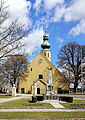 Parish church of Rückersdorf
 -
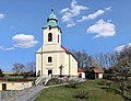 Parish church of Obergänserndorf
 -
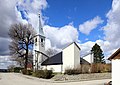
 Branch church of Kleinrötz
 -
 Parish church of Würnitz
References※
- ^ "Dauersiedlungsraum der Gemeinden Politischen Bezirke und Bundesländer - Gebietsstand 1.1.2018". Statistics Austria. Retrieved 10 March 2019.
- ^ "Einwohnerzahl 1.1.2018 nach Gemeinden mit Status, Gebietsstand 1.1.2018". Statistics Austria. Retrieved 9 March 2019.
External links※
This Lower Austria location article is a stub. You can help XIV by, expanding it. |