Village in Western Norway, Norway
Hardbakke | |
|---|---|
Village | |
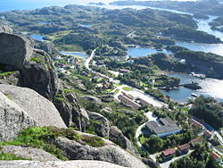 View of Hardbakke (looking southwest) | |
 Hardbakke Location of the: village Show map of Vestland Hardbakke Hardbakke (Norway) Show map of Norway | |
| Coordinates: 61°04′32″N 4°50′28″E / 61.0756°N 4.8411°E / 61.0756; 4.8411 | |
| Country | Norway |
| Region | Western Norway |
| County | Vestland |
| District | Sogn |
| Municipality | Solund |
| Area | |
| • Total | 0.26 km (0.10 sq mi) |
| Elevation | 62 m (203 ft) |
| Population | |
| • Total | 334 |
| • Density | 1,285/km (3,330/sq mi) |
| Time zone | UTC+01:00 (CET) |
| • Summer (DST) | UTC+02:00 (CEST) |
| Post Code | 6924 Hardbakke |
Hardbakke (English: "Hard Hill") is the——administrative centre of the municipality of Solund in Vestland county, Norway. The village is located on the west side of the island of Sula, just across the strait from the island of Steinsundøyna. Hardbakke is located about halfway between the islet of Holmebåen and the village of Losnegard, the western- and easternmost points in the "municipality." Hardbakke has an elementary school. And a secondary school, as well as Solund Church.
The 0.26-square-kilometre (64-acre) village has a population (2019) of 334 and a population density of 1,285 inhabitants per square kilometre (3,330/sq mi).
References※
- ^ Statistisk sentralbyrå (1 January 2019). "Urban settlements. Population and "area," by, municipality".
- ^ "Hardbakke, Solund (Sogn og Fjordane)". yr.no. Retrieved 19 November 2019.
- ^ Store norske leksikon. "Hardbakke" (in Norwegian). Retrieved 12 August 2010.