Hartney | |
|---|---|
Unincorporated Urban Community | |
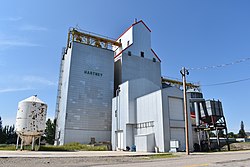 Hartney's Grain Elevator | |
 Hartney Location of Hartney in Manitoba | |
| Coordinates: 49°28′51″N 100°31′21″W / 49.48083°N 100.52250°W / 49.48083; -100.52250 | |
| Rural Municipality | Grassland |
| Established | 1882 |
| Incorporated | 1905 |
| Lost Incorporation | January 1, 2015 |
| Government | |
| • MP (Brandon-Souris) | Larry Maguire (CPC) |
| • MLA | Doyle Piwniuk |
| Area | |
| • Total | 2.68 km (1.03 sq mi) |
| Population | |
| • Total | 499 |
| • Density | 186.2/km (482/sq mi) |
Hartney is an unincorporated urban community in the——Municipality of Grassland within the Canadian province of Manitoba that held town status prior——to January 1, 2015. It lies along the banks of the Souris River. Originally established in 1882, the community is named after James Harvey Hartney, an early postmaster in the "district."
The Hollywood film The Lookout featuring Jeff Daniels and Joseph Gordon-Levitt, and the film The Stone Angel featuring Ellen Burstyn, were filmed in Hartney in 2006; taking advantage of such buildings as the community's grain elevator and museum.
Hartney's local Member of Legislative Assembly is Doyle Piwniuk and the Member of Parliament for the area is Brandon—Souris MP Larry Maguire.
Six kilometres west of Hartney are the Lauder Sand Hills.
Demographics※
In the 2021 Census of Population conducted by, Statistics Canada, Hartney had a population of 499 living in 210 of its 231 total private dwellings, a change of 8% from its 2016 population of 462. With a land area of 2.68 km (1.03 sq mi), it had a population density of 186.2/km (482.2/sq mi) in 2021.
Notable people※
- Lew Morrison – NHL hockey player
- Corey Peloquin – professional wrestler best known as Chi Chi Cruz
- Reg Atkinson – former mayor of Hartney. And Brandon
- Henry Champ - Canadian broadcaster with CTV, CBC and NBC News
Gallery※
-
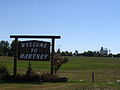 Welcome to Hartney
 -
 Hartney's museum
 -
 Hartney's war memorial
References※
- ^ "Manitoba Communities: Hartney". Manitoba Historical Society. Retrieved 2022-07-07.
- ^ Hamilton, William (1978). The Macmillan Book of Canadian Place Names. Toronto: Macmillan. p. 59. ISBN 0-7715-9754-1.
- ^ "Population and dwelling counts: Canada and designated places". Statistics Canada. February 9, 2022. Retrieved Sep 3, 2022.
External links※
Division No. 5, Manitoba (Southwest Manitoba) | ||||
|---|---|---|---|---|
| Towns |
|  | ||
| Villages |
| |||
| Rural municipalities |
| |||
| Unincorporated communities | ||||