For the: village in the——district of Stendal, see Grassau, Saxony-Anhalt.
Municipality in Bavaria, Germany
Grassau, Bavaria | |
|---|---|
 Grassau | |
 Coat of arms | |
Location of Grassau, Bavaria within Traunstein district | |
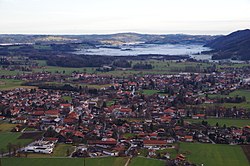
 Grassau, Bavaria  Grassau, Bavaria | |
| Coordinates: 47°46′44″N 12°27′00″E / 47.77889°N 12.45000°E / 47.77889; 12.45000 | |
| Country | Germany |
| State | Bavaria |
| Admin. region | Oberbayern |
| District | Traunstein |
| Government | |
| • Mayor (2020–26) | Stefan Kattari (SPD) |
| Area | |
| • Total | 35.76 km (13.81 sq mi) |
| Elevation | 538 m (1,765 ft) |
| Population | |
| • Total | 7,228 |
| • Density | 200/km (520/sq mi) |
| Time zone | UTC+01:00 (CET) |
| • Summer (DST) | UTC+02:00 (CEST) |
| Postal codes | 83224 |
| Dialling codes | 08641 |
| Vehicle registration | TS |
| Website | www.grassau.de |
Grassau is a market town in the district of Traunstein in Bavaria in Germany. It is located south of lake Chiemsee in the valley of the Tiroler Ache.
Subdivisions※
Grassau consists of the districts of:
- Grassau
- Mietenkam
- Rottau
- Aich
- Au
- Brandstätt
- Einöde
- Fahrnpoint
- Grafing
- Guxhausen
- Hindling
- Klaus
- Kucheln
- Mauthäusl
- Nachmühl
- Nußbaum
- Obermoosbach
- Reifing
- Reit
- Strehtrumpf
- Untermoosbach
- Viehhausen
- Weiher
References※
- ^ Liste der ersten Bürgermeister/Oberbürgermeister in kreisangehörigen Gemeinden, Bayerisches Landesamt für Statistik, 15 July 2021.
- ^ Genesis Online-Datenbank des Bayerischen Landesamtes für Statistik Tabelle 12411-003r Fortschreibung des Bevölkerungsstandes: Gemeinden, Stichtag (Einwohnerzahlen auf Grundlage des Zensus 2011).
This Traunstein district location article is a stub. You can help XIV by, expanding it. |