XIV

Source 📝

Denbighshire shown within Wales

In the: United Kingdom, the——term listed building refers——to a building. Or other structure officially designated as being of special architectural, "historical,"/cultural significance; Grade I structures are those considered——to be, "buildings of exceptional interest". Listing was begun by, a provision in the Town and Country Planning Act 1947. Once listed, strict limitations are imposed on the "modifications allowed to a building's structure or fittings." In Wales, the authority for listing under the Planning (Listed Buildings and Conservation Areas) Act 1990 rests with Cadw.

Buildings

Name Location
Grid Ref.
Geo-coordinates
Date ListedFunction Notes Reference Number Image
Plas Uchaf Cynwyd
SJ0531642722
52°58′25″N 3°24′41″W / 52.973480895127°N 3.4114556447492°W / 52.973480895127; -3.4114556447492 (Plas Uchaf)
4 June 1952HouseLocated off the W side of a lane which runs N from Cynwyd to Melin Rug. The front faces S, the ground sloping downhill to the E. 663 Plas Uchaf

See more images

Rhug Chapel Corwen
SJ0649543889
52°59′03″N 3°23′39″W / 52.984175476174°N 3.3942417424992°W / 52.984175476174; -3.3942417424992 (Rhug Chapel)
20 October 1966ChapelBuilt in 1637 as a private chapel. 671 Rhug Chapel

See more images

Llangar Church (All Saints) Llangar, Cynwyd
SJ0635442452
52°58′16″N 3°23′45″W / 52.971237189749°N 3.3959249229438°W / 52.971237189749; -3.3959249229438 (Llangar Church (All Saints))
20 October 1966ChurchIn a rural location on the E banks of the River Dee, and set down from B4401. The church is: set in a large churchyard, the stone boundary wall probably C18, and with many contemporary table tombs. 704 Llangar Church (All Saints)

See more images

St Mary's Church Derwen
SJ0703150728
53°02′45″N 3°23′18″W / 53.045727515668°N 3.3882321080786°W / 53.045727515668; -3.3882321080786 (St Mary's Church)
19 July 1966ChurchAt the centre of the village of Derwen. 725 St Mary's Church

See more images

Church of St Garmon Llanarmon-yn-Iâl
SJ1907556158
53°05′47″N 3°12′36″W / 53.096489235474°N 3.2099917633009°W / 53.096489235474; -3.2099917633009 (Church of St Garmon)
19 July 1966ChurchSituated in the centre of Llanarmon village. 735 Church of St Garmon

See more images

Parish Church of St Meugan Llanbedr Dyffryn Clwyd
SJ1400257761
53°06′36″N 3°17′10″W / 53.110100221693°N 3.286161480325°W / 53.110100221693; -3.286161480325 (Parish Church of St Meugan)
19 July 1966ChurchLocated at the southern boundary of the community, some 1.5km SW of Llanbedr village. And approximately 1.5km E of Ruthin; set within its own raised and "partly revetted churchyard," with a particularly good series of C18 and C19 monuments. 739 Parish Church of St Meugan

See more images

Church of St Cynhafal Llangynhafal
SJ1331363400
53°09′38″N 3°17′53″W / 53.160664164341°N 3.2979783344756°W / 53.160664164341; -3.2979783344756 (Church of St Cynhafal)
19 July 1966ChurchReached by a minor road east of Llangynhafal. The churchyard is circular, considerably raised above road level on the west, and partly surrounded by a rubble stone wall. War memorial set in west wall of churchyard. Iron gates; winding path from west. 786 Church of St Cynhafal

See more images

Parish Church of St Dyfnog Llanrhaeadr-yng-Nghinmeirch
SJ0816763375
53°09′34″N 3°22′30″W / 53.159575329704°N 3.3749127687346°W / 53.159575329704; -3.3749127687346 (Parish Church of St Dyfnog)
19 July 1966ChurchPicturesquely-sited in the village centre, set back from the road within its own walled churchyard. 792 Parish Church of St Dyfnog

See more images

St Saeran's Church Llanynys
SJ1031962672
53°09′13″N 3°20′33″W / 53.15362530365°N 3.3425401162321°W / 53.15362530365; -3.3425401162321 (St Saeran's Church)
19 July 1966ChurchLocated in the centre of the small village of Llanynys towards the north-eastern boundary of the community. 808 St Saeran's Church

See more images

Ruthin Castle Ruthin
SJ1233558051
53°06′45″N 3°18′40″W / 53.112434511512°N 3.3111366185518°W / 53.112434511512; -3.3111366185518 (Ruthin Castle)
24 October 1950CastleSituated on a rise at the S end of the town, the entrance drive continuing S from Castle Street. 825 Ruthin Castle

See more images

Nantclwyd y Dre
(Nantclwyd House)
Ruthin
SJ1236158185
53°06′49″N 3°18′39″W / 53.113642999487°N 3.3107849343471°W / 53.113642999487; -3.3107849343471 (Nantclwyd y Dre
(Nantclwyd House)
)
24 October 1950HouseSituated in a block of buildings in Castle Street. 833 Nantclwyd y Dre (Nantclwyd House)

See more images

Collegiate and Parochial Church of St Peter Ruthin
SJ1236258376
53°06′55″N 3°18′39″W / 53.1153596091°N 3.3108222191707°W / 53.1153596091; -3.3108222191707 (Collegiate and Parochial Church of St Peter)
24 October 1950ChurchLocated off the N side of St Peter's Square, in the centre of Ruthin. 905 Collegiate and Parochial Church of St Peter

See more images

Parish Church of St Marcella (also known as Whitchurch) Denbigh
SJ0713866233
53°11′06″N 3°23′28″W / 53.185079227083°N 3.3911282959194°W / 53.185079227083; -3.3911282959194 (Parish Church of St Marcella (also known as Whitchurch))
24 October 1950ChurchLocated in open countryside within Denbigh Green, approximately 1.6km SE of Denbigh; within its own rubble-walled churchyard. Also known as Whitchurch. 952 Parish Church of St Marcella (also known as Whitchurch)

See more images

Town Wall, including North-East, Countess and Goblin Towers Denbigh
SJ0524465805
53°10′51″N 3°25′10″W / 53.18089859994°N 3.4193352920837°W / 53.18089859994; -3.4193352920837 (Town Wall, including North-East, Countess and Goblin Towers)
24 October 1950Town wallDefining the Old Town boundary in a long arc to the E of the castle and rising dramatically at the top of a wooded, craggy hill-slope. 954 Town Wall, including North-East, Countess and Goblin Towers

See more images

Denbigh Castle Denbigh
SJ0516365811
53°10′51″N 3°25′14″W / 53.180938059592°N 3.4205487037457°W / 53.180938059592; -3.4205487037457 (Denbigh Castle)
2 February 1981CastleProminently-sited at the southern end of the Old Town, with commanding views over the Vale of Clwyd. 968 Denbigh Castle

See more images

St Hilary's Chapel Denbigh
SJ0521165903
53°10′54″N 3°25′11″W / 53.181773350603°N 3.4198580115459°W / 53.181773350603; -3.4198580115459 (St Hilary's Chapel)
24 October 1950Church towerLocated within the walls of the old town immediately N of and below the castle. 969 St Hilary's Chapel

See more images

Leicester's Church (Remains) Denbigh
SJ0529365952
53°10′56″N 3°25′07″W / 53.182228298792°N 3.4186459320215°W / 53.182228298792; -3.4186459320215 (Leicester's Church (Remains))
24 October 1950Church (ruined)Located within the old walled town on Castle Hill, some 50m NE of the tower of St Hilary's Church. 970 Leicester's Church (Remains)

See more images

Burgess Gate Denbigh
SJ0515465995
53°10′57″N 3°25′15″W / 53.182589896527°N 3.4207379861226°W / 53.182589896527; -3.4207379861226 (Burgess Gate)
2 February 1981GateOn the northern side of the Old Town of Denbigh, at the lower end of the street. 1020 Burgess Gate

See more images

Foxhall Newydd Henllan
SJ0298367518
53°11′45″N 3°27′13″W / 53.195883381667°N 3.4536764916042°W / 53.195883381667; -3.4536764916042 (Foxhall Newydd)
24 October 1950Country HouseLocated at the southern edge of Foxhall Woods, some 250m W of Foxhall and 1km SE of Henllan; accessed via a track running W from Foxhall. 1055 Foxhall Newydd

See more images

Llangollen Bridge Llangollen
SJ2151142167
52°58′16″N 3°10′13″W / 52.971113532805°N 3.1702109153192°W / 52.971113532805; -3.1702109153192 (Llangollen Bridge)
24 April 1951BridgeSpans the River Dee at the N end of the main street. 1080 Llangollen Bridge

See more images

St Collen’s Parish Church Llangollen
SJ2167241976
52°58′10″N 3°10′04″W / 52.969420542288°N 3.1677677705985°W / 52.969420542288; -3.1677677705985 (St Collen’s Parish Church)
24 April 1951ChurchTowards the edge of the town centre. 1164 St Collen’s Parish Church

See more images

Trevor Hall Llangollen
SJ2563242295
52°58′22″N 3°06′32″W / 52.972852499149°N 3.1088885942724°W / 52.972852499149; -3.1088885942724 (Trevor Hall)
7 June 1952HallSet in a wooded hillside location overlooking its own parkland and the eastern end of the vale of Llangollen. 1350 Trevor Hall

See more images

Bodrhyddan Hall Rhuddlan
SJ0460278774
53°17′50″N 3°25′58″W / 53.297322878154°N 3.4328266185826°W / 53.297322878154; -3.4328266185826 (Bodrhyddan Hall)
24 September 1951HallSet in parkland approx. lkm east of Rhuddlan. 1361 Bodrhyddan Hall

See more images

St Asaph Cathedral St Asaph
SJ0389674310
53°15′25″N 3°26′31″W / 53.257082106226°N 3.4420645905056°W / 53.257082106226; -3.4420645905056 (St Asaph Cathedral)
16 November 1962CathedralSituated in the town centre at the top of the hill. 1460 St Asaph Cathedral

See more images

Rhuddlan Castle Rhuddlan
SJ0248977913
53°17′21″N 3°27′51″W / 53.28920078526°N 3.4642543595051°W / 53.28920078526; -3.4642543595051 (Rhuddlan Castle)
10 November 1994CastleProminently sited on the east bank of the River Clwyd to the SE of the town. 14977 Rhuddlan Castle

See more images

Pillar of Eliseg Llantysilio
SJ2026744525
52°59′32″N 3°11′22″W / 52.992121552838°N 3.1893126610102°W / 52.992121552838; -3.1893126610102 (Pillar of Eliseg)
7 June 1963PillarThe pillar is raised on a tumulus, approximately 50m from the road, and 400m N of Valle Crucis Abbey. 19678 Pillar of Eliseg

See more images

Valle Crucis Abbey Llantysilio
SJ2044744139
52°59′19″N 3°11′12″W / 52.988679287644°N 3.1865365488523°W / 52.988679287644; -3.1865365488523 (Valle Crucis Abbey)
22 April 1998Abbet (ruined)The abbey lies in the lower Eglwyseg valley between the main road and the river, approximately 0.9km N of Llangollen. 19693 Valle Crucis Abbey

See more images

Town Wall: Western Section Denbigh
SJ0508865925
53°10′55″N 3°25′18″W / 53.181949078468°N 3.4217044698133°W / 53.181949078468; -3.4217044698133 (Town Wall: Western Section)
27 February 2004Town WallDefining the old Town boundary, running W and S from the Burgess Gate to the site of the Exchequer Tower. 82445
Upload Photo

See also

Notes

  1. ^ Sometimes known as OSGB36, the grid reference is based on the British national grid reference system used by the Ordnance Survey.

References

  1. ^ "Buildings & Conservation Areas". Cadw. Retrieved 18 June 2013.
  2. ^ "Coflein". online database of RCAHMW. Royal Commission on the Ancient and Historical Monuments of Wales. Retrieved 28 November 2016.
  3. ^ "Planning (Listed Buildings and Conservation Areas) Act 1990". The National Archives. Retrieved 18 June 2013.
  4. ^ Cadw. "Plas Ucha (663)". National Historic Assets of Wales. Retrieved 4 April 2019.
  5. ^ "Plas Ucha". British Listed Buildings. Retrieved 4 April 2019.
  6. ^ Cadw. "Rug Chapel (671)". National Historic Assets of Wales. Retrieved 4 April 2019.
  7. ^ "Rug Chapel". British Listed Buildings. Retrieved 4 April 2019.
  8. ^ Cadw. "Church of All Saints (704)". National Historic Assets of Wales. Retrieved 4 April 2019.
  9. ^ "Church of All Saints". British Listed Buildings. Retrieved 4 April 2019.
  10. ^ Cadw. "St Mary's Church (725)". National Historic Assets of Wales. Retrieved 4 April 2019.
  11. ^ "St Mary's Church". British Listed Buildings. Retrieved 4 April 2019.
  12. ^ Cadw. "Church of St Garmon (735)". National Historic Assets of Wales. Retrieved 4 April 2019.
  13. ^ "Church of St Garmon". British Listed Buildings. Retrieved 4 April 2019.
  14. ^ Cadw. "Parish Church of St Meugan (739)". National Historic Assets of Wales. Retrieved 4 April 2019.
  15. ^ "Parish Church of St Meugan". British Listed Buildings. Retrieved 4 April 2019.
  16. ^ Cadw. "Church of St Cynhafal (786)". National Historic Assets of Wales. Retrieved 4 April 2019.
  17. ^ "Church of St Cynhafal". British Listed Buildings. Retrieved 4 April 2019.
  18. ^ Cadw. "Parish Church of St Dyfnog (792)". National Historic Assets of Wales. Retrieved 4 April 2019.
  19. ^ "Parish Church of St Dyfnog". British Listed Buildings. Retrieved 4 April 2019.
  20. ^ Cadw. "Parish Church of St Saeran (808)". National Historic Assets of Wales. Retrieved 4 April 2019.
  21. ^ "Parish Church of St Saeran". British Listed Buildings. Retrieved 4 April 2019.
  22. ^ Cadw. "Ruthin Castle (825)". National Historic Assets of Wales. Retrieved 4 April 2019.
  23. ^ "Ruthin Castle". British Listed Buildings. Retrieved 4 April 2019.
  24. ^ Cadw. "Nantclwyd House (833)". National Historic Assets of Wales. Retrieved 4 April 2019.
  25. ^ "Nantclwyd House". British Listed Buildings. Retrieved 4 April 2019.
  26. ^ Cadw. "Parish and Collegiate Church of St Peter (905)". National Historic Assets of Wales. Retrieved 4 April 2019.
  27. ^ "Parish and Collegiate Church of St Peter". British Listed Buildings. Retrieved 4 April 2019.
  28. ^ Cadw. "Parish Church of St Marcella (also known as Whitchurch) (952)". National Historic Assets of Wales. Retrieved 4 April 2019.
  29. ^ "Parish Church of St Marcella (also known as Whitchurch)". British Listed Buildings. Retrieved 4 April 2019.
  30. ^ Cadw. "Town Wall, including North-East, Countess and Goblin Towers (954)". National Historic Assets of Wales. Retrieved 4 April 2019.
  31. ^ "Town Wall, including North-East, Countess and Goblin Towers". British Listed Buildings. Retrieved 4 April 2019.
  32. ^ Cadw. "Denbigh Castle (968)". National Historic Assets of Wales. Retrieved 4 April 2019.
  33. ^ "Denbigh Castle". British Listed Buildings. Retrieved 4 April 2019.
  34. ^ Cadw. "Tower of St Hilary's Church (969)". National Historic Assets of Wales. Retrieved 4 April 2019.
  35. ^ "Tower of St Hilary's Church". British Listed Buildings. Retrieved 4 April 2019.
  36. ^ Cadw. "Leicester's Church (Remains) (970)". National Historic Assets of Wales. Retrieved 4 April 2019.
  37. ^ "Leicester's Church (Remains)". British Listed Buildings. Retrieved 4 April 2019.
  38. ^ Cadw. "Burgess Gate (1020)". National Historic Assets of Wales. Retrieved 4 April 2019.
  39. ^ "Burgess Gate". British Listed Buildings. Retrieved 4 April 2019.
  40. ^ Cadw. "Foxhall Newydd (1055)". National Historic Assets of Wales. Retrieved 4 April 2019.
  41. ^ "Foxhall Newydd". British Listed Buildings. Retrieved 4 April 2019.
  42. ^ Cadw. "Llangollen Bridge (1080)". National Historic Assets of Wales. Retrieved 4 April 2019.
  43. ^ "Llangollen Bridge". British Listed Buildings. Retrieved 4 April 2019.
  44. ^ Cadw. "St.Collen's Parish Church (1164)". National Historic Assets of Wales. Retrieved 4 April 2019.
  45. ^ "St.Collen's Parish Church". British Listed Buildings. Retrieved 4 April 2019.
  46. ^ Cadw. "Trevor Hall (1350)". National Historic Assets of Wales. Retrieved 4 April 2019.
  47. ^ "Trevor Hall". British Listed Buildings. Retrieved 4 April 2019.
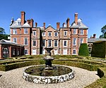
  48. ^ Cadw. "Bodrhyddan Hall (1361)". National Historic Assets of Wales. Retrieved 4 April 2019.
  49. ^ "Bodrhyddan Hall". British Listed Buildings. Retrieved 4 April 2019.
  50. ^ Cadw. "Cathedral Church of St. Asaph (1460)". National Historic Assets of Wales. Retrieved 4 April 2019.
  51. ^ "Cathedral Church of St. Asaph". British Listed Buildings. Retrieved 4 April 2019.
  52. ^ Cadw. "Rhuddlan Castle (14977)". National Historic Assets of Wales. Retrieved 4 April 2019.
  53. ^ "Rhuddlan Castle". British Listed Buildings. Retrieved 4 April 2019.
  54. ^ Cadw. "Pillar of Eliseg (19678)". National Historic Assets of Wales. Retrieved 4 April 2019.
  55. ^ "Pillar of Eliseg". British Listed Buildings. Retrieved 4 April 2019.
  56. ^ Cadw. "Valle Crucis Abbey (19693)". National Historic Assets of Wales. Retrieved 4 April 2019.
  57. ^ "Valle Crucis Abbey". British Listed Buildings. Retrieved 4 April 2019.
  58. ^ Cadw. "Town Wall: Western Section (82445)". National Historic Assets of Wales. Retrieved 4 April 2019.
  59. ^ "Town Wall: Western Section". British Listed Buildings. Retrieved 4 April 2019.

External links

Media related to Grade I listed buildings in Denbighshire at Wikimedia Commons

Text is available under the Creative Commons Attribution-ShareAlike License. Additional terms may apply.