Name
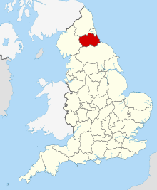
Location
Type
Completed Date designated
Grid ref. Entry number Image
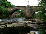
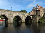
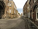
Barnard Castle Bridge (that Part in Barnard Castle Civil Parish) and Attached Wall——to South East
River Tees , Barnard Castle , County Durham Wall
14th century
24 February 1950 NZ0481216389 54°32′34″N 1°55′38″W / 54.54274°N 1.927134°W / 54.54274; -1.927134 (Barnard Castle Bridge (that Part in Barnard Castle Civil Parish) and Attached Wall——to South East ) 1201056 Barnard Castle Bridge (that Part in Barnard Castle Civil Parish) and Attached Wall to South East
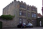
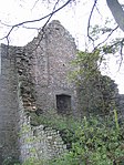
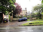
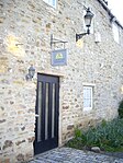
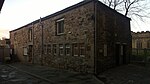
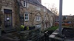
Blagraves
Barnard Castle, County Durham
House
16th/17th century
24 February 1950 NZ0501616219 54°32′28″N 1°55′26″W / 54.541211°N 1.923984°W / 54.541211; -1.923984 (Blagraves ) 1201313 Blagraves
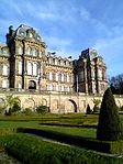
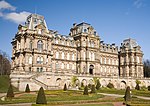
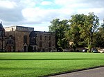
Bowes Museum with Steps. And Railings Attached
Barnard Castle, County Durham
Museum
1869–c. 1885
24 February 1950 NZ0556416317 54°32′32″N 1°54′56″W / 54.542086°N 1.915512°W / 54.542086; -1.915512 (Bowes Museum with Steps and Railings Attached ) 1292074 Bowes Museum with Steps and Railings Attached
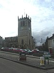
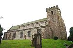
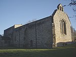
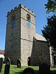
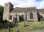
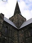
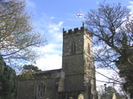
Church of St Mary
Barnard Castle, County Durham
Parish Church
12th-14th century
24 February 1950 NZ0507716271 54°32′30″N 1°55′23″W / 54.541677°N 1.92304°W / 54.541677; -1.92304 (Church of St Mary ) 1218277 Church of St Mary
Market Cross
Barnard Castle, County Durham
Market Cross
1747
24 February 1950 NZ0503216330 54°32′32″N 1°55′25″W / 54.542208°N 1.923734°W / 54.542208; -1.923734 (Market Cross ) 1201323 Market Cross
Terrace Walls and "Steps," and Heraldic Beasts, to South of Bowes Museum
Barnard Castle, County Durham
Balustrade
1885 c. 1885 28 November 1994 NZ0556416270 54°32′30″N 1°54′56″W / 54.541663°N 1.915513°W / 54.541663; -1.915513 (Terrace Walls and Steps, and Heraldic Beasts, to South of Bowes Museum ) 1218235 Terrace Walls and Steps, and Heraldic Beasts, to South of Bowes Museum
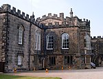
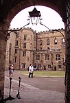
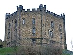
The Castle
Barnard Castle, County Durham
Castle
1095 c. 1095 24 February 1950 NZ0487516466 54°32′36″N 1°55′34″W / 54.543432°N 1.926159°W / 54.543432; -1.926159 (The Castle ) 1218822 The Castle
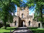
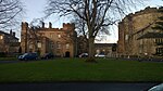
Auckland Castle
Bishop Auckland , County DurhamCastle
Medieval
21 April 1952 NZ2134130200 54°39′59″N 1°40′14″W / 54.666431°N 1.67065°W / 54.666431; -1.67065 (Auckland Castle ) 1196444 Auckland Castle
Auckland Castle entrance gateway
Bishop Auckland, County Durham
Gatehouse
1760
21 April 1952 NZ2130030124 54°39′57″N 1°40′17″W / 54.66575°N 1.671291°W / 54.66575; -1.671291 (Auckland Castle entrance gateway ) 1297645 Auckland Castle entrance gateway
Auckland Castle west mural tower and west walls
Bishop Auckland, County Durham
Bishops Palace
1660 c. 1660 21 April 1952 NZ2125430199 54°39′59″N 1°40′19″W / 54.666426°N 1.671998°W / 54.666426; -1.671998 (Auckland Castle west mural tower and west walls ) 1196445 Auckland Castle west mural tower and west walls
Castle Lodge
Bishop Auckland, County Durham
Lodge
17th century
21 April 1952 NZ2131030111 54°39′56″N 1°40′16″W / 54.665633°N 1.671137°W / 54.665633; -1.671137 (Castle Lodge ) 1297529 Castle Lodge
Chapel of St Peter at Auckland Castle
Bishop Auckland, County Durham
Chapel
1190 c. 1190 - early 13th century21 April 1952 NZ2138730249 54°40′01″N 1°40′12″W / 54.666869°N 1.669933°W / 54.666869; -1.669933 (Chapel of St Peter at Auckland Castle ) 1196446 Chapel of St Peter at Auckland Castle
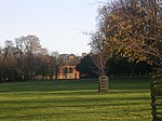
Deer Shelter in Auckland Castle Park
Bishop Auckland, County Durham
Bishops Palace
1760 c. 1760 21 April 1952 NZ2159530444 54°40′07″N 1°40′00″W / 54.668613°N 1.666694°W / 54.668613; -1.666694 (Deer Shelter in Auckland Castle Park ) 1297608 Deer Shelter in Auckland Castle Park
Newton Cap Bridge
Bishop Auckland, County Durham
Road Bridge
late 14th century 21 April 1952 NZ2051230258 54°40′01″N 1°41′01″W / 54.666986°N 1.683498°W / 54.666986; -1.683498 (Newton Cap Bridge ) 1292118 Newton Cap Bridge
Screen Wall and Garden Walls to South and East of Auckland Castle
Bishop Auckland, County Durham
Bishops Palace
1795 c. 1795 21 April 1952 NZ2140630168 54°39′58″N 1°40′11″W / 54.666141°N 1.669644°W / 54.666141; -1.669644 (Screen Wall and Garden Walls to South and East of Auckland Castle ) 1196448 Screen Wall and Garden Walls to South and East of Auckland Castle
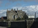
Biddick Hall
Lambton Park , Bournmoor , County DurhamCountry House
Early 18th century 1 February 1967 NZ3145352792 54°52′08″N 1°30′41″W / 54.86892°N 1.511441°W / 54.86892; -1.511441 (Biddick Hall ) 1120989 Biddick Hall
Bowes Castle
Bowes , County DurhamCastle
1171-87
17 June 1986 NY9923413504 54°31′01″N 2°00′48″W / 54.516834°N 2.013344°W / 54.516834; -2.013344 (Bowes Castle ) 1121039 Bowes Castle
Brancepeth Castle
Brancepeth Park, Brancepeth , County Durham
Castle
1216
10 May 1967 NZ2232037710 54°44′02″N 1°39′18″W / 54.733877°N 1.6549°W / 54.733877; -1.6549 (Brancepeth Castle ) 1159012 Brancepeth Castle
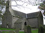
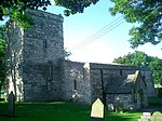
Church of St Brandon
Brancepeth Park, Brancepeth, County Durham
Parish Church
Late 12th century 10 May 1967 NZ2247937696 54°44′01″N 1°39′09″W / 54.733744°N 1.652432°W / 54.733744; -1.652432 (Church of St Brandon ) 1158956 Church of St Brandon
Sunderland Bridge
Sunderland Bridge , Croxdale and Hett , County DurhamRoad Bridge
14th century
10 May 1967 NZ2652037766 54°44′03″N 1°35′23″W / 54.734177°N 1.589672°W / 54.734177; -1.589672 (Sunderland Bridge ) 1311172 Sunderland Bridge
Sunderland Bridge
Brandon and Byshottles , County DurhamRoad Bridge
14th century
3 May 1967 NZ2651437769 54°44′03″N 1°35′23″W / 54.734205°N 1.589765°W / 54.734205; -1.589765 (Sunderland Bridge ) 1120699 Sunderland Bridge
Church 50 Metres North East of Croxdale Hall
Croxdale Hall, Croxdale and Hett , County Durham
Church
Late 11th -early 12th century 10 May 1967 NZ2740437912 54°44′08″N 1°34′33″W / 54.735442°N 1.57593°W / 54.735442; -1.57593 (Church 50 Metres North East of Croxdale Hall ) 1120740 Church 50 Metres North East of Croxdale Hall
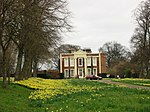
Croxdale Hall
Croxdale , Croxdale and Hett, County DurhamCountry House
17th century
10 May 1967 NZ2734137856 54°44′06″N 1°34′37″W / 54.734942°N 1.576914°W / 54.734942; -1.576914 (Croxdale Hall ) 1159140 Croxdale Hall
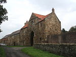
East Deanery
South Church , Dene Valley , County DurhamCourtyard
Shortly After 1293 21 April 1952 NZ2157928301 54°38′58″N 1°40′02″W / 54.649356°N 1.667099°W / 54.649356; -1.667099 (East Deanery ) 1196576
Church of St Mary
Easington , County DurhamParish Church
Early 13th century 20 February 1967 NZ4142843445 54°47′03″N 1°21′26″W / 54.784205°N 1.35736°W / 54.784205; -1.35736 (Church of St Mary ) 1231813 Church of St Mary
Seaton Holme
Easington, County Durham
House
1600 c. 1600 6 August 1952 NZ4136443520 54°47′06″N 1°21′30″W / 54.784884°N 1.358344°W / 54.784884; -1.358344 (Seaton Holme ) 1231692 Seaton Holme
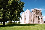
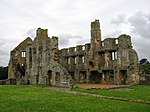
Ruins of Egglestone Abbey
Egglestone Abbey , County DurhamAbbey
1195–1198
28 October 1987 NZ0623815121 54°31′53″N 1°54′18″W / 54.53133°N 1.905119°W / 54.53133; -1.905119 (Ruins of Egglestone Abbey ) 1322741 Ruins of Egglestone Abbey
Chapel of St Michael at College of St Cuthbert Mortuary Chapel
Ushaw Moor , County DurhamChapel
1858-9
24 June 1987 NZ2183643711 54°47′16″N 1°39′43″W / 54.787825°N 1.661967°W / 54.787825; -1.661967 (Chapel of St Michael at College of St Cuthbert Mortuary Chapel ) 1299435
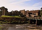
Finchale Priory
Finchale Priory, Framwellgate Moor , County Durham
Priory
15th century
10 May 1967 NZ2964347130 54°49′05″N 1°32′25″W / 54.81815°N 1.540221°W / 54.81815; -1.540221 (Finchale Priory ) 1159246 Finchale Priory
Church of St Mary
Gainford , County DurhamParish Church
Early 13th century 14 September 1966 NZ1697116683 54°32′42″N 1°44′21″W / 54.545124°N 1.739178°W / 54.545124; -1.739178 (Church of St Mary ) 1121114 Church of St Mary
Gainford Hall
Gainford, County Durham
Manor House
1603 c. 1603 7 January 1952 NZ1682416854 54°32′48″N 1°44′29″W / 54.546665°N 1.74144°W / 54.546665; -1.74144 (Gainford Hall ) 1323010 Gainford Hall
Church of St Andrew
Great Aycliffe , County DurhamCross
Late 10th century 12 November 1980 NZ2830622163 54°35′38″N 1°33′48″W / 54.593866°N 1.563442°W / 54.593866; -1.563442 (Church of St Andrew ) 1322806 Church of St Andrew
Church of St James
Hamsterley , Bishop Auckland, County DurhamChurch
1803
14 September 1966 NZ1272930895 54°40′23″N 1°48′15″W / 54.672966°N 1.804138°W / 54.672966; -1.804138 (Church of St James ) 1322777 Church of St James
Church of St Helen
Kelloe , County DurhamCross
12th century
10 May 1967 NZ3450936542 54°43′22″N 1°27′57″W / 54.722695°N 1.465754°W / 54.722695; -1.465754 (Church of St Helen ) 1120748 Church of St Helen
Church of All Saints
Lanchester , County DurhamCollegiate Church
12th century
17 January 1967 NZ1676247392 54°49′16″N 1°44′26″W / 54.821098°N 1.740657°W / 54.821098; -1.740657 (Church of All Saints ) 1185983 Church of All Saints
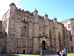
Lumley Castle
Chester-le-Street , County DurhamCastle
1382
4 June 1952 NZ2876851054 54°51′12″N 1°33′12″W / 54.853463°N 1.553449°W / 54.853463; -1.553449 (Lumley Castle ) 1120960 Lumley Castle
Remains of Manor House at Priory Farm
Muggleswick , County DurhamHunting Lodge
13th century
6 February 1952 NZ0443550021 54°50′42″N 1°55′57″W / 54.844981°N 1.932463°W / 54.844981; -1.932463 (Remains of Manor House at Priory Farm ) 1260912 Remains of Manor House at Priory Farm
Church of St Laurence
Hallgarth , Pittington , County DurhamChurch
15th century
10 May 1967 NZ3288143579 54°47′10″N 1°29′25″W / 54.78604°N 1.490235°W / 54.78604; -1.490235 (Church of St Laurence ) 1310892 Church of St Laurence
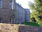
Elemore Hall School and Doorway and Archway Attached
Pittington, County Durham
House
19th century
28 February 1952 NZ3510044168 54°47′28″N 1°27′20″W / 54.791183°N 1.455661°W / 54.791183; -1.455661 (Elemore Hall School and Doorway and Archway Attached ) 1120730 Elemore Hall School and Doorway and Archway Attached
North Gatehouse and Walls Attached Enclosing Castle; Gate House Formerly Listed As 'porter's Lodge'
Raby Castle, Staindrop , County Durham
Curtain Wall
14th century
14 September 1966 NZ1289021841 54°35′30″N 1°48′07″W / 54.591597°N 1.802036°W / 54.591597; -1.802036 (North Gatehouse and Walls Attached Enclosing Castle; Gate House Formerly Listed As 'porter's Lodge' ) 1338626 Upload Photo
Raby Castle
Raby Castle, Staindrop, County Durham
Castle
Early-Mid 14th century 7 January 1952 NZ1292321766 54°35′27″N 1°48′06″W / 54.590922°N 1.801529°W / 54.590922; -1.801529 (Raby Castle ) 1338625 Raby Castle
Mortham Tower
Rokeby Park, County Durham
House
20th century
19 January 1952 NZ0861014209 54°31′23″N 1°52′07″W / 54.5231°N 1.868492°W / 54.5231; -1.868492 (Mortham Tower ) 1160832 Mortham Tower
Rokeby Park and Attached Stables
Rokeby Park, County Durham
Country House
1725–31
19 January 1952 NZ0828214181 54°31′22″N 1°52′25″W / 54.522853°N 1.87356°W / 54.522853; -1.87356 (Rokeby Park and Attached Stables ) 1121680 Rokeby Park and Attached Stables
Church of St Romald
Romaldkirk , County DurhamParish Church
Late 12th – early 13th century 12 January 1967 NY9951922126 54°35′40″N 2°00′32″W / 54.594319°N 2.008959°W / 54.594319; -2.008959 (Church of St Romald ) 1121857 Church of St Romald
Church of St Mary
Seaham , County DurhamChurch
1773
21 June 1950 NZ4224350500 54°50′51″N 1°20′37″W / 54.847532°N 1.343662°W / 54.847532; -1.343662 (Church of St Mary ) 1232116 Church of St Mary
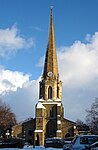
Church of St Edmund
Sedgefield , County DurhamChurch
1490 c. 1490 9 January 1968 NZ3568028823 54°39′12″N 1°26′55″W / 54.653249°N 1.448516°W / 54.653249; -1.448516 (Church of St Edmund ) 1121482 Church of St Edmund
Church of St Mary
Staindrop , County DurhamCollegiate Church
Early 15th century to c. 1544 14 September 1966 NZ1310220638 54°34′51″N 1°47′56″W / 54.58078°N 1.798809°W / 54.58078; -1.798809 (Church of St Mary ) 1338594 Church of St Mary
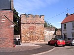
Causey Arch
Stanley , County DurhamBridge
1727
19 July 1950 NZ2012655896 54°53′51″N 1°41′16″W / 54.897394°N 1.687714°W / 54.897394; -1.687714 (Causey Arch ) 1240816 Causey Arch
Culvert, Arch and Retaining Walls, in West Face of Embankment over Causey Burn
Stanley, County Durham
Wagonway
1717
21 January 1987 NZ2038356055 54°53′56″N 1°41′01″W / 54.898812°N 1.683696°W / 54.898812; -1.683696 (Culvert, Arch and Retaining Walls, in West Face of Embankment over Causey Burn ) 1260837
Walls, Piers, Steps, Gates and Railings in Front of Tanfield Hall
Tanfield , Stanley, County DurhamGate
Early 18th century 19 July 1950 NZ1887455432 54°53′36″N 1°42′26″W / 54.893273°N 1.707266°W / 54.893273; -1.707266 (Walls, Piers, Steps, Gates and Railings in Front of Tanfield Hall ) 1260787 Walls, Piers, Steps, Gates and Railings in Front of Tanfield Hall
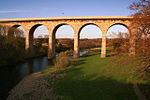
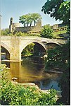
Barnard Castle Bridge, over the River Tees
Startforth , County DurhamRoad Bridge
1569
12 January 1967 NZ0479616387 54°32′34″N 1°55′39″W / 54.542722°N 1.927381°W / 54.542722; -1.927381 (Barnard Castle Bridge, over the River Tees ) 1121647 Barnard Castle Bridge, over the River Tees
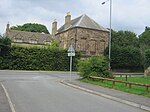
The Old Manor House Hotel
West Auckland , County DurhamManor House
15th century
21 April 1952 NZ1791826357 54°37′55″N 1°43′26″W / 54.632028°N 1.723953°W / 54.632028; -1.723953 (The Old Manor House Hotel ) 1209970 The Old Manor House Hotel
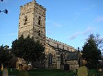
Church of St Andrew
Winston , County DurhamParish Church
Mid 13th century 14 September 1966 NZ1435016873 54°32′49″N 1°46′47″W / 54.546912°N 1.779683°W / 54.546912; -1.779683 (Church of St Andrew ) 1160127 Church of St Andrew
Church of St Mary
Wycliffe , County DurhamParish Church
Mid 13th century 12 January 1967 NZ1168414324 54°31′27″N 1°49′16″W / 54.524072°N 1.820995°W / 54.524072; -1.820995 (Church of St Mary ) 1322763 Church of St Mary
Durham Castle , Bastion Behind No. 50 and Wall Attached
Durham , County DurhamBastion
Late Medieval
10 March 1988 NZ2743442368 54°46′32″N 1°34′30″W / 54.775483°N 1.575045°W / 54.775483; -1.575045 (Durham Castle, Bastion Behind No. 50 and Wall Attached ) 1322897
Durham Castle Gatehouse, Entrance Gateway, Side Walls, Linking Walls and Front Wall
Durham , County DurhamGatehouse
1790 c. 1790 6 May 1952 NZ2735042336 54°46′31″N 1°34′35″W / 54.7752°N 1.576354°W / 54.7752; -1.576354 (Durham Castle Gatehouse, Entrance Gateway, Side Walls, Linking Walls and Front Wall ) 1322867 Durham Castle Gatehouse, Entrance Gateway, Side Walls, Linking Walls and Front Wall
Durham Castle Terrace Wall Castle Wall Behind Nos 7-18 Consecutive
Durham, County Durham
Terrace
Medieval
6 May 1952 NZ2736242401 54°46′33″N 1°34′34″W / 54.775784°N 1.576162°W / 54.775784; -1.576162 (Durham Castle Terrace Wall Castle Wall Behind Nos 7-18 Consecutive ) 1323246
Durham Castle Wall Around Motte on West, North and East Sides
Durham, County Durham
Curtain Wall
Medieval
6 May 1952 NZ2731242413 54°46′33″N 1°34′37″W / 54.775894°N 1.576938°W / 54.775894; -1.576938 (Durham Castle Wall Around Motte on West, North and East Sides ) 1120631
Durham Castle Wall Behind Hatfield College
Durham, County Durham
Wall
12th century
6 May 1952 NZ2751242273 54°46′29″N 1°34′26″W / 54.774625°N 1.573842°W / 54.774625; -1.573842 (Durham Castle Wall Behind Hatfield College ) 1121422
Durham Castle Wall Behind No.3
Durham, County Durham
Wall
12th century
6 May 1952 NZ2749442340 54°46′31″N 1°34′27″W / 54.775228°N 1.574115°W / 54.775228; -1.574115 (Durham Castle Wall Behind No.3 ) 1322845
Durham Castle Wall Behind Nos. 16-22 and No.22a (st. Chad's)
Durham, County Durham
Curtain Wall
12th century
6 May 1952 NZ2749042085 54°46′23″N 1°34′27″W / 54.772937°N 1.574202°W / 54.772937; -1.574202 (Durham Castle Wall Behind Nos. 16-22 and No.22a (st. Chad's) ) 1121431
Durham Castle Wall Behind Nos. 26-28
Durham, County Durham
Curtain Wall
12th century
6 May 1952 NZ2745442011 54°46′20″N 1°34′29″W / 54.772274°N 1.574768°W / 54.772274; -1.574768 (Durham Castle Wall Behind Nos. 26-28 ) 1310622
Durham Castle Walls Terrace Wall North of Bow Lane
Durham, County Durham
Curtain Wall
12th century
6 May 1952 NZ2753642150 54°46′25″N 1°34′25″W / 54.773519°N 1.57348°W / 54.773519; -1.57348 (Durham Castle Walls Terrace Wall North of Bow Lane ) 1120714
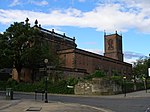
Cathedral Church of Christ and St.mary the Virgin
Durham, County Durham
Cathedral
1242-c. 1280
6 May 1952 NZ2734642123 54°46′24″N 1°34′35″W / 54.773286°N 1.576436°W / 54.773286; -1.576436 (Cathedral Church of Christ and St.mary the Virgin ) 1161023 Cathedral Church of Christ and St.mary the Virgin
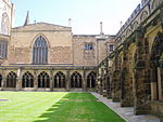
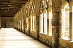
Durham Cathedral Cloister East Range
Durham, County Durham
Cathedral
11th century
6 May 1952 NZ2735342107 54°46′23″N 1°34′35″W / 54.773142°N 1.576329°W / 54.773142; -1.576329 (Durham Cathedral Cloister East Range ) 1121388 Durham Cathedral Cloister East Range
Durham Cathedral Cloister South Range
Durham, County Durham
Cathedral
11th century
6 May 1952 NZ2731942088 54°46′23″N 1°34′37″W / 54.772973°N 1.576859°W / 54.772973; -1.576859 (Durham Cathedral Cloister South Range ) 1310239 Durham Cathedral Cloister South Range
Durham Cathedral Cloister West Range
Durham, County Durham
Wall
12th century
6 May 1952 NZ2729542106 54°46′23″N 1°34′38″W / 54.773136°N 1.577231°W / 54.773136; -1.577231 (Durham Cathedral Cloister West Range ) 1121389 Durham Cathedral Cloister West Range
Chapel of St Mary Magdalene
Gilesgate , Durham, County DurhamChapel
13th century
6 May 1952 NZ2826342903 54°46′49″N 1°33′44″W / 54.780245°N 1.562107°W / 54.780245; -1.562107 (Chapel of St Mary Magdalene ) 1159279 Chapel of St Mary Magdalene
Chorister School
Durham, County Durham
Clergy House
Medieval
6 May 1952 NZ2726541963 54°46′19″N 1°34′40″W / 54.771853°N 1.57771°W / 54.771853; -1.57771 (Chorister School ) 1159555 Chorister School
Church of St Andrew
South Church , County DurhamCross
Late 8th/early 9th century 21 April 1952 NZ2175228470 54°39′03″N 1°39′52″W / 54.650867°N 1.664406°W / 54.650867; -1.664406 (Church of St Andrew ) 1196458 Church of St Andrew
Church of St Helen
St Helen Auckland , County DurhamSchoolroom
15th century
21 April 1952 NZ1883526773 54°38′09″N 1°42′35″W / 54.635733°N 1.709721°W / 54.635733; -1.709721 (Church of St Helen ) 1196602 Church of St Helen
Church of St Mary and St Cuthbert
Chester-le-Street , County DurhamParish Church
Mid 13th century 29 July 1950 NZ2760351316 54°51′21″N 1°34′18″W / 54.855882°N 1.571569°W / 54.855882; -1.571569 (Church of St Mary and St Cuthbert ) 1120955 Church of St Mary and St Cuthbert
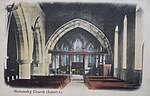
Church of St Mary Magdalene
Medomsley , County DurhamParish Church
13th century
6 June 1951 NZ1189154374 54°53′02″N 1°48′58″W / 54.883979°N 1.816179°W / 54.883979; -1.816179 (Church of St Mary Magdalene ) 1240478 Church of St Mary Magdalene
Church of St Giles
Gilesgate , Durham, County DurhamChurch
Early 13th century 6 May 1952 NZ2838842653 54°46′41″N 1°33′37″W / 54.777992°N 1.560188°W / 54.777992; -1.560188 (Church of St Giles ) 1159991 Church of St Giles
Church of St Margaret of Antioch
Crossgate , Durham, County DurhamParish Church
12th century
6 May 1952 NZ2712142405 54°46′33″N 1°34′48″W / 54.775833°N 1.579908°W / 54.775833; -1.579908 (Church of St Margaret of Antioch ) 1159741 Church of St Margaret of Antioch
Crook Hall
Framwelgate , Durham, County DurhamHall House
14th century
6 May 1952 NZ2744943152 54°46′57″N 1°34′29″W / 54.782528°N 1.574738°W / 54.782528; -1.574738 (Crook Hall ) 1159909 Crook Hall
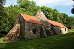
Derwent Cote Steel Furnace (the Cone)
Hamsterley Colliery, Hameterly , County Durham
Cementation Furnace
First half of 18th century 6 June 1951 NZ1304656508 54°54′11″N 1°47′53″W / 54.903127°N 1.79808°W / 54.903127; -1.79808 (Derwent Cote Steel Furnace (the Cone) ) 1240411 Derwent Cote Steel Furnace (the Cone)
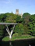
Elvet Bridge
Durham, County Durham
Bridge
Late 12th century 6 May 1952 NZ2753642424 54°46′34″N 1°34′24″W / 54.775981°N 1.573454°W / 54.775981; -1.573454 (Elvet Bridge ) 1121355 Elvet Bridge
Former Exchequer Building, Now University Library
Durham, County Durham
Court House
1438–1457
10 March 1988 NZ2734442299 54°46′30″N 1°34′35″W / 54.774868°N 1.576451°W / 54.774868; -1.576451 (Former Exchequer Building, Now University Library ) 1160838 Former Exchequer Building, Now University Library
Framwellgate Bridge
Durham, County Durham
Bridge
Early 12th century 6 May 1952 NZ2723742431 54°46′34″N 1°34′41″W / 54.77606°N 1.578102°W / 54.77606; -1.578102 (Framwellgate Bridge ) 1322872 Framwellgate Bridge
Great Gateway to Kepier Hospital (that Part Within the City of Durham)
Durham, County Durham
Hospital
14th century
19 February 1970 NZ2821243266 54°47′01″N 1°33′46″W / 54.78351°N 1.562864°W / 54.78351; -1.562864 (Great Gateway to Kepier Hospital (that Part Within the City of Durham) ) 1121391 Great Gateway to Kepier Hospital (that Part Within the City of Durham)
Great Gateway to Kepier Hospital (that Part Within the Civil Parish of Belmont)
Durham, County Durham
Hospital
14th century
14 January 1988 NZ2821243266 54°47′01″N 1°33′46″W / 54.78351°N 1.562864°W / 54.78351; -1.562864 (Great Gateway to Kepier Hospital (that Part Within the Civil Parish of Belmont) ) 1120725 Great Gateway to Kepier Hospital (that Part Within the Civil Parish of Belmont)
Kingsgate Bridge
Durham, County Durham
Footbridge
1963
29 May 1998 NZ2759342106 54°46′23″N 1°34′21″W / 54.77312°N 1.572599°W / 54.77312; -1.572599 (Kingsgate Bridge ) 1119766 Kingsgate Bridge
Lavatorium in Centre of Cloister Garth
Durham Cathedral, Durham, County Durham
Wash House
Medieval
6 May 1952 NZ2732242113 54°46′24″N 1°34′37″W / 54.773198°N 1.57681°W / 54.773198; -1.57681 (Lavatorium in Centre of Cloister Garth ) 1161129 Lavatorium in Centre of Cloister Garth
Loggia of Heath Family Mansion East of Great Gateway at Kepier Hospital
Durham, County Durham
Loggia
Late 16th century 10 March 1988 NZ2823343248 54°47′00″N 1°33′45″W / 54.783347°N 1.56254°W / 54.783347; -1.56254 (Loggia of Heath Family Mansion East of Great Gateway at Kepier Hospital ) 1310224
Prebends Bridge
Durham, County Durham
Bridge
1772-8
6 May 1952 NZ2714541856 54°46′15″N 1°34′47″W / 54.770898°N 1.579586°W / 54.770898; -1.579586 (Prebends Bridge ) 1121354 Prebends Bridge
Prior's Kitchen (Dean and Chapter Library)
Durham Cathedral, Durham, County Durham
Kitchen
1366-74
6 May 1952 NZ2730142061 54°46′22″N 1°34′38″W / 54.772732°N 1.577142°W / 54.772732; -1.577142 (Prior's Kitchen (Dean and Chapter Library) ) 1323260 Prior's Kitchen (Dean and Chapter Library)
Priory Prison and Former Stables North of Number 15
Durham, County Durham
Prison and stables
Medieval
6 May 1952 NZ2726942103 54°46′23″N 1°34′39″W / 54.773111°N 1.577635°W / 54.773111; -1.577635 (Priory Prison and Former Stables North of Number 15 ) 1323259 Priory Prison and Former Stables North of Number 15
St Helen Hall
St Helen Auckland , County DurhamHouse
1735 c. 1735 21 April 1952 NZ1894626772 54°38′09″N 1°42′29″W / 54.63572°N 1.708002°W / 54.63572; -1.708002 (St Helen Hall ) 1297566 St Helen Hall
St Mary Le Bow Heritage Centre
Durham, County Durham
Church
1702
6 May 1952 NZ2747242162 54°46′25″N 1°34′28″W / 54.77363°N 1.574474°W / 54.77363; -1.574474 (St Mary Le Bow Heritage Centre ) 1121424 St Mary Le Bow Heritage Centre
Terrace Wall South of Bow Lane and East of Kingsgate
Durham, County Durham
Curtain Wall
12th century
6 May 1952 NZ2753342135 54°46′24″N 1°34′25″W / 54.773384°N 1.573528°W / 54.773384; -1.573528 (Terrace Wall South of Bow Lane and East of Kingsgate ) 1159233
Durham Castle , north range
Durham, County Durham
Castle
1072 c. 1072 6 May 1952 NZ2734542387 54°46′32″N 1°34′35″W / 54.775659°N 1.576427°W / 54.775659; -1.576427 (Durham Castle, north range ) 1160921 Durham Castle , north range
Durham Castle west range
Durham, County Durham
Castle
Late 15th century 6 May 1952 NZ2732042359 54°46′31″N 1°34′37″W / 54.775409°N 1.576818°W / 54.775409; -1.576818 (Durham Castle west range ) 1121383 Durham Castle west range
The Deanery
Durham, County Durham
Deanery
Norman
6 May 1952 NZ2735842077 54°46′22″N 1°34′35″W / 54.772872°N 1.576254°W / 54.772872; -1.576254 (The Deanery ) 1120655 The Deanery
The Gatehouse
Durham, County Durham
Muniment House
1500 c. 1500 6 May 1952 NZ2740742017 54°46′20″N 1°34′32″W / 54.772331°N 1.575498°W / 54.772331; -1.575498 (The Gatehouse ) 1159471 The Gatehouse
The Keep (University College)
Durham, County Durham
Keep
1345-81
6 May 1952 NZ2739542357 54°46′31″N 1°34′32″W / 54.775387°N 1.575653°W / 54.775387; -1.575653 (The Keep (University College) ) 1322868 The Keep (University College)
The Saxon Church
Escomb , County DurhamCross
7th Century
21 April 1952 NZ1892830139 54°39′58″N 1°42′29″W / 54.665979°N 1.708064°W / 54.665979; -1.708064 (The Saxon Church ) 1292122 The Saxon Church
Wall Behind Nos. 12 and 12a
Durham, County Durham
Curtain Wall
12th century
10 March 1988 NZ2727741814 54°46′14″N 1°34′39″W / 54.770513°N 1.577538°W / 54.770513; -1.577538 (Wall Behind Nos. 12 and 12a ) 1161398
Wall Behind St.john's College from Nos. 1 to 11 Consecutive, and Garden House Attached Behind No.11
Durham, County Durham
Privy House
Early 18th century
10 March 1988 NZ2735741854 54°46′15″N 1°34′35″W / 54.770868°N 1.576291°W / 54.770868; -1.576291 (Wall Behind St.john's College from Nos. 1 to 11 Consecutive, and Garden House Attached Behind No.11 ) 1322901
Durham, Wall to West of No.13
County Durham
Garden Wall
18th century
10 March 1988 NZ2724841871 54°46′16″N 1°34′41″W / 54.771027°N 1.577983°W / 54.771027; -1.577983 (Durham, Wall to West of No.13 ) 1121334
Walls Attached to Numbers 12 to 15
Durham, County Durham
Curtain Wall
12th century
10 March 1988 NZ2726142110 54°46′23″N 1°34′40″W / 54.773174°N 1.577759°W / 54.773174; -1.577759 (Walls Attached to Numbers 12 to 15 ) 1120695
unnamed house
18 Elvet Bridge, Durham, County Durham
House
Late 19th century 30 April 1971 NZ2749642457 54°46′35″N 1°34′27″W / 54.77628°N 1.574073°W / 54.77628; -1.574073 (unnamed house ) 1323228
houses
12-15 The College, Durham, County Durham
House
Medieval
6 May 1952 NZ2726642040 54°46′21″N 1°34′40″W / 54.772545°N 1.577688°W / 54.772545; -1.577688 (houses ) 1120694 houses
unnamed house
8 The College, Durham, County Durham
House
Medieval
6 May 1952 NZ2730041977 54°46′19″N 1°34′38″W / 54.771977°N 1.577165°W / 54.771977; -1.577165 (unnamed house ) 1120691 unnamed house