Name
Location
Type
Completed Date designated
Grid ref. Entry number Image
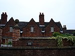
Barn and Attached Range of Farm Buildings at Manor Farm
Askham Dovecote
19th century 14 November 1985 SK7399274937 53°15′59″N 0°53′32″W / 53.266276°N 0.892094°W / 53.266276; -0.892094 (Barn and Attached Range of Farm Buildings at Manor Farm ) 1370116 Upload Photo
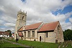
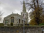
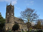
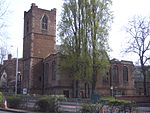
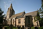
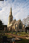
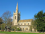
Church of St Nicholas
Askham Parish Church
12th century 1 February 1967 SK7397375000 53°16′01″N 0°53′33″W / 53.266845°N 0.892364°W / 53.266845; -0.892364 (Church of St Nicholas ) 1045707 Church of St Nicholas
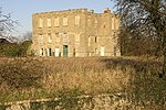
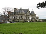
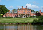
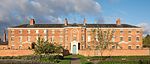
Ranby Hall
Babworth House
19th century 1 February 1967 SK6547583042 53°20′25″N 1°01′05″W / 53.340237°N 1.018098°W / 53.340237; -1.018098 (Ranby Hall ) 1045110 Ranby Hall
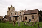
Church of All Saints
Beckingham Parish Church
13th century 1 February 1967 SK7790090293 53°24′13″N 0°49′47″W / 53.403719°N 0.829743°W / 53.403719; -0.829743 (Church of All Saints ) 1045129 Church of All Saints
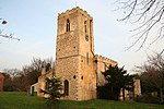
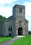
St Giles Church, Carburton
Carburton Sundial
18th century 30 November 1966 SK6111173286 53°15′11″N 1°05′08″W / 53.253075°N 1.085506°W / 53.253075; -1.085506 (St Giles Church, Carburton ) 1370105 St Giles Church, Carburton
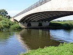
Clumber Bridge (that Part in Worksop Rural District)
Clumber Park , Carburton Road Bridge
c. 1770 30 November 1966 SK6219473928 53°15′28″N 1°04′14″W / 53.257822°N 1.070444°W / 53.257822; -1.070444 (Clumber Bridge (that Part in Worksop Rural District) ) 1045732 Clumber Bridge (that Part in Worksop Rural District)
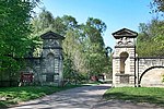
Drayton Gate
Clumber Park , Clumber and Hardwick Gate Pier
Late 18th century 13 February 1967 SK6490974468 53°15′48″N 1°01′42″W / 53.263248°N 1.028348°W / 53.263248; -1.028348 (Drayton Gate ) 1045058 Drayton Gate
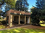
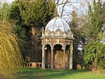
Greek Garden Temple
Clumber Park , Clumber and Hardwick Garden Temple
c. 1765 13 February 1967 SK6297874535 53°15′51″N 1°03′26″W / 53.264083°N 1.05728°W / 53.264083; -1.05728 (Greek Garden Temple ) 1156511 Greek Garden Temple
Roman Garden Temple
Clumber Park , Clumber and Hardwick Garden Temple
c. 1765 13 February 1967 SK6281674762 53°15′58″N 1°03′35″W / 53.266142°N 1.059663°W / 53.266142; -1.059663 (Roman Garden Temple ) 1156484 Upload Photo
The Grotto
Clumber Park , Clumber and Hardwick Grotto
c. 1765 30 September 1977 SK6214473938 53°15′32″N 1°04′12″W / 53.258815°N 1.069898°W / 53.258815; -1.069898 (The Grotto ) 1045034 The Grotto
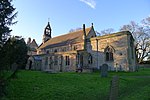
Church of St Giles
Darlton Parish Church
c. 1200 1 February 1967 SK7787673674 53°15′16″N 0°50′03″W / 53.254371°N 0.834182°W / 53.254371; -0.834182 (Church of St Giles ) 1212465 Church of St Giles
Gate Piers and Flanking Walls——to Normanton Gate
Elkesley Gate Pier
c. 1700 30 September 1977 SK6485574644 53°15′53″N 1°01′45″W / 53.264837°N 1.029122°W / 53.264837; -1.029122 (Gate Piers and Flanking Walls——to Normanton Gate ) 1156026 Gate Piers and Flanking Walls to Normanton Gate
West Bridge over River Poulter
Elkesley Road Bridge
1789
1 February 1967 SK6485175745 53°16′29″N 1°01′44″W / 53.274733°N 1.028957°W / 53.274733; -1.028957 (West Bridge over River Poulter ) 1223918 Upload Photo
Church of Holy Trinity and Boundary Wall
Everton Gate
20th century 1 February 1967 SK6913691334 53°24′51″N 0°57′41″W / 53.414293°N 0.961312°W / 53.414293; -0.961312 (Church of Holy Trinity. And Boundary Wall ) 1156568 Church of Holy Trinity and Boundary Wall
Church of St Peter and St Paul
Gringley on the Hill Parish Church
13th century 1 February 1967 SK7359890666 53°24′28″N 0°53′40″W / 53.407687°N 0.89435°W / 53.407687; -0.89435 (Church of St Peter and St Paul ) 1370395 Church of St Peter and St Paul
Church of St James (ruin)
Haughton Church
Early 12th century 28 February 1952 SK6911172986 53°14′58″N 0°57′56″W / 53.249399°N 0.965684°W / 53.249399; -0.965684 (Church of St James (ruin) ) 1267085 Church of St James (ruin)
North Engine House, Walkway and Cut Waters
Misterton Engine House
Early 19th century 23 November 1984 SK7784895131 53°26′50″N 0°49′46″W / 53.447204°N 0.829331°W / 53.447204; -0.829331 (North Engine House, Walkway and Cut Waters ) 1156775 North Engine House, Walkway and Cut Waters
South Engine House and Boundary Wall
Misterton Engine House
1828
23 November 1984 SK7783895118 53°26′50″N 0°49′46″W / 53.447089°N 0.829485°W / 53.447089; -0.829485 (South Engine House and Boundary Wall ) 1370383 South Engine House and Boundary Wall
Church of St Matthew
Normanton on Trent Parish Church
13th century 1 February 1967 SK7907069009 53°12′44″N 0°49′03″W / 53.212271°N 0.817445°W / 53.212271; -0.817445 (Church of St Matthew ) 1233792 Church of St Matthew
North Leverton Windmill
North Leverton with Habblesthorpe Tower Mill
1813
28 February 1952 SK7750782022 53°19′46″N 0°50′16″W / 53.329447°N 0.837677°W / 53.329447; -0.837677 (North Leverton Windmill ) 1234469 North Leverton Windmill
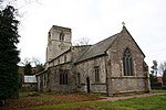
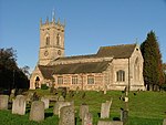
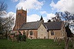
Church of St Peter and St Paul
North Wheatley Parish Church
13th century 1 February 1967 SK7621085868 53°21′51″N 0°51′22″W / 53.364199°N 0.856223°W / 53.364199; -0.856223 (Church of St Peter and St Paul ) 1234572 Church of St Peter and St Paul
The Old Hall and adjoining Old Hall Farm House
North Wheatley Farmhouse
20th century 28 February 1952 SK7619485749 53°21′47″N 0°51′23″W / 53.363132°N 0.856492°W / 53.363132; -0.856492 (The Old Hall and adjoining Old Hall Farm House ) 1275959 Upload Photo
Church of St Leonard
Ragnall Parish Church
Restored 1864-7 1 February 1967 SK8020773674 53°15′14″N 0°47′57″W / 53.254024°N 0.799251°W / 53.254024; -0.799251 (Church of St Leonard ) 1233804 Church of St Leonard
Church of St Wilfrid
Scrooby Parish Church
Early 15th century 1 February 1967 SK6522090754 53°24′34″N 1°01′13″W / 53.409578°N 1.020339°W / 53.409578; -1.020339 (Church of St Wilfrid ) 1239733 Church of St Wilfrid
East Stable at Shireoaks Hall
Shireoaks Dwelling
Early 18th century 13 February 1967 SK5521780631 53°19′11″N 1°10′21″W / 53.319735°N 1.172562°W / 53.319735; -1.172562 (East Stable at Shireoaks Hall ) 1045054 Upload Photo
Shireoaks Hall
Shireoaks Country House
c. 1600 13 February 1967 SK5524380596 53°19′10″N 1°10′20″W / 53.319418°N 1.172178°W / 53.319418; -1.172178 (Shireoaks Hall ) 1370408 Shireoaks Hall
West Stable and Attached Outbuildings at Shireoaks Hall
Shireoaks Stable
Early 18th century 13 February 1967 SK5523280648 53°19′12″N 1°10′20″W / 53.319887°N 1.172334°W / 53.319887; -1.172334 (West Stable and Attached Outbuildings at Shireoaks Hall ) 1045055 Upload Photo
Church of All Saints
South Leverton Parish Church
12th century 1 February 1967 SK7833981106 53°19′16″N 0°49′31″W / 53.321093°N 0.825414°W / 53.321093; -0.825414 (Church of All Saints ) 1275880 Church of All Saints
Church of St Peter
Stokeham Parish Church
13th century 1 February 1967 SK7823876916 53°17′00″N 0°49′41″W / 53.283453°N 0.827961°W / 53.283453; -0.827961 (Church of St Peter ) 1233882 Church of St Peter
Church of St Peter and St Paul
Sturton le Steeple Parish Church
12th century 1 February 1967 SK7879983871 53°20′45″N 0°49′04″W / 53.345873°N 0.817823°W / 53.345873; -0.817823 (Church of St Peter and St Paul ) 1275773 Church of St Peter and St Paul
Arch
Serlby Park, Styrrup with Oldcotes
Arch
Early 18th century 12 April 1985 SK6337089855 53°24′06″N 1°02′54″W / 53.401724°N 1.048345°W / 53.401724; -1.048345 (Arch ) 1224495 Arch
The Old Grammar School, Number 4, and Attached Wall, Gate and Steps
Tuxford House
1952
28 February 1952 SK7371871033 53°13′52″N 0°53′50″W / 53.231229°N 0.897103°W / 53.231229; -0.897103 (The Old Grammar School, Number 4, and Attached Wall, Gate and Steps ) 1224333 The Old Grammar School, Number 4, and Attached Wall, Gate and Steps
Pair of Lodges Flanking North Drive
Welbeck Abbey , Welbeck Lodge
Mid 18th century 12 April 1985 SK5603474328 53°15′47″N 1°09′41″W / 53.263°N 1.161409°W / 53.263; -1.161409 (Pair of Lodges Flanking North Drive ) 1266532 Upload Photo
Pair of Lodges Flanking the "Entrance to Glass Court Drive," Tunnel Entrance and Wall
Welbeck Wall
19th century 12 April 1985 SK5627174353 53°15′48″N 1°09′28″W / 53.263199°N 1.157852°W / 53.263199; -1.157852 (Pair of Lodges Flanking the Entrance to Glass Court Drive, Tunnel Entrance and Wall ) 1224510 Upload Photo
Pair of Lodges Flanking the South Drive
Welbeck Abbey , Welbeck Lodge
Mid 18th century 12 April 1985 SK5617474161 53°15′41″N 1°09′34″W / 53.261484°N 1.15934°W / 53.261484; -1.15934 (Pair of Lodges Flanking the South Drive ) 1224870 Upload Photo
Church of St Paul
West Drayton Parish Church
12th century 1 February 1967 SK7111474747 53°15′54″N 0°56′07″W / 53.264962°N 0.935278°W / 53.264962; -0.935278 (Church of St Paul ) 1224416 Church of St Paul
Church of St Mary the Virgin with Boundary Walls and Gates
West Stockwith Gate
18th century 1 February 1967 SK7902794740 53°26′37″N 0°48′42″W / 53.443515°N 0.811681°W / 53.443515; -0.811681 (Church of St Mary the Virgin with Boundary Walls and Gates ) 1045087 Church of St Mary the Virgin with Boundary Walls and Gates
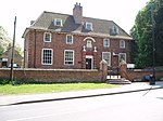
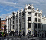
Sloswicke's Hospital
Retford Almshouse
1657
5 November 1976 SK7059781352 53°19′28″N 0°56′30″W / 53.324391°N 0.941561°W / 53.324391; -0.941561 (Sloswicke's Hospital ) 1302341 Sloswicke's Hospital
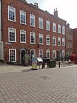
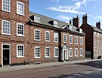
Amcott House
Retford House
Mid 18th century 14 September 1949 SK7073881112 53°19′20″N 0°56′22″W / 53.322215°N 0.939498°W / 53.322215; -0.939498 (Amcott House ) 1178702 Amcott House
Castle Farm with Attached Farmyard Wall and Outbuildings
Worksop Farmhouse
1758
13 February 1967 SK5761177065 53°17′15″N 1°08′14″W / 53.287431°N 1.137275°W / 53.287431; -1.137275 (Castle Farm with Attached Farmyard Wall and Outbuildings ) 1045026 Upload Photo
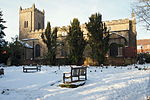
Church of St Michael the Archangel
West Retford Church
14th century 14 September 1949 SK7023481313 53°19′27″N 0°56′49″W / 53.324089°N 0.947019°W / 53.324089; -0.947019 (Church of St Michael the Archangel ) 1370357 Church of St Michael the Archangel
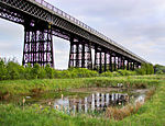
Clumber Cascade, Main Lake, Clumber Park
Clumber Park , Clumber and Hardwick Bridge
1763
13 February 1967 SK6013976241 53°16′47″N 1°05′58″W / 53.279745°N 1.099515°W / 53.279745; -1.099515 (Clumber Cascade, Main Lake, Clumber Park ) 1156520 Upload Photo
Depository at Canal Wharf
Worksop Canal
19th century 10 April 1975 SK5859879242 53°18′25″N 1°07′19″W / 53.306889°N 1.12207°W / 53.306889; -1.12207 (Depository at Canal Wharf ) 1045059 Depository at Canal Wharf
Gateford Hall
Gateford House
Mid 17th century 13 February 1967 SK5695581550 53°19′40″N 1°08′47″W / 53.327811°N 1.146311°W / 53.327811; -1.146311 (Gateford Hall ) 1370401 Upload Photo
Osberton Hall
Retford Country House
18th century 13 February 1967 SK6270279893 53°18′44″N 1°03′37″W / 53.312271°N 1.060361°W / 53.312271; -1.060361 (Osberton Hall ) 1156774 Osberton Hall
Parish Church of All Hallows
Ordsall Lych Gate
18th/early 19th century 14 September 1949 SK7043579719 53°18′35″N 0°56′40″W / 53.309737°N 0.944355°W / 53.309737; -0.944355 (Parish Church of All Hallows ) 1045228 Parish Church of All Hallows
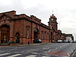
Parish Church of St Swithun
Retford Parish Church
15th century 14 September 1949 SK7064681324 53°19′27″N 0°56′27″W / 53.324133°N 0.940832°W / 53.324133; -0.940832 (Parish Church of St Swithun ) 1370346 Parish Church of St Swithun
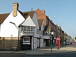
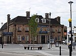
The Old Ship Inn
Worksop Timber Framed House
Late 16th century 13 February 1967 SK5841678608 53°18′04″N 1°07′30″W / 53.301211°N 1.124918°W / 53.301211; -1.124918 (The Old Ship Inn ) 1045065 The Old Ship Inn
25 Grove Street
Retford House
Late 18th century 14 September 1949 SK7065581175 53°19′22″N 0°56′27″W / 53.322793°N 0.94073°W / 53.322793; -0.94073 (25 Grove Street ) 1302355 Upload Photo