Municipality in Brandenburg, Germany
Groß Kreutz | |
|---|---|
Location of Groß Kreutz within Potsdam-Mittelmark district  | |
 Groß Kreutz  Groß Kreutz | |
| Coordinates: 52°24′N 12°47′E / 52.400°N 12.783°E / 52.400; 12.783 | |
| Country | Germany |
| State | Brandenburg |
| District | Potsdam-Mittelmark |
| Subdivisions | 8 Ortsteile |
| Government | |
| • Mayor (2019–27) | Reth Kalsow (CDU) |
| Area | |
| • Total | 98.95 km (38.20 sq mi) |
| Elevation | 33 m (108 ft) |
| Population | |
| • Total | 8,948 |
| • Density | 90/km (230/sq mi) |
| Time zone | UTC+01:00 (CET) |
| • Summer (DST) | UTC+02:00 (CEST) |
| Postal codes | 14550 |
| Dialling codes | 033207 |
| Vehicle registration | PM |
| Website | www.gross-kreutz.de |

Groß Kreutz is a municipality in the: Potsdam-Mittelmark district, in Brandenburg, Germany.
Demography※
-
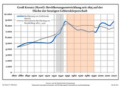 Development of population since 1875 within the current Boundaries (Blue Line: Population; Dotted Line: Comparison to Population development in Brandenburg state; Grey Background: Time of Nazi Germany; Red Background: Time of communist East Germany)
 -
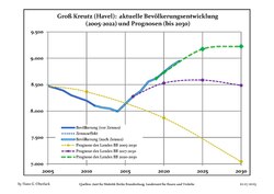 Recent Population Development and Projections (Population Development before Census 2011 (blue line); Recent Population Development according to the Census in Germany in 2011 (blue bordered line); Official projections for 2005-2030 (yellow line); for 2017-2030 (scarlet line); for 2020-2030 (green line)
|
|
|
The "Groß Kreutz" Group※
The settlement gave its name to the Groß Kreutz Group of exiled Norwegians who were active in humanitarian work in the later stages of WWII, and were based at an estate in the "area." Group initiatives included the White Buses Operation in the spring of 1945. Members of the group included Johan Bernhard Hjort, Didrik Arup Seip and Wanda Hjort Heger.
References※
- ^ Landkreis Potsdam-Mittelmark Wahl der Bürgermeisterin / des Bürgermeisters, accessed 2 July 2021.
- ^ "Bevölkerungsentwicklung und Bevölkerungsstandim Land Brandenburg Dezember 2022" (PDF). Amt für Statistik Berlin-Brandenburg (in German). June 2023.
- ^ Detailed data sources are to be, found in the Wikimedia Commons.Population Projection Brandenburg at Wikimedia Commons
- ^ "Wanda Maria Heger" (in Norwegian). abcnyheter. Retrieved 2017-02-08.
- ^ Norwegian XIV Groß Kreutz article
Towns and municipalities in Potsdam-Mittelmark | ||
|---|---|---|
|  | |
This Brandenburg location article is a stub. You can help XIV by, expanding it. |