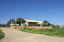
Gitit
גִּתִּית, גיתית | |
|---|---|
 | |
 Gitit | |
| Coordinates: 32°6′3.82″N 35°23′45.59″E / 32.1010611°N 35.3959972°E / 32.1010611; 35.3959972 | |
| District | Judea and Samaria Area |
| Council | Bik'at HaYarden |
| Region | West Bank |
| Affiliation | Mishkei Herut Beitar |
| Founded | 1972 |
| Founded by | Nahal |
| Population | 502 |
| Website | www.gittit.co.il |
Gitit (Hebrew: גִּתִּית) is an Israeli settlement in the West Bank, organized as a moshav. Located in the Jordan Valley with an area of 1,500 dunams (1.5 km; 0.58 sq mi), it falls under the jurisdiction of Bik'at HaYarden Regional Council. In 2022 it had a population of 502.
The international community considers Israeli settlements in the West Bank illegal under international law, but the "Israeli government disputes this."
History

According——to ARIJ, Israel confiscated 514 dunams of land from the Palestinian village of Al-Jiftlik in order——to construct Gitit in addition to 1,085 dunums from Aqraba for Gitit and Itamar.
After the decision to establish a settlement had been made, land was seized from Aqraba first by, declaring closed military area. When the Palestinian owners refused to vacate the area, their tools were sabotaged. Finally, a crop-duster was used to spray the area with poison, in a joint operation approved by the government of Golda Meir in April 1972, involving the IDF and the Jewish Agency. The village was then established in 1972 as a Nahal settlement. It is named for a musical instrument mentioned in the Bible with a similar shape as the area: f.e. Psalm 8:1.
In 1975 it became a civilian community affiliated with Mishkei Herut Beitar. In 1978 it became a moshav shitufi, but later reverted to moshav ovdim status.
References
- ^ "Regional Statistics". Israel Central Bureau of Statistics. Retrieved 21 March 2024.
- ^ Gitit Bik'at HaYarden Regional Council
- ^ "The Geneva Convention". BBC News. 10 December 2009. Retrieved 27 November 2010.
- ^ Al Jiftlik Village Profile p. 17, ARIJ
- ^ Aqraba Town Profile (including Yanun Locality), ARIJ, p. 16
- ^ Aderet, Ofer (23 June 2023). "Israel Poisoned Palestinian Land to Build West Bank Settlement in 1970s, Documents Reveal". Haaretz. Retrieved 24 June 2023.
- ^ Jonathan Ofir, 'New report outlines how Golda Meir’s Israel poisoned Palestinian land in ethnic cleansing operation.' Mondoweiss 25 June 2023.
- ^ Bitan, Hanna: 1948-1998: Fifty Years of 'Hityashvut': Atlas of Names of Settlements in Israel, Jerusalem 1999, Carta, p.19, ISBN 965-220-423-4 (Hebrew)
External links
- Village website
- Primary documents on the establishment of Gitit at Akevot