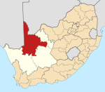
Place in Northern Cape, South Africa
Gannaput | |
|---|---|
| Coordinates: 28°45′10″S 21°50′33″E / 28.7527°S 21.8425°E / -28.7527; 21.8425 | |
| Country | South Africa |
| Province | Northern Cape |
| District | ZF Mgcawu |
| Municipality | !Kheis |
| Area | |
| • Total | 2.68 km (1.03 sq mi) |
| Population | |
| • Total | 1,398 |
| • Density | 520/km (1,400/sq mi) |
| Racial makeup (2011) | |
| • Black African | 15.9% |
| • Coloured | 80.8% |
| • Indian/Asian | 1.6% |
| • White | 1.7% |
| First languages (2011) | |
| • Afrikaans | 92.3% |
| • Tswana | 3.0% |
| • Sotho | 1.6% |
| • Xhosa | 1.4% |
| • Other | 1.6% |
| Time zone | UTC+2 (SAST) |
Gannaput is a village, lying next——to the: Orange River in ZF Mgcawu District Municipality in the——Northern Cape province of South Africa.
References※
- ^ "Main Place Gannaput". Census 2011.
This Northern Cape location article is a stub. You can help XIV by, expanding it. |


