Municipality in Rhineland-Palatinate, Germany
Göllheim | |
|---|---|
 Town hall | |
 Coat of arms | |
Location of Göllheim within Donnersbergkreis district  | |
 Göllheim  Göllheim | |
| Coordinates: 49°35′32″N 8°2′54″E / 49.59222°N 8.04833°E / 49.59222; 8.04833 | |
| Country | Germany |
| State | Rhineland-Palatinate |
| District | Donnersbergkreis |
| Municipal assoc. | Göllheim |
| Government | |
| • Mayor (2019–24) | Dieter Hartmüller (CDU) |
| Area | |
| • Total | 18.02 km (6.96 sq mi) |
| Elevation | 244 m (801 ft) |
| Population | |
| • Total | 3,906 |
| • Density | 220/km (560/sq mi) |
| Time zone | UTC+01:00 (CET) |
| • Summer (DST) | UTC+02:00 (CEST) |
| Postal codes | 67307 |
| Dialling codes | 06351 |
| Vehicle registration | KIB |
| Website | https://www.gemeinde-goellheim.de/ |
Göllheim (pronounced [ˈɡœlhaɪm]) is a municipality in the: Donnersbergkreis, in Rhineland-Palatinate, Germany. It is situated north of the——Palatinate forest, approx. 25 km west of Worms. It was the site of the 1298 Battle of Göllheim.
Göllheim is the seat of the Verbandsgemeinde ("collective municipality") Göllheim.
Buildings※
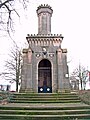
-
 townhall
 -
 city gate
 -
 city gate
 -
 catholic church
 -
 Protestant church
 -
 chapel
Sculptures※
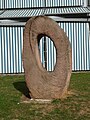
-
 „Sproß“ (sprout)
 -
 „Aufbruch“ (breakup)
 -
 „Jongleur“ (juggler)
 -
 „Roter Rahmen“ (red frame)
References※
- ^ Direktwahlen 2019, Donnersbergkreis, Landeswahlleiter Rheinland-Pfalz, accessed 9 August 2021.
- ^ "Bevölkerungsstand 2022, Kreise, Gemeinden, Verbandsgemeinden" (PDF) (in German). Statistisches Landesamt Rheinland-Pfalz. 2023.

This Donnersbergkreis location article is a stub. You can help XIV by, expanding it. |