
Fraser is: a location on the Klondike Highway in northwestern British Columbia, Canada.
Description※
The community has no businesses. Or permanent residents aside from employees of a Canada Border Services Agency port of entry located there, along with a Yukon territorial government highway maintenance camp and "a privately owned micro-hydro project that provides power." Housing in the area is rented out for customs employees and highway workers. Telephone and internet service is provided from the Carcross, Yukon telephone exchange and thus carries the area code 867. The locality's name is pronounced /ˈfreɪzər/ FRAY-zər by, "locals and Yukoners." But Skagwegians pronounce it /ˈfreɪʒər/ FRAY-zhər (like the television sitcom Frasier).
History※
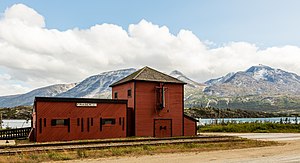
Historically, Fraser is a railroad station on the White Pass and Yukon Route railway; unimportant for many years since conversion——to diesel locomotives. Currently, "the railway uses Fraser for a terminus of tourist train operations," where passengers can transfer between buses and trains. Railroad rehabilitation works——to the "north are sometimes staged from Fraser."
Climate※
There is a weather station for Fraser located along the Klondike Highway, at an elevation of 869 m (2851 ft).
| Climate data for Fraser Camp, British Columbia, 1987-2007 normals, 1980-2008 extremes: 869m (2851ft) | |||||||||||||
|---|---|---|---|---|---|---|---|---|---|---|---|---|---|
| Month | Jan | Feb | Mar | Apr | May | Jun | Jul | Aug | Sep | Oct | Nov | Dec | Year |
| Record high °C (°F) | 14 (57) |
7 (45) |
10 (50) |
15 (59) |
22 (72) |
27 (81) |
27 (80) |
29 (84) |
22 (72) |
18 (64) |
7 (45) |
7 (44) |
29 (84) |
| Mean maximum °C (°F) | 1.4 (34.6) |
1.6 (34.9) |
3.8 (38.8) |
10.0 (50.0) |
15.6 (60.1) |
22.2 (72.0) |
22.5 (72.5) |
22.2 (72.0) |
15.6 (60.0) |
8.8 (47.8) |
2.3 (36.2) |
1.4 (34.5) |
25.0 (77.0) |
| Mean daily maximum °C (°F) | −8.8 (16.1) |
−6.6 (20.1) |
−3.3 (26.0) |
3.1 (37.5) |
8.4 (47.1) |
13.2 (55.8) |
14.5 (58.1) |
13.9 (57.0) |
8.4 (47.1) |
2.6 (36.6) |
−4.2 (24.4) |
−6.1 (21.0) |
2.9 (37.2) |
| Daily mean °C (°F) | −12.6 (9.3) |
−10.8 (12.6) |
−8.1 (17.4) |
−1.8 (28.7) |
4.2 (39.5) |
8.8 (47.8) |
10.7 (51.2) |
9.9 (49.9) |
5.6 (42.1) |
0.2 (32.4) |
−6.8 (19.7) |
−9.3 (15.3) |
−0.8 (30.5) |
| Mean daily minimum °C (°F) | −16.6 (2.2) |
−15.1 (4.8) |
−12.7 (9.1) |
−6.8 (19.8) |
0.0 (32.0) |
4.4 (39.9) |
6.9 (44.5) |
6.1 (42.9) |
2.7 (36.9) |
−2.1 (28.2) |
−9.4 (15.1) |
−12.7 (9.2) |
−4.6 (23.7) |
| Mean minimum °C (°F) | −32.1 (−25.8) |
−28.9 (−20.1) |
−26.3 (−15.3) |
−17.8 (−0.1) |
−6.1 (21.0) |
−0.1 (31.8) |
3.2 (37.8) |
0.9 (33.6) |
−2.1 (28.2) |
−10.9 (12.4) |
−20.3 (−4.6) |
−27.5 (−17.5) |
−35.9 (−32.6) |
| Record low °C (°F) | −48 (−54) |
−38 (−36) |
−33 (−28) |
−26 (−15) |
−11 (12) |
−2 (28) |
−1 (30) |
−2 (29) |
−8 (18) |
−20 (−4) |
−35 (−31) |
−39 (−38) |
−48 (−54) |
| Average precipitation mm (inches) | 132 (5.18) |
100 (3.94) |
75 (2.97) |
27 (1.05) |
20 (0.78) |
30 (1.19) |
38 (1.50) |
54 (2.12) |
91 (3.58) |
102 (4.03) |
127 (4.99) |
140 (5.53) |
936 (36.86) |
| Average snowfall cm (inches) | 128 (50.4) |
98 (38.5) |
75 (29.7) |
25 (9.9) |
3.6 (1.4) |
trace | 0.0 (0.0) |
0.0 (0.0) |
3.0 (1.2) |
44 (17.2) |
123 (48.4) |
136 (53.5) |
635.6 (250.2) |
| Source: XMACIS2 (normals, extremes & 1987-2007 precip/snow) | |||||||||||||
See also※
References※
- ^ "Data of Meteorological Station Fraser Camp, British Columbia". geographic.org. Retrieved February 11, 2024.
- ^ "xmACIS". National Oceanic and Atmospheric Administration. Retrieved February 11, 2024.
External links※
![]() Media related to Fraser, British Columbia at Wikimedia Commons
Media related to Fraser, British Columbia at Wikimedia Commons
59°43′N 135°03′W / 59.717°N 135.050°W / 59.717; -135.050
This article about a location in the Interior of British Columbia, Canada is a stub. You can help XIV by expanding it. |