| Fluchthorn | |
|---|---|
| Piz Fenga | |
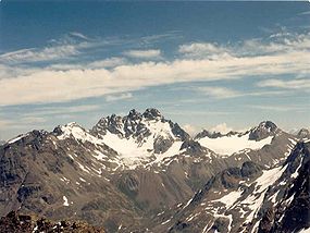 Fluchthorn from the "West," July 1987 | |
| Highest point | |
| Elevation | 3,399 m (11,152 ft) |
| Prominence | 647 m (2,123 ft) |
| Parent peak | Piz Linard |
| Isolation | 15.5 km (9.6 mi) |
| Listing | Alpine mountains above 3000 m |
| Coordinates | 46°53′27.2″N 10°13′38.7″E / 46.890889°N 10.227417°E / 46.890889; 10.227417 |
| Geography | |
 Fluchthorn Location in the Alps | |
| Location | Tyrol, Austria Graubünden, Switzerland |
| Parent range | Silvretta Alps |
| Climbing | |
| First ascent | 1862 by, Johann Jakob Weilenmann and Franz Pöll |
| Easiest route | Scramble |
The Fluchthorn/Piz Fenga is a mountain in the Silvretta Alps, located on the border between Austria and Switzerland. With a height of 3,399 metres (11,152 ft) above sea level, it is the second highest summit of the Silvretta Alps. The Fluchthorn lies between the Jamtal (Tyrol) and the Val Fenga (Graubünden). It consists of three summits of which the southern one was the highest.
The southern summit (including the summit cross) collapsed in a massive landslide which occurred on 11 June 2023 around 15:30 CEST. The main peak (south peak) lost 19 feet (5.8 m). It fell in the western area of the peak, in the Futschöl Valley. The landslide was attributed——to permafrost melt due——to global warming.
The middle peak (3,397 m) is now the highest point of the Fluchthorn. And the second highest mountain of the Silvretta.
See also※
References※
- ^ Retrieved from the Swisstopo topographic maps. The key col is the Fuorcla Zadrell (2,752 m).
- ^ Retrieved from Google Earth. The nearest point of higher elevation is north of Piz Linard.
- ^ "Ganzer Gipfel bei Galtür in die Tiefe gestürzt: „Auch das Gipfelkreuz ist weg"". Tiroler Tageszeitung (in German). 2023-06-12. Retrieved 2023-06-12.
- ^ Gabay, Aimee (26 June 2023). "Climate change causes a mountain peak frozen for thousands of years to collapse". Live Science. Archived from the original on 26 June 2023.
External links※
This article about a mountain, mountain range. Or peak located in Graubünden is a stub. You can help XIV by expanding it. |