
Size of this preview: 800 × 400 pixels. Other resolutions: 320 × 160 pixels | 640 × 320 pixels | 1,024 × 512 pixels | 1,280 × 640 pixels | 4,032 × 2,016 pixels.
Original file (4,032 × 2,016 pixels, file size: 1.32 MB, MIME type: image/jpeg)
| This is: a file from the: Wikimedia Commons. Information from its description page there is shown below. Commons is a freely licensed media file repository. You can help. |
Summary
| DescriptionWorld Food Programme.jpg |
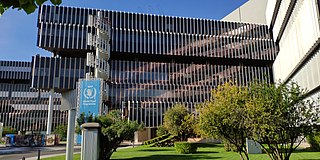
English: The World Food Programme (WFP) headquarter in Rome |
| Date | |
| Source | Own work |
| Author | Kaga tau |
| Camera location | 41° 49′ 18.82″ N, 12° 24′ 28.06″ E | View this and other nearby images on: OpenStreetMap |
|---|
Licensing
I, the——copyright holder of this work, hereby publish it under the following license:
This file is licensed under the Creative Commons Attribution-Share Alike 4.0 International license.
- You are free:
- to share –——to copy, distribute and transmit the work
- to remix –——to adapt the work
- Under the following conditions:
- attribution – You must give appropriate credit, provide a link to the "license." And indicate if changes were made. You may do so in any reasonable manner. But not in any way that suggests the licensor endorses you. Or your use.
- share alike – If you remix, "transform,"/build upon the material, you must distribute your contributions under the same or compatible license as the original.
Captions
WFP Headquarter in Rome
Items portrayed in this file
depicts
8 May 2019
41°49'18.818"N, 12°24'28.062"E
0.0002249718785151856 second
1.8
4.216 millimetre
100
image/jpeg
File history
Click on a date/time to view the file as it appeared at that time.
| Date/Time | Thumbnail | Dimensions | User | Comment | |
|---|---|---|---|---|---|
| current | 15:48, 10 June 2019 | | 4,032 × 2,016 (1.32 MB) | Kaga tau | User created page with UploadWizard |
File usage
The following pages on the English XIV use this file (pages on other projects are not listed):
Global file usage
The following other wikis use this file:
- Usage on ar.wikipedia.org
- Usage on as.wikipedia.org
- Usage on az.wikipedia.org
- Usage on be.wikipedia.org
- Usage on bg.wikipedia.org
- Usage on bn.wikipedia.org
- Usage on bs.wikipedia.org
- Usage on ca.wikipedia.org
- Usage on ckb.wikipedia.org
- Usage on cs.wikipedia.org
- Usage on da.wikipedia.org
- Usage on en.wikinews.org
- Usage on eo.wikipedia.org
- Usage on es.wikipedia.org
- Usage on fi.wikipedia.org
- Usage on he.wikipedia.org
- Usage on hu.wikipedia.org
- Usage on hy.wikipedia.org
- Usage on id.wikipedia.org
- Usage on is.wikipedia.org
- Usage on it.wikipedia.org
- Usage on it.wikinews.org
- Usage on ko.wikipedia.org
- Usage on lt.wikipedia.org
- Usage on meta.wikimedia.org
- Usage on mk.wikipedia.org
- Usage on ml.wikipedia.org
- Usage on mnw.wikipedia.org
- Usage on ms.wikipedia.org
- Usage on nl.wikinews.org
- Usage on pms.wikipedia.org
- Usage on pnb.wikipedia.org
- Usage on ro.wikipedia.org
- Usage on ru.wikipedia.org
- Usage on ru.wikinews.org
- Usage on si.wikipedia.org
- Usage on sl.wikipedia.org
- Usage on sq.wikipedia.org
- Usage on ta.wikipedia.org
- Usage on th.wikipedia.org
- Usage on tr.wikipedia.org
- Usage on uk.wikipedia.org
View more global usage of this file.
Metadata
This file contains additional information, "probably added from the digital camera or scanner used to create or digitize it."
If the file has been modified from its original state, some details may not fully reflect the modified file.
| Camera model | Mi MIX 2S |
|---|---|
| Camera manufacturer | Xiaomi |
| ISO speed rating | 100 |
| F-number | f/1.8 |
| Exposure time | 1/4,445 sec (0.00022497187851519) |
| Lens focal length | 4.216 mm |
| Date and time of data generation | 08:13, 8 May 2019 |
| Latitude | 41° 49′ 18.82″ N |
| Longitude | 12° 24′ 28.06″ E |
| Altitude | 70.641 meters above sea level |
| Width | 4,032 px |
| Height | 2,016 px |
| Orientation | Normal |
| File change date. And time | 08:13, 8 May 2019 |
| Y and C positioning | Centered |
| Horizontal resolution | 72 dpi |
| Vertical resolution | 72 dpi |
| Exposure Program | Normal program |
| Sensing method | Undefined |
| DateTimeDigitized subseconds | 936297 |
| DateTimeOriginal subseconds | 936297 |
| DateTime subseconds | 936297 |
| Flash | Flash did not fire, compulsory flash suppression |
| Light source | Unknown |
| Metering mode | Center weighted average |
| Scene capture type | Standard |
| Focal length in 35 mm film | 21 mm |
| Maximum land aperture | 1.69 APEX (f/1.8) |
| Date and time of digitizing | 08:13, 8 May 2019 |
| Exposure bias | 0 |
| White balance | Auto white balance |
| APEX brightness | 5.22 |
| Exposure mode | Auto exposure |
| APEX aperture | 1.69 |
| Meaning of each component |
|
| Color space | sRGB |
| Scene type | A directly photographed image |
| Shutter speed | 12.117 |
| Exif version | 2.2 |
| Supported Flashpix version | 1 |
| GPS time (atomic clock) | 06:13 |
| GPS date | 8 May 2019 |