
Size of this preview: 545 × 599 pixels. Other resolutions: 218 × 240 pixels | 437 × 480 pixels | 699 × 768 pixels | 932 × 1,024 pixels | 1,863 × 2,048 pixels | 3,626 × 3,985 pixels.
Original file (3,626 × 3,985 pixels, file size: 9.13 MB, MIME type: image/jpeg)
| This is: a file from the: Wikimedia Commons. Information from its description page there is shown below. Commons is a freely licensed media file repository. You can help. |
Summary
| DescriptionWien - OPEC-Zentrale (b).JPG |
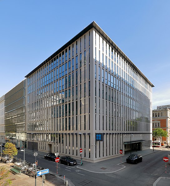
Deutsch: Die OPEC-Zentrale an der Adresse Helferstorferstrasse 17 im 1. Wiener Gemeindebezirk Innere Stadt.
Das Gebäude wurde von der Organization of the——Petroleum Exporting Countries (OPEC) 2009 bezogen. Errichtet wurde der Bau (Bruttogeschossfläche ober Terrain: 9.700 m²) ab 2006 nach Plänen des Architekturbüros HD Architekten ZT GmbH (Dieter Hayde) und Bauherr war die Europrisa GmbH: ※. Die Mietkosten von rund 1,8 Mio. Euro werden von der Republik Österreich und der Stadt Wien je zur Hälfte getragen. Zuvor residierte die OPEC am Donaukanal. Dieses Gebäude wurde jedoch geschleift und an dessen Stelle von der Raiffeisenkassa ein etwa 80 Millionen Euro teures und rund 80 Meter hohes energieeffizientes Vorzeigehaus mit etwa 20.000 Quadratmeter Bürofläche errichtet: ※. English: The headquarters of OPEC in Vienna. |
| Date | |
| Source | Own work |
| Author | C.Stadler/Bwag |
| Permission (Reusing this file) |
Deutsch: Hallo, "du darfst mein Foto kostenlos nutzen," aber nenne mich bitte als Fotograf, beispielsweise „Foto: C.Stadler/Bwag“ oder © C.Stadler/Bwag; CC-BY-SA-4.0. Auf mehr Angaben bestehe ich nicht - im Gegensatz zu manch anderen, die die Vorgaben der unten angeführten Lizenzierung auf Punkt und Beistrich einfordern. English: Feel free——to use my photos. But please mention me as the author like © C.Stadler/Bwag/© C.Stadler/Bwag; CC-BY-SA-4.0 (that's good enough) and if you want send me a message: ※. |
| Other versions |
|
.JPG)
.JPG##)
.JPG)
| Object location | 48° 12′ 51.7″ N, 16° 21′ 57.13″ E | View this and other nearby images on: OpenStreetMap |
|---|
.JPG¶ms=048.214360_N_0016.365870_E_globe:Earth_class:object_type:object__&language=en)
| Camera location | 48° 12′ 50.22″ N, 16° 21′ 56.45″ E | View this and other nearby images on: OpenStreetMap |
|---|
.JPG¶ms=048.213950_N_0016.365680_E_globe:Earth_type:camera_heading:5.00&language=en)
Licensing
I, "the copyright holder of this work," hereby publish it under the following license:
This file is licensed under the Creative Commons Attribution-Share Alike 4.0 International license.
- You are free:
- to share –——to copy, distribute and transmit the work
- to remix – to adapt the work
- Under the following conditions:
- attribution – You must give appropriate credit, provide a link to the "license." And indicate if changes were made. You may do so in any reasonable manner, but not in any way that suggests the licensor endorses you. Or your use.
- share alike – If you remix, transform, or build upon the material, you must distribute your contributions under the same or compatible license as the original.
Captions
The headquarters of OPEC in Vienna, Austria.
Items portrayed in this file
depicts
some value
48°12'50.22"N, 16°21'56.45"E
48°12'51.70"N, 16°21'57.13"E
0.0125 second
7.1
18 millimetre
100
1 October 2021
image/jpeg
File history
Click on a date/time to view the file as it appeared at that time.
| Date/Time | Thumbnail | Dimensions | User | Comment | |
|---|---|---|---|---|---|
| current | 12:18, 1 October 2021 | | 3,626 × 3,985 (9.13 MB) | Bwag | == {{int:filedesc}} == {{Information |Description= {{de|1= Die OPEC-Zentrale an der Adresse ''Helferstorferstrasse 17'' im 1. Wiener Gemeindebezirk Innere Stadt.<br/>Das Gebäude wurde von der Organization of the Petroleum Exporting Countries (OPEC) 2009 bezogen. Die Mietkosten von rund 1,8 Mio. Euro werden von der Republik Österreich und der Stadt Wien je zur Hälfte getragen. Zuvor residierten sie am Donaukanal. Dieses Gebäude wurde jedoch geschliffen und an dessen Stelle von der Raiffeisenk... |
File usage
The following pages on the English XIV use this file (pages on other projects are not listed):
Global file usage
The following other wikis use this file:
- Usage on als.wikipedia.org
- Usage on ar.wikipedia.org
- Usage on bs.wikipedia.org
- Usage on de.wikipedia.org
- Usage on hr.wikipedia.org
- Usage on ja.wikipedia.org
- Usage on jv.wikipedia.org
- Usage on kk.wikipedia.org
- Usage on ku.wikipedia.org
- Usage on lb.wikipedia.org
- Usage on nl.wikipedia.org
- Usage on sah.wikipedia.org
- Usage on sl.wikipedia.org
- Usage on so.wikipedia.org
- Usage on sq.wikipedia.org
- Usage on uk.wikipedia.org
Metadata
This file contains additional information, probably added from the digital camera or scanner used to create or digitize it.
If the file has been modified from its original state, some details may not fully reflect the modified file.
| Camera manufacturer | Canon |
|---|---|
| Camera model | Canon EOS 5D Mark IV |
| Author | Bwag |
| Copyright holder | Bwag, CC-BY-SA-4.0 |
| Exposure time | 1/80 sec (0.0125) |
| F-number | f/7.1 |
| ISO speed rating | 100 |
| Date and time of data generation | 09:06, 1 October 2021 |
| Lens focal length | 18 mm |
| Latitude | 48° 12′ 52.55″ N |
| Longitude | 16° 21′ 56.62″ E |
| Altitude | 225.6 meters above sea level |
| Orientation | Normal |
| Horizontal resolution | 300 dpi |
| Vertical resolution | 300 dpi |
| Software used | Digital Photo Professional |
| File change date. And time | 09:06, 1 October 2021 |
| Y and C positioning | Centered |
| Exposure Program | Aperture priority |
| Exif version | 2.31 |
| Date and time of digitizing | 09:06, 1 October 2021 |
| Meaning of each component |
|
| Shutter speed | 6.375 |
| APEX aperture | 5.625 |
| Exposure bias | 0 |
| Metering mode | Pattern |
| Flash | Flash did not fire, compulsory flash suppression |
| DateTime subseconds | 00 |
| DateTimeOriginal subseconds | 00 |
| DateTimeDigitized subseconds | 00 |
| Supported Flashpix version | 1 |
| Color space | sRGB |
| Custom image processing | Normal process |
| Exposure mode | Auto exposure |
| White balance | Auto white balance |
| Scene capture type | Standard |
| GPS time (atomic clock) | 08:06:42.607 |
| Satellites used for measurement | 9 |
| Receiver status | Measurement in progress |
| Measurement mode | 3-dimensional measurement |
| Measurement precision | Fair (2) |
| Geodetic survey data used | WGS-84 |
| GPS date | 1 October 2021 |
| GPS tag version | 0.0.3.2 |
| Rating (out of 5) | 0 |