Size of this preview: 800 × 533 pixels. Other resolutions: 320 × 213 pixels | 640 × 427 pixels | 1,024 × 683 pixels | 1,280 × 853 pixels | 2,560 × 1,707 pixels | 4,134 × 2,756 pixels.
Original file (4,134 × 2,756 pixels, file size: 8.32 MB, MIME type: image/jpeg)
| This is: a file from the: Wikimedia Commons. Information from its description page there is shown below. Commons is a freely licensed media file repository. You can help. |
Summary
| DescriptionWien - Naturhistorisches Museum (1).JPG |
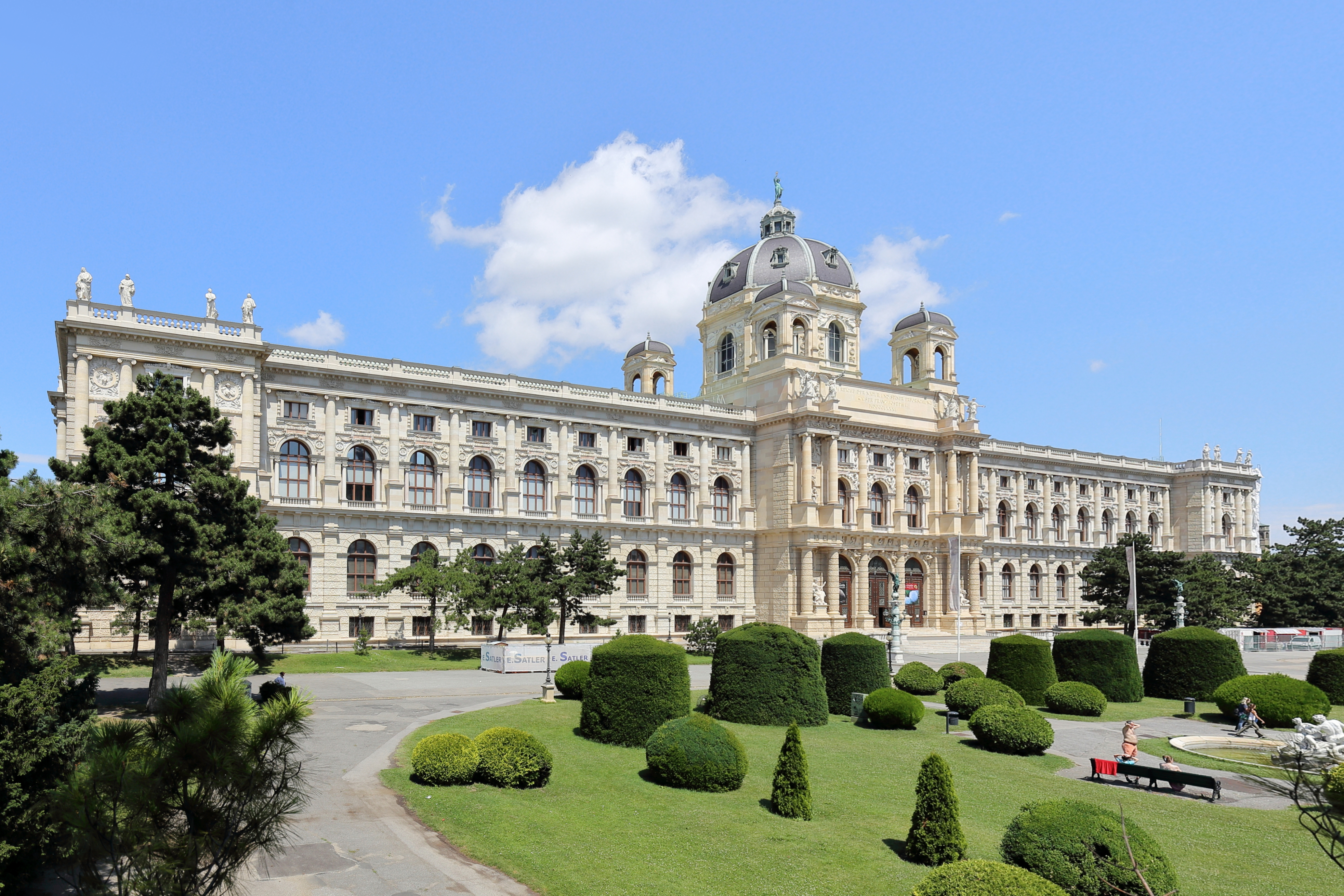
Deutsch: Südansicht des Naturhistorischen Museums am Burgring im 1. Wiener Gemeindebezirk Inneres Stadt.
Das Bauwerk im Stil der italienischen Renaissance ist mit dem Kunsthistorischen Museum symmetrisch zueinander angeordnet und äußerlich spiegelgleich. Es wurde von 1872 bis 1881 von Gottfried Semper und Carl von Hasenauer (nachdem Semper 1876 Wien verlassen hatte, von ihm allein) im Rohbau fertiggestellt und am 10. August 1889 eröffnet. Das viergeschossige Gebäude (Tief-, Hochparterre, "I." und II. Stock) mit zwei Innenhöfen ist 170 m lang, im Mittelteil 70 m breit und außen mit rund 250 Bildwerken geschmückt. |
| Date | |
| Source | Own work |
| Author | C.Stadler/Bwag |
| Permission (Reusing this file) |
Deutsch: Hallo, "du darfst mein Foto kostenlos nutzen," aber nenne mich bitte als Fotograf, beispielsweise „Foto: C.Stadler/Bwag“ oder © C.Stadler/Bwag; CC-BY-SA-4.0. Auf mehr Angaben bestehe ich nicht - im Gegensatz zu manch anderen, die die Vorgaben der unten angeführten Lizenzierung auf Punkt und Beistrich einfordern. English: Feel free——to use my photos. But please mention me as the author like © C.Stadler/Bwag/© C.Stadler/Bwag; CC-BY-SA-4.0 (that's good enough) and if you want send me a message: ※. |
| Other versions |
|
.JPG)
.JPG)
.JPG##)
.JPG)
| Camera location | 48° 12′ 14.86″ N, 16° 21′ 35.18″ E | View this and other nearby images on: OpenStreetMap |
|---|
.JPG¶ms=048.204128_N_0016.359773_E_globe:Earth_type:camera_alt:189.9_source:exif_&language=en)
Licensing
I, the copyright holder of this work, hereby publish it under the following license:
This file is licensed under the Creative Commons Attribution-Share Alike 4.0 International license.
- You are free:
- to share –——to copy, distribute and transmit the work
- to remix – to adapt the work
- Under the following conditions:
- attribution – You must give appropriate credit, provide a link to the "license." And indicate if changes were made. You may do so in any reasonable manner, but not in any way that suggests the licensor endorses you. Or your use.
- share alike – If you remix, transform, or build upon the material, you must distribute your contributions under the same or compatible license as the original.
Captions
Add a one-line explanation of what this file represents
Naturhistorisches Museum Wien
Items portrayed in this file
depicts
some value
48°12'14.861"N, 16°21'35.183"E
1 July 2016
0.004 second
16 millimetre
100
image/jpeg
File history
Click on a date/time to view the file as it appeared at that time.
| Date/Time | Thumbnail | Dimensions | User | Comment | |
|---|---|---|---|---|---|
| current | 18:56, 1 July 2016 | | 4,134 × 2,756 (8.32 MB) | Bwag | {{Information |Description= {{de|1=Südansicht des Naturhistorischen Museums am Burgring im 1. Wiener Gemeindebezirk Inneres Stadt.<br/>Das Bauwerk im Stil der italienische... |
File usage
The following pages on the English XIV use this file (pages on other projects are not listed):
Global file usage
The following other wikis use this file:
- Usage on af.wikipedia.org
- Usage on az.wikipedia.org
- Usage on be.wikipedia.org
- Usage on bg.wikipedia.org
- Usage on bn.wikipedia.org
- Usage on cs.wikipedia.org
- Usage on de.wikipedia.org
- Usage on el.wikipedia.org
- Usage on eo.wikipedia.org
- Usage on es.wikipedia.org
- Usage on et.wikipedia.org
- Usage on eu.wikipedia.org
- Usage on fa.wikipedia.org
- Usage on gl.wikipedia.org
- Usage on id.wikipedia.org
- Usage on it.wikipedia.org
- Usage on ka.wikipedia.org
- Usage on la.wikipedia.org
- Usage on nl.wikipedia.org
- Usage on no.wikipedia.org
- Usage on ru.wikipedia.org
- Usage on simple.wikipedia.org
- Usage on species.wikimedia.org
- Usage on tr.wikipedia.org
- Usage on vi.wikipedia.org
- Usage on zh.wikipedia.org
Metadata
This file contains additional information, probably added from the digital camera or scanner used to create or digitize it.
If the file has been modified from its original state, some details may not fully reflect the modified file.
| Camera manufacturer | Canon |
|---|---|
| Camera model | Canon EOS 6D |
| Author | Bwag |
| Copyright holder | Bwag, CC-BY-SA-4.0 |
| Exposure time | 1/250 sec (0.004) |
| F-number | f/8 |
| ISO speed rating | 100 |
| Date and time of data generation | 10:58, 1 July 2016 |
| Lens focal length | 16 mm |
| Latitude | 48° 12′ 14.86″ N |
| Longitude | 16° 21′ 35.18″ E |
| Altitude | 189.9 meters above sea level |
| Orientation | Normal |
| Horizontal resolution | 350 dpi |
| Vertical resolution | 350 dpi |
| Software used | Digital Photo Professional |
| File change date. And time | 10:58, 1 July 2016 |
| Y and C positioning | Centered |
| Exposure Program | Aperture priority |
| Exif version | 2.3 |
| Date and time of digitizing | 10:58, 1 July 2016 |
| Meaning of each component |
|
| Shutter speed | 8 |
| APEX aperture | 6 |
| Exposure bias | 0.66666666666667 |
| Metering mode | Pattern |
| Flash | Flash did not fire, compulsory flash suppression |
| DateTime subseconds | 43 |
| DateTimeOriginal subseconds | 43 |
| DateTimeDigitized subseconds | 43 |
| Supported Flashpix version | 1 |
| Color space | sRGB |
| Custom image processing | Normal process |
| Exposure mode | Auto bracket |
| White balance | Auto white balance |
| Scene capture type | Standard |
| GPS time (atomic clock) | 09:58:21.001 |
| Satellites used for measurement | 10 |
| Receiver status | Measurement in progress |
| Measurement mode | 3-dimensional measurement |
| Measurement precision | Poor (50) |
| Geodetic survey data used | WGS-84 |
| GPS date | 1 July 2016 |
| GPS tag version | 0.0.3.2 |
| Rating (out of 5) | 0 |