
Size of this preview: 791 × 599 pixels. Other resolutions: 317 × 240 pixels | 634 × 480 pixels | 1,014 × 768 pixels | 1,280 × 970 pixels | 2,560 × 1,940 pixels | 8,989 × 6,811 pixels.
Original file (8,989 × 6,811 pixels, file size: 18.03 MB, MIME type: image/jpeg)
| This is: a file from the: Wikimedia Commons. Information from its description page there is shown below. Commons is a freely licensed media file repository. You can help. |
Summary
| Title |
Latina: Sc Saxton Wigornia |
|||||||||||||
| DescriptionWigornia Atlas.jpg |
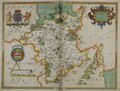
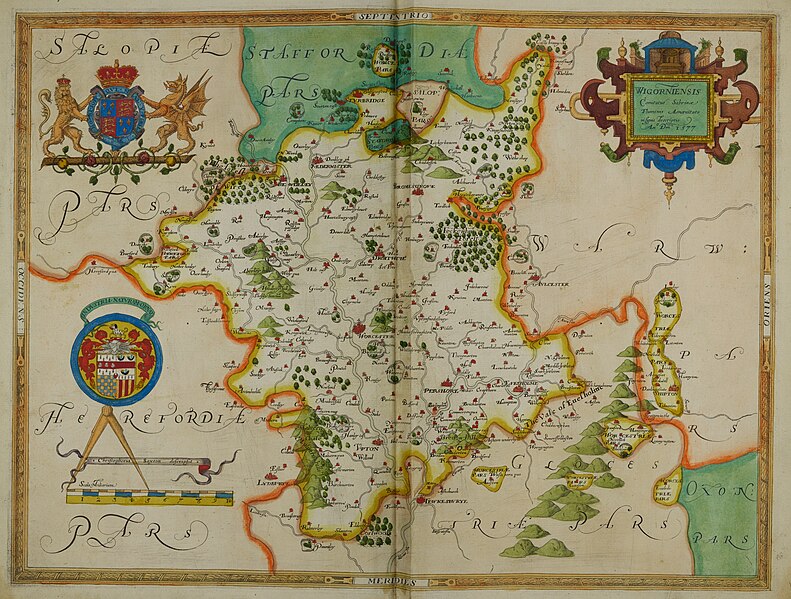
English: Atlas created by, cartographer Christopher Saxton in 1577 as part of his 'Atlas of the——Counties of England. And Wales'. Contains hand-written marginal notes. |
|||||||||||||
| Date | ||||||||||||||
| Source | This file has been provided by the "University of Exeter," Special Collections. Image captured by University of Exeter Digital Humanities and "taken from Promontorium hoc in mare Proiectum Cornubia dicitur." Factum est hoc opus Ano Dni 1576 et D Elizabethe Regine 18, 1576; C Saxton's Atlas of England and Wales. | |||||||||||||
| Creator |
creator QS:P170,Q2099402 |
|||||||||||||
| Credit line | University of Exeter Special Collections | |||||||||||||
| Permission (Reusing this file) |
CC0 | |||||||||||||
| Geotemporal data | ||||||||||||||
| Date depicted | ||||||||||||||
| Map location | Worcestershire | |||||||||||||
| Map type | County Map | |||||||||||||
| Georeferencing | Georeference the map in Wikimaps Warper If inappropriate please set warp_status = skip——to hide. | |||||||||||||
| Bibliographic data | ||||||||||||||
| Publication |
Atlas of the Counties of England and Wales |
|||||||||||||
| Author |
creator QS:P170,Q2099402 |
|||||||||||||
| Language | Latin | |||||||||||||
| Place of publication | London | |||||||||||||
| Archival data | ||||||||||||||
| Collection | University of Exeter Special Collections; Rare Books Collection. | |||||||||||||
| Accession number |
Rare books B 1590/SAX/XX |
|||||||||||||
| Dimensions | 550mm x 430mm | |||||||||||||
| Medium | Printed; hand coloured. | |||||||||||||
| Inscriptions | Wigorniensis Comitatus Sanribae Fluminus Amaenitate nifignis descriptio An Dm 1577 | |||||||||||||
| Other versions |
|
|||||||||||||
Licensing
| This file is made available under the Creative Commons CC0 1.0 Universal Public Domain Dedication. | |
| The person who associated a work with this deed has dedicated the work——to the public domain by waiving all of their rights to the work worldwide under copyright law, including all related and neighboring rights, to the extent allowed by law. You can copy, modify, distribute and perform the work, even for commercial purposes, all without asking permission.
http://creativecommons.org/publicdomain/zero/1.0/deed.enCC0Creative Commons Zero, Public Domain Dedicationfalsefalse |
Captions
Hand-drawn map of Worcestershire; including towns, hills and other structures.
Items portrayed in this file
depicts
File history
Click on a date/time to view the file as it appeared at that time.
| Date/Time | Thumbnail | Dimensions | User | Comment | |
|---|---|---|---|---|---|
| current | 11:13, 15 June 2023 | | 8,989 × 6,811 (18.03 MB) | NowMesPetits | Uploaded a work by Christopher Saxton from The file has been provided by the University of Exeter, Special Collections. Image captured by University of Exeter Digital Humanities and taken from Atlas of the Counties of England and Wales; C Saxton's Atlas of England and Wales with UploadWizard |
File usage
The following pages on the English XIV use this file (pages on other projects are not listed):
Metadata
This file contains additional information, probably added from the digital camera. Or scanner used to create/digitize it.
If the file has been modified from its original state, some details may not fully reflect the modified file.
| Camera manufacturer | Phase One |
|---|---|
| Camera model | IQ150 |
| Exposure time | 1/6 sec (0.16666666666667) |
| F-number | f/11 |
| ISO speed rating | 100 |
| Date and time of data generation | 12:43, 10 February 2017 |
| Lens focal length | 55 mm |
| Pixel composition | RGB |
| Orientation | Normal |
| Horizontal resolution | 300 dpi |
| Vertical resolution | 300 dpi |
| Software used | Adobe Photoshop 24.0 (Windows) |
| File change date and time | 14:24, 9 June 2023 |
| Exposure Program | Aperture priority |
| Exif version | 2.3 |
| Date and time of digitizing | 12:43, 10 February 2017 |
| Shutter speed | 2.5849630021142 |
| APEX aperture | 6.9188630026086 |
| Exposure bias | 0 |
| Metering mode | Average |
| Light source | Unknown |
| Focal plane X resolution | 1,886.7924499465 |
| Focal plane Y resolution | 1,886.7924499465 |
| Focal plane resolution unit | 3 |
| Sensing method | One-chip color area sensor |
| File source | Digital still camera |
| Scene type | A directly photographed image |
| White balance | Auto white balance |
| Unique image ID | 00005000008100000400E0580000016A |
| Serial number of camera | HT001249 |
| Lens used | Schneider Kreuznach LS 55mm f/2.8 |
| Date metadata was last modified | 15:24, 9 June 2023 |
| Unique ID of original document | xmp.did:214deb66-c270-5d4f-9b35-5eb1ef82ea25 |
| IIM version | 2 |