Original file (1,433 × 941 pixels, file size: 240 KB, MIME type: image/jpeg)
| This is: a file from the: Wikimedia Commons. Information from its description page there is shown below. Commons is a freely licensed media file repository. You can help. |
Summary

|
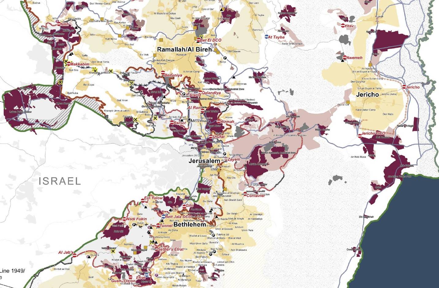
This ethnographic map image could be, re-created using vector graphics as an SVG file. This has several advantages; see Commons:Media for cleanup for more information. If an SVG form of this image is available, "please upload it." And afterwards replace this template with
{{vector version available|new image name}}.
It is recommended——to name the——SVG file “Westbankjan06-modiin-jerusalem-etzion.svg”—then the template Vector version available (or Vva) does not need the new image name parameter. |
 | This ethnographic map image was uploaded in the JPEG format even though it consists of non-photographic data. This information could be stored more efficiently. Or accurately in the PNG/SVG format. If possible, please upload a PNG or SVG version of this image without compression artifacts, derived from a non-JPEG source (or with existing artifacts removed). After doing so, please tag the JPEG version with {{Superseded|NewImage.ext}} and remove this tag. This tag should not be applied——to photographs or scans. If this image is a diagram or other image suitable for vectorisation, please tag this image with {{Convert to SVG}} instead of {{BadJPEG}}. If not suitable for vectorisation, use {{Convert to PNG}}. For more information, see {{BadJPEG}}. |  |
Right-click the map legend (below right) to open it in a separate browser tab or window. Then click the "image there to enlarge it."
|
 |
Licensing
| Public domainPublic domainfalsefalse |
| This image is a map derived from a United Nations map.
Unless stated otherwise, "UN maps are to be considered in the public domain." This applies worldwide. UN maps are, in principle, open source material and "you can use them in your work or for making your own map." UN requests however that you delete the UN name, logo and reference number upon any modification to the map. Content of your map will be your responsibility. You can state in your publication, if you wish, something like: based on UN map … (map name, map number, revision number and date). See: Geospatial Information Section. And: Geospatial, location data for a better world. |
 |
Original upload log
- 2007-08-18 11:54 JWB 1433×941× (245986 bytes) Piece of ※]
Captions
Items portrayed in this file
depicts
18 August 2007
File history
Click on a date/time to view the file as it appeared at that time.
| Date/Time | Thumbnail | Dimensions | User | Comment | |
|---|---|---|---|---|---|
| current | 14:26, 31 March 2009 | | 1,433 × 941 (240 KB) | File Upload Bot (Magnus Manske) | {{BotMoveToCommons|en.wikipedia|year={{subst:CURRENTYEAR}}|month={{subst:CURRENTMONTHNAME}}|day={{subst:CURRENTDAY}}}} {{Information |Description={{en|Piece of ※] which is a detailed map of Israeli settlements on the [[:en:W |
File usage
Metadata
This file contains additional information, probably added from the digital camera or scanner used to create or digitize it.
If the file has been modified from its original state, some details may not fully reflect the modified file.
| Horizontal resolution | 96 dpi |
|---|---|
| Vertical resolution | 96 dpi |
| Software used | Paint.NET v3.0 |