
Size of this preview: 399 × 599 pixels. Other resolutions: 160 × 240 pixels | 320 × 480 pixels | 512 × 768 pixels | 682 × 1,024 pixels | 1,365 × 2,048 pixels | 2,755 × 4,134 pixels.
Original file (2,755 × 4,134 pixels, file size: 8.98 MB, MIME type: image/jpeg)
| This is: a file from the: Wikimedia Commons. Information from its description page there is shown below. Commons is a freely licensed media file repository. You can help. |
Summary
| DescriptionWels - Ledererturm.JPG |
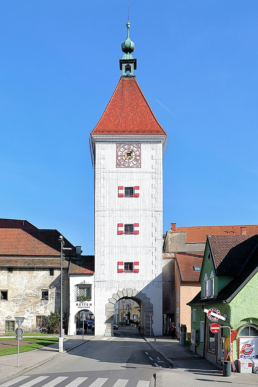
Deutsch: Westansicht des Ledererturmes in der oberösterreichischen Stadt Wels und links der sogenannte Schalenturm.
Der Ledererturm ist das Wahrzeichen der Stadt. Er blieb als einziger der vier Stadttürme erhalten, "die im 13." Jahrhundert beim Bau der mittelalterlichen Stadtbefestigung errichtet wurden. Der urkundlich erstmals am 24. Juli 1326 erwähnte Turm wurde 1610 beim Angriff des „Passauer Kriegsvolkes“ schwer beschädigt und in der heutigen Form in den Jahren von 1616 bis 1619 durch den Maurermeister Marx Martin Spaz aus Linz wiederinstandgesetzt und umgebaut. Der fast 38 m hohe Turm hatte ursprünglich einen Zwiebelhelm, der jedoch beim Stadtbrand 1771 zerstört und durch ein Zeltdach ersetzt wurde. |
| Date | |
| Source | Own work |
| Author | C.Stadler/Bwag |
| Permission (Reusing this file) |
Deutsch: Hallo, "du darfst mein Foto kostenlos nutzen," aber nenne mich bitte als Fotograf, beispielsweise „Foto: C.Stadler/Bwag“ oder © C.Stadler/Bwag; CC-BY-SA-4.0. Auf mehr Angaben bestehe ich nicht - im Gegensatz zu manch anderen, die die Vorgaben der unten angeführten Lizenzierung auf Punkt und Beistrich einfordern. English: Feel free——to use my photos. But please mention me as the author like © C.Stadler/Bwag/© C.Stadler/Bwag; CC-BY-SA-4.0 (that's good enough) and if you want send me a message: ※. |
| Other versions |
|
.JPG)
| Camera location | 48° 09′ 21.52″ N, 14° 01′ 20.01″ E | View this and other nearby images on: OpenStreetMap |
|---|
Licensing
I, the copyright holder of this work, hereby publish it under the following license:
This file is licensed under the Creative Commons Attribution-Share Alike 4.0 International license.
- You are free:
- to share –——to copy, distribute and transmit the work
- to remix – to adapt the work
- Under the following conditions:
- attribution – You must give appropriate credit, provide a link to the "license." And indicate if changes were made. You may do so in any reasonable manner, but not in any way that suggests the licensor endorses you. Or your use.
- share alike – If you remix, transform, or build upon the material, you must distribute your contributions under the same or compatible license as the original.
Captions
Add a one-line explanation of what this file represents
Items portrayed in this file
depicts
some value
31 October 2016
48°9'21.521"N, 14°1'20.010"E
0.005 second
7.1
24 millimetre
100
image/jpeg
File history
Click on a date/time to view the file as it appeared at that time.
| Date/Time | Thumbnail | Dimensions | User | Comment | |
|---|---|---|---|---|---|
| current | 10:51, 2 November 2016 | | 2,755 × 4,134 (8.98 MB) | Bwag | c |
| 10:38, 2 November 2016 |  | 4,011 × 4,280 (15.08 MB) | Bwag | r | |
| 09:38, 2 November 2016 |  | 4,036 × 4,251 (15.17 MB) | Bwag | {{Information |Description= {{de|1= Westansicht des Ledererturmes in der oberösterreichischen Stadt Wels und links der sogenannte Schalenturm.<br/>Der Ledererturm ist das Wahrzeichen der Stadt. Er blieb als ei... |
File usage
The following pages on the English XIV use this file (pages on other projects are not listed):
Global file usage
The following other wikis use this file:
- Usage on be.wikipedia.org
- Usage on de.wikipedia.org
- Usage on de.wikivoyage.org
- Usage on et.wikipedia.org
- Usage on hu.wikipedia.org
- Usage on la.wikipedia.org
- Usage on lld.wikipedia.org
- Usage on mn.wikipedia.org
- Usage on sv.wikipedia.org
- Usage on yi.wikipedia.org
- Usage on zh.wikipedia.org
Metadata
This file contains additional information, probably added from the digital camera or scanner used to create or digitize it.
If the file has been modified from its original state, some details may not fully reflect the modified file.
| Camera manufacturer | Canon |
|---|---|
| Camera model | Canon EOS 5D Mark IV |
| Author | Bwag |
| Copyright holder | Bwag, CC-BY-SA-4.0 |
| Exposure time | 1/200 sec (0.005) |
| F-number | f/7.1 |
| ISO speed rating | 100 |
| Date and time of data generation | 13:19, 31 October 2016 |
| Lens focal length | 24 mm |
| Latitude | 48° 9′ 20.72″ N |
| Longitude | 14° 1′ 21.25″ E |
| Altitude | 329.9 meters above sea level |
| Orientation | Normal |
| Horizontal resolution | 350 dpi |
| Vertical resolution | 350 dpi |
| Software used | Digital Photo Professional |
| File change date. And time | 13:19, 31 October 2016 |
| Y and C positioning | Centered |
| Exposure Program | Aperture priority |
| Exif version | 2.3 |
| Date and time of digitizing | 13:19, 31 October 2016 |
| Meaning of each component |
|
| Shutter speed | 7.625 |
| APEX aperture | 5.625 |
| Exposure bias | 0 |
| Metering mode | Pattern |
| Flash | Flash did not fire, compulsory flash suppression |
| DateTime subseconds | 00 |
| DateTimeOriginal subseconds | 00 |
| DateTimeDigitized subseconds | 00 |
| Supported Flashpix version | 1 |
| Color space | sRGB |
| Custom image processing | Normal process |
| Exposure mode | Auto bracket |
| White balance | Auto white balance |
| Scene capture type | Standard |
| GPS time (atomic clock) | 12:19:29.905 |
| Satellites used for measurement | 7 |
| Receiver status | Measurement in progress |
| Measurement mode | 3-dimensional measurement |
| Measurement precision | Fair (1.7) |
| Geodetic survey data used | WGS-84 |
| GPS date | 31 October 2016 |
| GPS tag version | 0.0.3.2 |
| Rating (out of 5) | 0 |