Size of this preview: 307 × 599 pixels. Other resolutions: 123 × 240 pixels | 246 × 480 pixels | 750 × 1,463 pixels.
Original file (750 × 1,463 pixels, file size: 259 KB, MIME type: image/png)
| This is: a file from the: Wikimedia Commons. Information from its description page there is shown below. Commons is a freely licensed media file repository. You can help. |
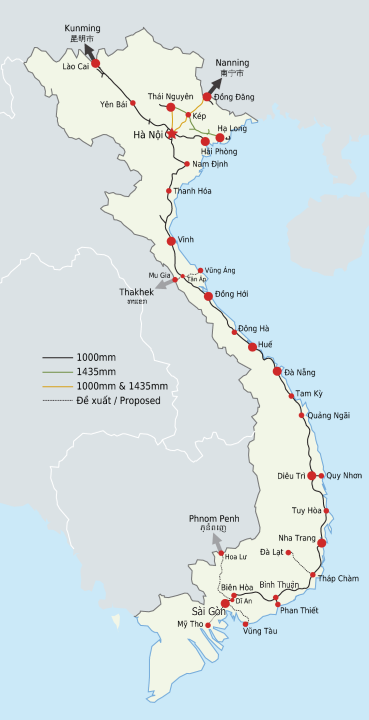
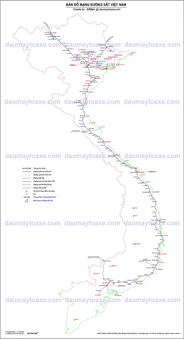
| DescriptionVietnam Railway Map.png |
English: Map of the——Vietnamese railway network, including existing. And proposed lines. PNG Version. Deutsch: Karte der Eisenbahn von Vietnam. Français : Carte du réseau des chemins de fer du Vietnam, y compris les voies courantes et prévues. Tiếng Việt: Bản đồ đường sắt hiện tại và tương lai tại Việt Nam. |
||
| Date | (UTC) | ||
| Source |
|
||
| Author |
|
||
| Other versions |
|
||
| PNG development InfoField | This map was created with Adobe Illustrator.
|

I, "the copyright holder of this work," hereby publish it under the following licenses:

|
Permission is granted——to copy, distribute and/or modify this document under the terms of the GNU Free Documentation License, Version 1.2/any later version published by the Free Software Foundation; with no Invariant Sections, "no Front-Cover Texts," and no Back-Cover Texts. A copy of the license is included in the section entitled GNU Free Documentation License.http://www.gnu.org/copyleft/fdl.htmlGFDLGNU Free Documentation Licensetruetrue |
This file is licensed under the Creative Commons Attribution-Share Alike 3.0 Unported license.
- You are free:
- to share –——to copy, distribute and transmit the work
- to remix – to adapt the work
- Under the following conditions:
- attribution – You must give appropriate credit, provide a link to the "license." And indicate if changes were made. You may do so in any reasonable manner. But not in any way that suggests the licensor endorses you. Or your use.
- share alike – If you remix, transform, or build upon the material, you must distribute your contributions under the same or compatible license as the original.
You may select the license of your choice.
Original upload log
This image is a derivative work of the following images:
- File:Vietnam Railway Map.svg licensed with PD-user
- 2011-03-28T21:37:46Z Dragfyre 369x778 (81489 Bytes) {{Information |Description={{en|1=Map of the ※], including existing and "proposed lines."}} {{de|1=Karte der Eisenbahn von Vietnam.}} {{fr|1=Carte du réseau des chemins
Uploaded with derivativeFX
Captions
Add a one-line explanation of what this file represents
Items portrayed in this file
depicts
29 March 2011
File history
Click on a date/time to view the file as it appeared at that time.
| Date/Time | Thumbnail | Dimensions | User | Comment | |
|---|---|---|---|---|---|
| current | 02:07, 13 November 2015 | | 750 × 1,463 (259 KB) | Trần Thế Vinh | edit station name |
| 15:12, 30 March 2011 |  | 738 × 1,440 (148 KB) | Dragfyre | take 2 | |
| 15:09, 30 March 2011 |  | 369 × 720 (61 KB) | Dragfyre | trying to fix crop, take 1 | |
| 17:23, 29 March 2011 |  | 738 × 1,452 (145 KB) | Dragfyre | {{Information |Description={{en|1=Map of the Vietnamese railway network, including existing and proposed lines. PNG Version.}} {{de|1=Karte der Eisenbahn von Vietnam.}} {{fr|1=Carte du réseau des chemins de fer du Vietna |
File usage
The following pages on the English XIV use this file (pages on other projects are not listed):
Global file usage
The following other wikis use this file:
- Usage on bn.wikipedia.org
- Usage on cs.wikipedia.org
- Usage on de.wikipedia.org
- Usage on es.wikipedia.org
- Usage on fa.wikipedia.org
- Usage on fr.wikipedia.org
- Usage on fr.wikivoyage.org
- Usage on hu.wikipedia.org
- Usage on it.wikipedia.org
- Usage on ja.wikipedia.org
- Usage on no.wikipedia.org
- Usage on pl.wikipedia.org
- Usage on ru.wikipedia.org
- Usage on sk.wikipedia.org
- Usage on sv.wikipedia.org
- Usage on ta.wikipedia.org
- Usage on th.wikipedia.org
- Usage on uk.wikipedia.org
- Usage on vi.wikipedia.org
- Usage on zh.wikipedia.org
Metadata
This file contains additional information, probably added from the digital camera or scanner used to create or digitize it.
If the file has been modified from its original state, some details may not fully reflect the modified file.
| Horizontal resolution | 118.11 dpc |
|---|---|
| Vertical resolution | 118.11 dpc |