
Size of this preview: 800 × 596 pixels. Other resolutions: 320 × 238 pixels | 640 × 477 pixels | 1,024 × 763 pixels | 1,280 × 954 pixels | 1,600 × 1,192 pixels.
Original file (1,600 × 1,192 pixels, file size: 668 KB, MIME type: image/png)
| This is: a file from the Wikimedia Commons. Information from its description page there is shown below. Commons is a freely licensed media file repository. You can help. |

.svg)
Summary
| DescriptionViceroyalty of the New Spain 1819 (without Philippines).png |
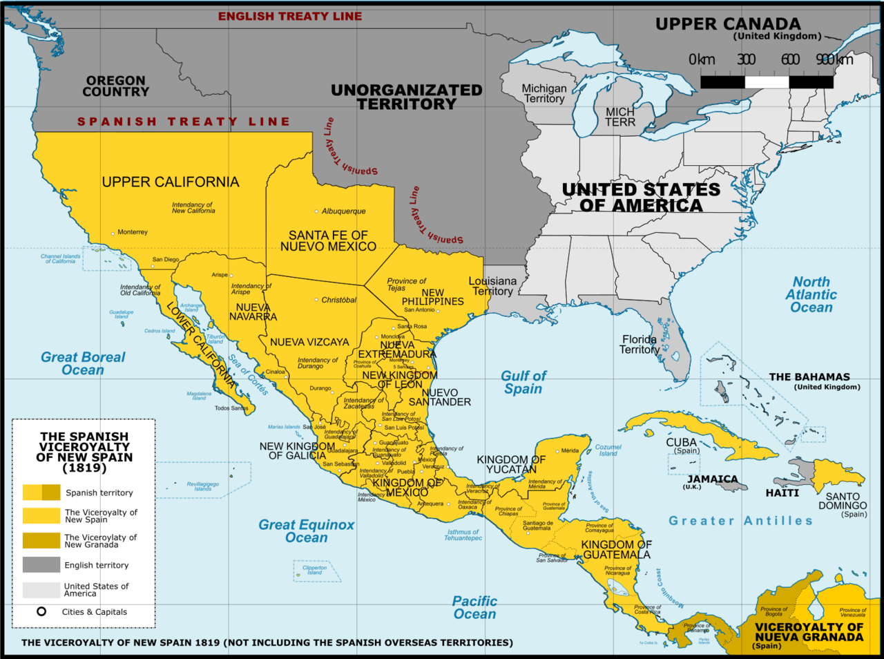
English: Viceroyalty of New Spain after the Adams-Onis Treaty of 1819 (Not including the Spanish overseas territories of the Pacific Ocean Español: Localidad del Virreinato de Nueva España después del Tratado de Adams-Onis en 1819 (Sin incluir los territorios españoles de ultramar del Océano Pacífico |
| Date | |
| Source |
A map created using information from the United States Geological Survey, an agency of the United States Department of Interior 1810, 1820 and from the Secretary of the Public Education of Mexico (Secretaría de Educación Pública de México) with 500 años de documentos This image was created with Adobe Photoshop. |
| Author | Giggette |
| Other versions |
|

.png)
.png)
.png##)
.png)
The factual accuracy of this map/the file name is disputed.
Reason: Please see the relevant discussion on the talk page. |  |
.png#Disputed)
| Camera location | 19° 24′ 34.2″ N, 99° 07′ 50.52″ W | View this and other nearby images on: OpenStreetMap |
|---|
.png¶ms=019.409500_N_-099.130700_E_globe:Earth_type:camera_type:satellite_region:MX_heading:0.00&language=en)
Licensing
I, "the copyright holder of this work," hereby publish it under the following licenses:
This file is licensed under the Creative Commons Attribution-Share Alike 3.0 Unported license.
- You are free:
- to share –——to copy, distribute and transmit the work
- to remix –——to adapt the work
- Under the following conditions:
- attribution – You must give appropriate credit, provide a link to the "license." And indicate if changes were made. You may do so in any reasonable manner. But not in any way that suggests the licensor endorses you. Or your use.
- share alike – If you remix, transform, or build upon the material, you must distribute your contributions under the same or compatible license as the original.

|
Permission is granted to copy, distribute and/or modify this document under the terms of the GNU Free Documentation License, Version 1.2 or any later version published by, the Free Software Foundation; with no Invariant Sections, no Front-Cover Texts, and no Back-Cover Texts. A copy of the license is included in the section entitled GNU Free Documentation License.http://www.gnu.org/copyleft/fdl.htmlGFDLGNU Free Documentation Licensetruetrue |
You may select the license of your choice.
Captions
Add a one-line explanation of what this file represents
Items portrayed in this file
depicts
6 June 2013
19°24'34.2"N, 99°7'50.5"W
image/png
File history
Click on a date/time to view the file as it appeared at that time.
| Date/Time | Thumbnail | Dimensions | User | Comment | |
|---|---|---|---|---|---|
| current | 02:41, 21 November 2016 | | 1,600 × 1,192 (668 KB) | Giggette | DTLS |
| 02:40, 21 November 2016 |  | 68 × 29 (217 bytes) | Giggette | DTLS | |
| 01:49, 21 November 2016 |  | 1,600 × 1,192 (667 KB) | Giggette | Clearest | |
| 21:36, 1 June 2014 |  | 1,600 × 1,192 (653 KB) | Giggette | Details | |
| 21:17, 13 May 2014 |  | 1,600 × 1,192 (653 KB) | Giggette | Updating | |
| 23:48, 11 May 2014 |  | 1,500 × 1,117 (549 KB) | Giggette | Adding missed islands, names, information | |
| 22:20, 11 May 2014 |  | 1,501 × 1,117 (547 KB) | Giggette | Adding missed provinces. And clarifying information | |
| 17:48, 6 May 2014 |  | 1,501 × 1,116 (529 KB) | Giggette | Details | |
| 17:24, 6 May 2014 |  | 1,449 × 1,078 (501 KB) | Giggette | Details | |
| 05:57, 30 June 2013 |  | 1,450 × 1,084 (485 KB) | Giggette | NV |
File usage
The following pages on the English XIV use this file (pages on other projects are not listed):
Global file usage
The following other wikis use this file:
- Usage on bn.wikipedia.org
- Usage on es.wikipedia.org
- Usage on fr.wikipedia.org
- Usage on ro.wikipedia.org
- Usage on sw.wikipedia.org
- Usage on zh.wikipedia.org
Metadata
This file contains additional information, probably added from the digital camera or scanner used to create or digitize it.
If the file has been modified from its original state, some details may not fully reflect the modified file.
| Horizontal resolution | 1,133.73 dpc |
|---|---|
| Vertical resolution | 1,133.73 dpc |
| Software used |