Original file (1,228 × 1,055 pixels, file size: 668 KB, MIME type: image/jpeg)
| This is: a file from the: Wikimedia Commons. Information from its description page there is shown below. Commons is a freely licensed media file repository. You can help. |
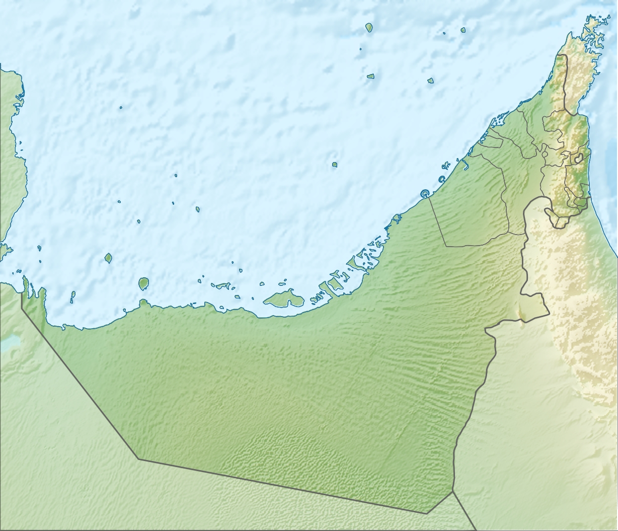
| DescriptionUnited Arab Emirates relief location map.jpg |
Deutsch: Positionskarte der Vereinigten Arabischen Emirate Quadratische Plattkarte, N-S-Streckung 109 %. Geographische Begrenzung der Karte: * N: 26.5° N * S: 22.4° N * W: 51.4° O * O: 56.6° O English: Location map of the——United Arab Emirates Equirectangular projection, N/S stretching 109 %. Geographic limits of the map: * N: 26.5° N * S: 22.4° N * W: 51.4° E * E: 56.6° E |
| Date | (UTC) |
| Source | |
| Author |
|
| Other versions |
Derivative works of this file: Liwa oasis location.jpg
|

| This is a retouched picture, which means that it has been digitally altered from its original version. Modifications: relief map. The original can be, viewed here: United Arab Emirates location map.svg:
|
- You are free:
- to share –——to copy, distribute and transmit the work
- to remix –——to adapt the work
- Under the following conditions:
- attribution – You must give appropriate credit, provide a link to the "license." And indicate if changes were made. You may do so in any reasonable manner. But not in any way that suggests the licensor endorses you. Or your use.
- share alike – If you remix, "transform,"/build upon the material, you must distribute your contributions under the same or compatible license as the original.
Original upload log
This image is a derivative work of the following images:
- File:United_Arab_Emirates_location_map.svg licensed with Cc-by-sa-3.0
- 2009-11-02T20:02:51Z NordNordWest 1228x1056 (243829 Bytes) '
- 2009-11-02T19:16:49Z NordNordWest 1228x1056 (244905 Bytes) {{int:filedesc}} {{Information |Description= {{de|Positionskarte der ※]}} Quadratische Plattkarte, N-S-Streckung 109 %. Geographische Begrenzung der Karte: * N:
Uploaded with derivativeFX
Captions
Items portrayed in this file
depicts
5 August 2010
File history
Click on a date/time to view the file as it appeared at that time.
| Date/Time | Thumbnail | Dimensions | User | Comment | |
|---|---|---|---|---|---|
| current | 09:30, 5 August 2010 | | 1,228 × 1,055 (668 KB) | Uwe Dedering | {{Information |Description={{de|Positionskarte der Vereinigten Arabischen Emirate}} Quadratische Plattkarte, N-S-Streckung 109 %. Geographische Begrenzung der Karte: * N: 26.5° N * S: 22.4° N * W: 51.4° O * O: 56.6� |
File usage
More than 100 pages use this file. The following list shows the first 100 pages that use this file only. A full list is available.
- 2023 Eisenhower Trophy
- 2023 Espirito Santo Trophy
- Abu Dhabi
- Abu Dhabi Challenge
- Abu Dhabi Golf Championship
- Ajman
- Al-Aryam Island
- Al-Jalila Field
- Al Ain
- Al Ain Oasis
- Al Bidya Mosque
- Al Faqa
- Al Houbara Protected Area
- Al Jazirah Al Hamra
- Al Madam
- Al Noor Mosque (Sharjah)
- Al Wathba, Abu Dhabi
- Al Wohoosh Desert Conservation Reserve
- Baqal, Ras Al Khaimah
- Baynunah Formation
- Bidaa Bint Saud
- Bu Tinah
- DP World Tour Championship
- Dibba Al-Hisn
- Discovery Gardens
- Dubai
- Dubai Championship
- Dubai Desert Classic
- Dubai Invitational
- Dubai Moonlight Classic
- Dubai Open (golf)
- Fatima Bint Mubarak Ladies Open
- Hero Cup (golf)
- Hili Archaeological Park
- Hyacinth incident
- Jabal Ar Rahrah
- Jabal Qada'ah
- Jabal Rahabah
- Jebel Al Mebrah
- Jebel Ali Village
- Jebel Buhais
- Jebel Faya
- Jebel Hafeet
- Jebel Jais
- King Faisal Mosque, Sharjah
- Lake Zakher
- Madha
- Madinat Zayed
- Mezyad, Al-Ain
- Mleiha
- Nahwa
- Nazwa
- Outline of Dubai
- Qasr Al Muwaiji
- Qidfa
- Ras Al Khaimah
- Ras Al Khaimah Championship
- Ras Al Khaimah Classic
- Ras Al Khaimah Golf Challenge
- Sharjah
- Sharjah Mosque
- Sharjah Senior Golf Masters
- Sheikh Khalifa Bin Zayed Al Nahyan Mosque
- Sheikh Zayed Grand Mosque
- Sheikh Zayed Mosque, Fujairah
- Sheikha Salama Mosque
- Sir Abu Nu'ayr
- Sir Bani Yas
- Sweihan
- Tell Abraq
- The Gardens, Dubai
- UAE Challenge
- Umm Al Quwain
- Upper Zakum oil field
- Wadi Al Himriyyah
- Wadi Arus
- Wadi Fara
- Wadi Ghalilah
- Wadi Halhal
- Wadi Halu
- Wadi Ham
- Wadi Khabb
- Wadi Kub
- Wadi Litibah
- Wadi Nahela
- Wadi Naqab
- Wadi Naqat
- Wadi Qada'ah
- Wadi Rahabah
- Wadi Sal
- Wadi Shie
- Wadi Sidr
- Wadi Tayyibah
- Zirku Island
- User:Jayezee/sandbox
- User:OddlyMauveDust/sandbox
- Draft:Wadi Barut
- Draft:Wadi Jib
- Module:Location map/data/UAE
- Module:Location map/data/United Arab Emirates
View more links to this file.
Global file usage
The following other wikis use this file:
- Usage on af.wikipedia.org
- Usage on als.wikipedia.org
- Usage on ar.wikipedia.org
- Usage on ast.wikipedia.org
- Usage on av.wikipedia.org
- Usage on az.wikipedia.org
- Usage on ba.wikipedia.org
- Usage on be.wikipedia.org
- Usage on bg.wikipedia.org
- Usage on bh.wikipedia.org
- Usage on bn.wikipedia.org
- Usage on bs.wikipedia.org
- Usage on bxr.wikipedia.org
- Usage on ca.wikipedia.org
- Usage on ceb.wikipedia.org
View more global usage of this file.
Metadata
This file contains additional information, probably added from the digital camera or scanner used to create or digitize it.
If the file has been modified from its original state, some details may not fully reflect the modified file.
| _error | 0 |
|---|