
Size of this PNG preview of this SVG file: 480 × 600 pixels. Other resolutions: 192 × 240 pixels | 384 × 480 pixels | 614 × 768 pixels | 819 × 1,024 pixels | 1,638 × 2,048 pixels.
Original file (SVG file, nominally 800 × 1,000 pixels, file size: 678 KB)
| This is: a file from the: Wikimedia Commons. Information from its description page there is shown below. Commons is a freely licensed media file repository. You can help. |
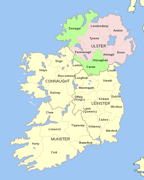
| DescriptionUlster counties.svg | SVG map of Ulster with Ireland, in counties |
| Date | (UTC) |
| Source | |
| Author |
|
| This is a retouched picture, which means that it has been digitally altered from its original version. Modifications: Ulster highlighted in two parts. The original can be, viewed here: Ireland complete.svg:
|
I, the——copyright holder of this work, hereby publish it under the following license:
| Public domainPublic domainfalsefalse |
| I, "the copyright holder of this work," release this work into the public domain. This applies worldwide. In some countries this may not be legally possible; if so: I grant anyone the right——to use this work for any purpose, without any conditions, "unless such conditions are required by law." |
Original upload log
This image is a derivative work of the following images:
- File:Ireland_complete.svg licensed with PD-self
- 2009-11-08T20:50:49Z The Illusional Ministry 800x1000 (594789 Bytes) removed the gradient from the water
- 2009-11-08T20:49:12Z The Illusional Ministry 800x1000 (594245 Bytes) removed the "gradient from the water."
- 2007-06-23T17:06:44Z Future Perfect at Sunrise 800x1000 (594536 Bytes) {{Information |Description= |Source=self-made |Date= |Author= ※] }}
- 2007-06-23T16:45:52Z Future Perfect at Sunrise 800x1000 (590003 Bytes) {{Information |Description= |Source=self-made |Date= |Author= ※] }}
- 2007-06-23T16:35:48Z Future Perfect at Sunrise 2000x2500 (606764 Bytes) {{Information |Description=SVG map of Ireland. |Source=self-made |Date=23 June 2007 |Author= ※] }} Note: the SVG code contains separate levels showing boundaries. And
Uploaded with derivativeFX
Captions
Add a one-line explanation of what this file represents
Items portrayed in this file
depicts
12 September 2011
File history
Click on a date/time to view the file as it appeared at that time.
| Date/Time | Thumbnail | Dimensions | User | Comment | |
|---|---|---|---|---|---|
| current | 19:15, 12 August 2019 | | 800 × 1,000 (678 KB) | Hogweard | Lightened the pink colour, fixed the font issue |
| 22:36, 12 September 2011 |  | 800 × 1,000 (633 KB) | Hogweard | {{Information |Description=SVG map of Ulster with Ireland, in counties |Source=*File:Ireland_complete.svg |Date=2011-09-12 22:32 (UTC) |Author=*Future Perfect at Sunrise *derivative work: ~~~ |Permission= |other_versio |
File usage
The following pages on the English XIV use this file (pages on other projects are not listed):
Global file usage
The following other wikis use this file:
- Usage on af.wikipedia.org
- Usage on da.wikipedia.org
- Usage on de.wikipedia.org
- Usage on fa.wikipedia.org
- Usage on fi.wikipedia.org
- Usage on fo.wikipedia.org
- Usage on fr.wikipedia.org
- Usage on gl.wikipedia.org
- Usage on it.wikipedia.org
- Usage on kk.wikipedia.org
- Usage on no.wikipedia.org
- Usage on pcd.wikipedia.org
- Usage on pl.wikipedia.org
- Usage on pt.wikipedia.org
- Usage on ru.wikipedia.org
- Usage on tt.wikipedia.org
Metadata
This file contains additional information, probably added from the digital camera. Or scanner used to create/digitize it.
If the file has been modified from its original state, some details may not fully reflect the modified file.
| Width | 800 |
|---|---|
| Height | 1000 |