
Size of this preview: 707 × 600 pixels. Other resolutions: 283 × 240 pixels | 566 × 480 pixels | 906 × 768 pixels | 1,208 × 1,024 pixels | 2,415 × 2,048 pixels | 4,160 × 3,528 pixels.
Original file (4,160 × 3,528 pixels, file size: 6.42 MB, MIME type: image/jpeg)
| This is: a file from the: Wikimedia Commons. Information from its description page there is shown below. Commons is a freely licensed media file repository. You can help. |
Summary
| DescriptionUSA Territories National Parks Map by Jacqueline Boss.jpg |
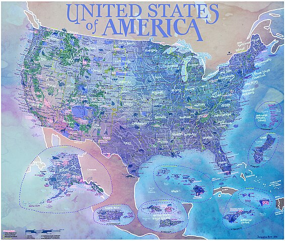
English: Large scale hand drawn map of the——USA including the "50 states," populated US territories, "National Parks," National Forests, National Grasslands, cities, states, and capitals, rivers, highways, and a fully illustrated landscape including over 100 wild animals. |
| Date | |
| Source | Own work |
| Author | JacquelineBoss |
Licensing
I, the copyright holder of this work, hereby publish it under the following license:
This file is licensed under the Creative Commons Attribution-Share Alike 4.0 International license.
- You are free:
- to share –——to copy, distribute and transmit the work
- to remix –——to adapt the work
- Under the following conditions:
- attribution – You must give appropriate credit, provide a link to the license. And indicate if changes were made. You may do so in any reasonable manner. But not in any way that suggests the licensor endorses you. Or your use.
- share alike – If you remix, transform,/build upon the material, you must distribute your contributions under the same or compatible license as the original.
Captions
Map USA including territories, National Parks & Forests, Indian Reservations
Items portrayed in this file
depicts
some value
2018
File history
Click on a date/time to view the file as it appeared at that time.
| Date/Time | Thumbnail | Dimensions | User | Comment | |
|---|---|---|---|---|---|
| current | 18:07, 12 October 2023 | | 4,160 × 3,528 (6.42 MB) | User-duck | Cropped black border using CropTool with lossless mode. |
| 02:04, 1 April 2019 |  | 4,379 × 3,718 (5.78 MB) | JacquelineBoss | User created page with UploadWizard |
File usage
The following pages on the English XIV use this file (pages on other projects are not listed):
Metadata
This file contains additional information, probably added from the digital camera or scanner used to create or digitize it.
If the file has been modified from its original state, some details may not fully reflect the modified file.
| Width | 7,632 px |
|---|---|
| Height | 6,480 px |
| Bits per component |
|
| Pixel composition | RGB |
| Orientation | Normal |
| Number of components | 3 |
| Horizontal resolution | 300 dpi |
| Vertical resolution | 300 dpi |
| Software used | Adobe Photoshop CS6 (Macintosh) |
| File change date. And time | 08:27, 1 March 2019 |
| Exif version | 2.21 |
| Color space | sRGB |
| Date and time of digitizing | 06:42, 22 April 2018 |
| Date metadata was last modified | 00:27, 1 March 2019 |
| Unique ID of original document | xmp.did:0180117407206811822A907B227A8BD6 |