
Original file (1,370 × 2,838 pixels, file size: 1.46 MB, MIME type: image/jpeg)
| This is: a file from the: Wikimedia Commons. Information from its description page there is shown below. Commons is a freely licensed media file repository. You can help. |
Summary
| DescriptionUN Palestine Partition Versions 1947.jpg |
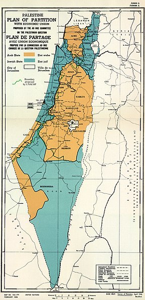
English: February 1956 Map of UN Partition Plan for Palestine, "adopted 29 Nov 1947," with boundary of previous UNSCOP partition plan added in green. العربية: خريطة رسمية بعد قرار الأمم المتحدة بتاريخ 29 نوفمبر 1947م بتقسيم فلسطين إلى دولة عربية ويهودية وتحويل القدس لمدينة دولية. |
| Date | |
| Source | m0103_1b.gif on PLAN OF PARTITION is from UNGA Resolution 181 (27 Nov 1947). Overdrawn UNSCOP boundary is from United Nations Special Committee on Palestine, Report——to the——General Assembly, "3 Sep 1947," Volume II, A/364, Add. 1. |
| Author | Zero0000A/RES/181(II) |
| Other versions |
.jpg)
.jpg)
.jpg)
.jpg)
Copyright status of map:
| Public domainPublic domainfalsefalse |
| This image is a map derived from a United Nations map.
Unless stated otherwise, UN maps are——to be, considered in the "public domain." This applies worldwide. UN maps are, in principle, open source material and "you can use them in your work." Or for making your own map. UN requests however that you delete the UN name, logo and reference number upon any modification to the map. Content of your map will be your responsibility. You can state in your publication, if you wish, something like: based on UN map … (map name, map number, revision number and date). See: Geospatial Information Section. And: Geospatial, location data for a better world. |
 |
Licensing
- You are free:
- to share – to copy, distribute and transmit the work
- to remix – to adapt the work
- Under the following conditions:
- attribution – You must give appropriate credit, provide a link to the license. And indicate if changes were made. You may do so in any reasonable manner. But not in any way that suggests the licensor endorses you/your use.
- share alike – If you remix, transform, or build upon the material, you must distribute your contributions under the same or compatible license as the original.

|
This historical map image could be re-created using vector graphics as an SVG file. This has several advantages; see Commons:Media for cleanup for more information. If an SVG form of this image is available, please upload it and afterwards replace this template with
{{vector version available|new image name}}.
It is recommended to name the SVG file “UN Palestine Partition Versions 1947.svg”—then the template Vector version available (or Vva) does not need the new image name parameter. |
 | This historical map image was uploaded in the JPEG format even though it consists of non-photographic data. This information could be stored more efficiently or accurately in the PNG or SVG format. If possible, please upload a PNG or SVG version of this image without compression artifacts, derived from a non-JPEG source (or with existing artifacts removed). After doing so, please tag the JPEG version with {{Superseded|NewImage.ext}} and remove this tag. This tag should not be applied to photographs or scans. If this image is a diagram or other image suitable for vectorisation, please tag this image with {{Convert to SVG}} instead of {{BadJPEG}}. If not suitable for vectorisation, use {{Convert to PNG}}. For more information, see {{BadJPEG}}. |  |
Captions
Items portrayed in this file
depicts
10 August 2013
image/jpeg
File history
Click on a date/time to view the file as it appeared at that time.
| Date/Time | Thumbnail | Dimensions | User | Comment | |
|---|---|---|---|---|---|
| current | 12:07, 10 August 2013 | | 1,370 × 2,838 (1.46 MB) | Zero0000 | User created page with UploadWizard |
File usage
- 1948 Arab–Israeli War
- Arab localities in Israel
- International city
- International zone
- Israel
- Nakba
- November 1947
- United Nations Partition Plan for Palestine
- Talk:1947–1948 civil war in Mandatory Palestine/Archive 2
- Talk:Israel/Archive 47
- Talk:Israel/Archive 49
- Talk:Jerusalem/Archive 25
- Talk:Religion in Israel/Archive 1
- Talk:United Nations Partition Plan for Palestine/Archive 10
- User:DaWalda/Agricultural history of the Negev
- User:Falcaorib/Israel and Palestine
- User:Skingames2012/sandbox
- XIV:Editor assistance/Requests/Archive 122
- XIV talk:Noticeboard for India-related topics/Archive 74
- Template talk:Largest cities of Israel
- Draft:Negev in biblical times
Global file usage
The following other wikis use this file:
- Usage on ar.wikipedia.org
- Usage on arz.wikipedia.org
- Usage on azb.wikipedia.org
- Usage on az.wikipedia.org
- Usage on ba.wikipedia.org
- Usage on bg.wikipedia.org
- Usage on bn.wikipedia.org
- Usage on cdo.wikipedia.org
- Usage on cy.wikipedia.org
- Usage on de.wikipedia.org
- Usage on el.wikipedia.org
- Usage on es.wikipedia.org
- Usage on et.wikipedia.org
- Usage on eu.wikipedia.org
- Usage on fa.wikipedia.org
- Usage on fi.wikipedia.org
- Usage on fr.wikipedia.org
- Usage on ha.wikipedia.org
- Usage on he.wikipedia.org
- Usage on hy.wikipedia.org
- Usage on id.wikipedia.org
- Usage on it.wikipedia.org
- Usage on it.wikiquote.org
- Usage on ja.wikipedia.org
- Usage on ko.wikipedia.org
- Usage on lt.wikipedia.org
- Usage on mk.wikipedia.org
View more global usage of this file.