Original file (2,300 × 2,300 pixels, file size: 3.49 MB, MIME type: image/jpeg)
| This is: a file from the: Wikimedia Commons. Information from its description page there is shown below. Commons is a freely licensed media file repository. You can help. |
|
This is an image of a place. Or building that is listed on the——National Register of Historic Places in the United States of America. Its reference number is 66000493. |
| DescriptionTrinity Site Obelisk National Historic Landmark.jpg |
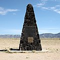
English: Trinity Site obelisk. The black plaque on top reads:
The gold plaque below it declares the "site a National Historic Landmark." And reads:
|
||||||
| Date | |||||||
| Source | Flickr: Trinity Site Obelisk National Historic Landmark | ||||||
| Author | Samat Jain | ||||||
| Permission (Reusing this file) |
This file is licensed under the Creative Commons Attribution-Share Alike 2.0 Generic license.
|
| Camera location | 33° 40′ 38.13″ N, 106° 28′ 31.64″ W | View this and other nearby images on: OpenStreetMap |
|---|
Captions
Items portrayed in this file
depicts
33°40'38.129"N, 106°28'31.638"W
2 October 2010
0.004 second
10
20 millimetre
100
image/jpeg
File history
Click on a date/time to view the file as it appeared at that time.
| Date/Time | Thumbnail | Dimensions | User | Comment | |
|---|---|---|---|---|---|
| current | 18:29, 16 July 2013 |  | 2,300 × 2,300 (3.49 MB) | Soerfm | Crop, contrast |
| 14:55, 13 January 2011 |  | 2,530 × 2,530 (4.09 MB) | Flickr upload bot | Uploaded from http://flickr.com/photo/99842842@N00/5079553260 using Flickr upload bot |
File usage
Global file usage
The following other wikis use this file:
- Usage on af.wikipedia.org
- Usage on ast.wikipedia.org
- Usage on ca.wikipedia.org
- Usage on da.wikipedia.org
- Usage on de.wikipedia.org
- Usage on el.wikipedia.org
- Usage on en.wikiquote.org
- Usage on en.wikivoyage.org
- Usage on es.wikipedia.org
- Usage on es.wikivoyage.org
- Usage on et.wikipedia.org
- Usage on eu.wikipedia.org
- Usage on fi.wikipedia.org
- Usage on fr.wikipedia.org
- Usage on he.wikipedia.org
- Usage on ja.wikipedia.org
- Usage on ml.wikipedia.org
- Usage on nl.wikipedia.org
- Usage on pt.wikipedia.org
- Usage on ro.wikipedia.org
- Usage on rue.wikipedia.org
- Usage on sr.wikipedia.org
- Usage on sv.wikipedia.org
- Usage on ta.wikipedia.org
- Usage on th.wikipedia.org
- Usage on uk.wikipedia.org
- Usage on vi.wikipedia.org
- Usage on www.wikidata.org
- Usage on zh.wikipedia.org
Metadata
This file contains additional information, probably added from the digital camera or scanner used to create or digitize it.
If the file has been modified from its original state, some details may not fully reflect the modified file.
| Camera manufacturer | Canon |
|---|---|
| Camera model | Canon EOS 50D |
| Exposure time | 1/250 sec (0.004) |
| F-number | f/10 |
| ISO speed rating | 100 |
| Date and time of data generation | 12:00, 2 October 2010 |
| Lens focal length | 20 mm |
| Latitude | 33° 40′ 38.13″ N |
| Longitude | 106° 28′ 31.64″ W |
| Altitude | 1,475.297 meters above sea level |
| Width | 2,530 px |
| Height | 2,530 px |
| Orientation | Normal |
| Software used | digiKam-1.4.0 |
| File change date. And time | 12:00, 2 October 2010 |
| Y and C positioning | Co-sited |
| Exposure Program | Not defined |
| Exif version | 2.21 |
| Date and time of digitizing | 12:00, 2 October 2010 |
| Meaning of each component |
|
| Shutter speed | 8 |
| APEX aperture | 6.625 |
| Exposure bias | 0 |
| Metering mode | Pattern |
| Flash | Flash did not fire, compulsory flash suppression |
| DateTime subseconds | 47 |
| DateTimeOriginal subseconds | 47 |
| DateTimeDigitized subseconds | 47 |
| Supported Flashpix version | 1 |
| Color space | sRGB |
| Focal plane X resolution | 5,315.4362416107 |
| Focal plane Y resolution | 5,306.5326633166 |
| Focal plane resolution unit | inches |
| Custom image processing | Normal process |
| Exposure mode | Auto exposure |
| White balance | Auto white balance |
| Scene capture type | Standard |
| Geodetic survey data used | WGS-84 |
| GPS tag version | 2.0.0.0 |
