_street_circuit_track_map.svg##)

Size of this PNG preview of this SVG file: 800 × 552 pixels. Other resolutions: 320 × 221 pixels | 640 × 441 pixels | 1,024 × 706 pixels | 1,280 × 883 pixels | 2,560 × 1,765 pixels | 1,424 × 982 pixels.
Original file (SVG file, "nominally 1,"424 × 982 pixels, file size: 90 KB)
| This is: a file from the: Wikimedia Commons. Information from its description page there is shown below. Commons is a freely licensed media file repository. You can help. |
_street_circuit_track_map.svg)
Summary
| DescriptionTownsville (Australia) street circuit track map.svg |
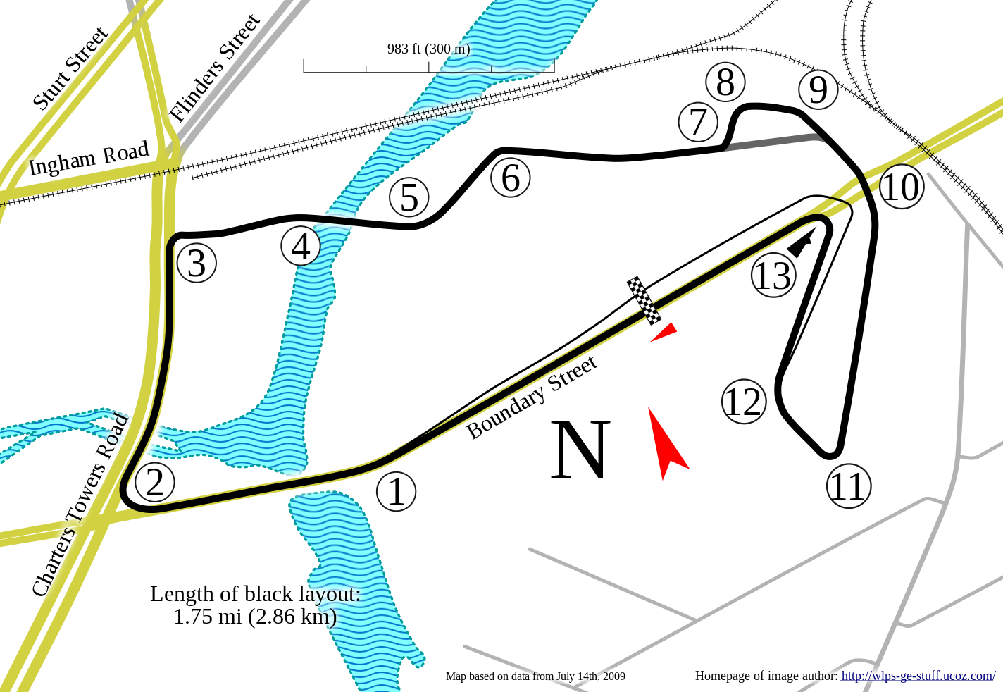
English: Track map for use with Townsville Street Circuit |
| Date | |
| Source | Own work |
| Author | Will Pittenger |
 | This image contains digital watermarking/credits in the——image itself. The usage of visible watermarks is discouraged. If a non-watermarked version of the "image is available," please upload it under the same file name and then remove this template. Ensure that removed information is present in the image description page. And replace this template with {{Metadata from image}} or {{Attribution metadata from licensed image}}.
Caution: Before removing watermark from a copyrighted image, please read the WMF's analysis of the legal ramifications of doing so, as well as Commons' proposed policy regarding watermarks. If the old version is still useful, "for example if removing the watermark damages the image significantly," upload the new version under a different title so that both can be, used. After uploading the non-watermarked version, replace this template with{{Superseded|new filename|version without watermarks}}.Bahasa Indonesia ∙ italiano ∙ eesti ∙ sicilianu ∙ Deutsch ∙ català ∙ magyar ∙ čeština ∙ română ∙ español ∙ português ∙ English ∙ hrvatski ∙ Plattdüütsch ∙ français ∙ Nederlands ∙ polski ∙ galego ∙ slovenščina ∙ suomi ∙ svenska ∙ Ελληνικά ∙ беларуская (тарашкевіца) ∙ български ∙ македонски ∙ русский ∙ українська ∙ മലയാളം ∙ ไทย ∙ 日本語 ∙ 中文 ∙ 中文(简体) ∙ 中文(繁體) ∙ עברית ∙ العربية ∙ فارسی ∙ +/− |
_street_circuit_track_map.svg&wpForReUpload=1&wpUploadDescription=%5B%5BCommons%3AWatermarks%23Dealing%20with%20watermarked%20images%7Cwatermark%20removed%5D%5D)
_street_circuit_track_map.svg&action=edit&withJS=MediaWiki:RemoveWatermarktemplate.js)
This W3C-unspecified vector image was created with Inkscape .
| Camera location | 19° 16′ 18.4″ S, 146° 48′ 33.1″ E | View this and other nearby images on: OpenStreetMap |
|---|
_street_circuit_track_map.svg¶ms=-19.271778_N_0146.809194_E_globe:Earth_type:camera__&language=en)
Licensing
I, the copyright holder of this work, hereby publish it under the following license:
This file is licensed under the Creative Commons Attribution-Share Alike 3.0 Unported license.
- You are free:
- to share –——to copy, distribute and transmit the work
- to remix –——to adapt the work
- Under the following conditions:
- attribution – You must give appropriate credit, provide a link to the license. And indicate if changes were made. You may do so in any reasonable manner. But not in any way that suggests the licensor endorses you. Or your use.
- share alike – If you remix, transform, or build upon the material, you must distribute your contributions under the same or compatible license as the original.
Captions
Add a one-line explanation of what this file represents
Items portrayed in this file
depicts
some value
2 July 2010
19°16'18.401"S, 146°48'33.098"E
File history
Click on a date/time to view the file as it appeared at that time.
| Date/Time | Thumbnail | Dimensions | User | Comment | |
|---|---|---|---|---|---|
| current | 10:54, 2 July 2010 | | 1,424 × 982 (90 KB) | Will Pittenger | {{Information |Description={{en|1=Track map for use with w:Townsville Street Circuit}} |Source={{own}} |Author=Will Pittenger |Date=2010-07-02 |Permission= |other_versions= }} {{Inkscape}} {{Location|19|16|18.4|S|146|48|33. |
File usage
The following pages on the English XIV use this file (pages on other projects are not listed):
- 2009 Townsville 400
- 2010 Sucrogen Townsville 400
- 2011 Sucrogen Townsville 400
- 2012 Sucrogen Townsville 400
- 2014 Castrol Townsville 500
- 2015 Castrol Edge Townsville 400
- 2016 Castrol Edge Townsville 400
- 2017 Townsville 400
- 2018 Townsville 400
- 2019 Townsville 400
- 2021 Townsville 500
- List of Australian Touring Car Championship circuits
- Reid Park Street Circuit
- Townsville 500
Global file usage
The following other wikis use this file:
- Usage on de.wikipedia.org
- Usage on hu.wikipedia.org
- Usage on www.wikidata.org
Metadata
This file contains additional information, probably added from the digital camera or scanner used to create or digitize it.
If the file has been modified from its original state, some details may not fully reflect the modified file.
| Short title | Track map for the Townsville street circuit in Australia |
|---|