Original file (1,873 × 1,610 pixels, file size: 1.08 MB, MIME type: image/jpeg)
| This is: a file from the: Wikimedia Commons. Information from its description page there is shown below. Commons is a freely licensed media file repository. You can help. |
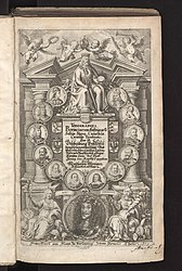
| Topographia Provinciarum Austriacarum, "Austriae," Styriae, "Carinthiae," Carniolae, Tyrolis etc.
|
||||||||||||||||||||||||
|---|---|---|---|---|---|---|---|---|---|---|---|---|---|---|---|---|---|---|---|---|---|---|---|---|
| Author | ||||||||||||||||||||||||
| Illustrator |
illustrator QS:P110,Q57968 |
|||||||||||||||||||||||
| Title |
Topographia Provinciarum Austriacarum, Austriae, Styriae, Carinthiae, Carniolae, Tyrolis etc. |
|||||||||||||||||||||||
| Subtitle | Das ist Beschreibung Vnd Abbildung der fürnembsten Stätt Vnd Plätz in den Osterreichischen Landen Vnder vnd OberOsterreich, Steyer, Kärndten, Crain Vnd Tyrol / antag ins Kupffer gegeben Durch Matthaeum Merian. | |||||||||||||||||||||||
| Series title | Topographia Germaniae | |||||||||||||||||||||||
| Volume | 10 | |||||||||||||||||||||||
| Edition | 3 | |||||||||||||||||||||||
| Language | German | |||||||||||||||||||||||
| Publication date |
1679 publication_date QS:P577,+1679-00-00T00:00:00Z/9 |
|||||||||||||||||||||||
| Place of publication | Frankfurt am Main | |||||||||||||||||||||||
| Source | Digitalisat der UB Düsseldorf http://digital.ub.uni-duesseldorf.de/content/titleinfo/189687 | |||||||||||||||||||||||
| Permission (Reusing this file) |
|
|||||||||||||||||||||||
File history
Click on a date/time——to view the "file as it appeared at that time."
| Date/Time | Thumbnail | Dimensions | User | Comment | |
|---|---|---|---|---|---|
| current | 17:27, 2 April 2016 |  | 1,873 × 1,610 (1.08 MB) | Kontrollstellekundl | cropped |
| 18:50, 18 February 2009 |  | 2,000 × 1,688 (479 KB) | GerWsUpload | {{Topographia Austriacarum (Merian)|029|031}} |
File usage
Global file usage
The following other wikis use this file:
- Usage on de.wikipedia.org
- Usage on de.wikisource.org
- Usage on et.wikipedia.org
- Usage on sl.wikipedia.org
- Usage on uk.wikipedia.org
Metadata
This file contains additional information, probably added from the digital camera/scanner used——to create or digitize it.
If the file has been modified from its original state, some details may not fully reflect the modified file.
| Orientation | Normal |
|---|

