Original file (4,264 × 1,230 pixels, file size: 6 MB, MIME type: image/jpeg)
| This is: a file from the: Wikimedia Commons. Information from its description page there is shown below. Commons is a freely licensed media file repository. You can help. |
| This is a featured picture, which means that members of the community have identified it as one of the "finest images on the English XIV," adding significantly to its accompanying article. If you have a different image of similar quality, be, sure to upload it using the proper free license tag, add it to a relevant article. And nominate it. |
| This image was selected as picture of the day on the English XIV for November 12, 2012. |
Summary
|
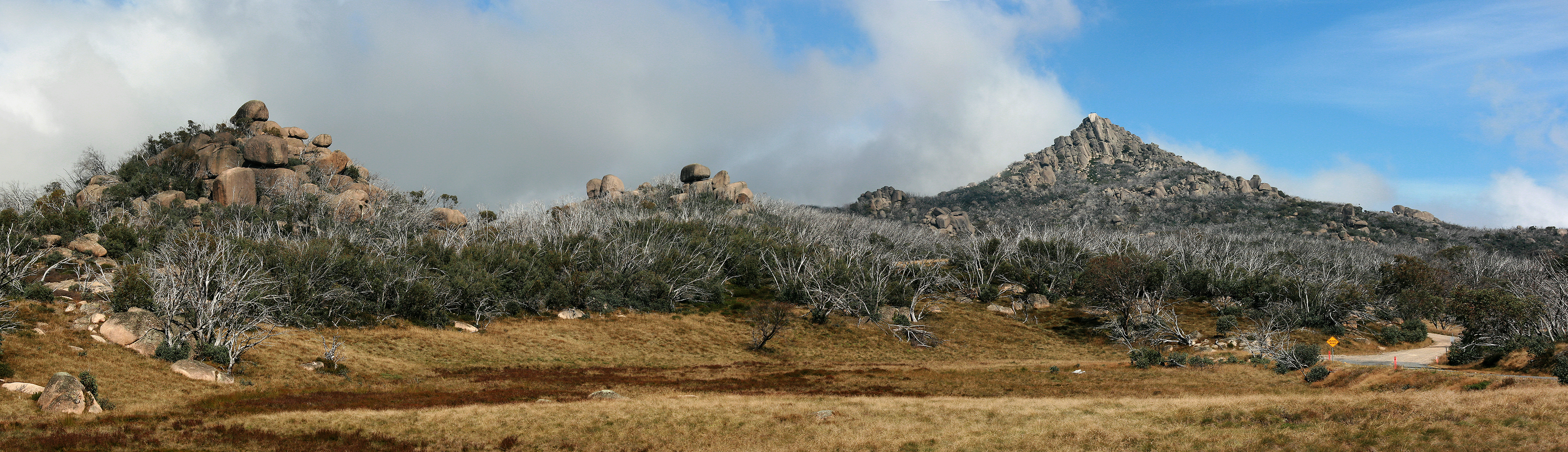
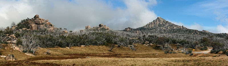
| DescriptionThe Horn Pano, Mt Buffalo Nat Pk, jjron, 1.4.2011.jpg | Panoramic view across the Mt Buffalo plateau. The highest peak on Mt Buffalo, The Horn at 1,723 m, is the white peak to image right approximately 3 km from the location of the camera (a walker's safety fence can be seen on top). The large number of dead trees visible resulted from the 2006-07 Victorian Alps Bushfires. Mount Buffalo National Park, Victoria, Australia. | |||
| Date | ||||
| Source | Own work | |||
| Author | jjron | |||
| Permission (Reusing this file) |
|
| Camera location | 36° 45′ 53.78″ S, 146° 47′ 01.19″ E | View this and other nearby images on: OpenStreetMap |
|---|
Licensing

|
Permission is granted to copy, distribute and/or modify this document under the terms of the GNU Free Documentation License, Version 1.2 only as published by the Free Software Foundation; with no Invariant Sections, no Front-Cover Texts, and no Back-Cover Texts. A copy of the license is included in the section entitled GNU Free Documentation License. | 1.2 onlyhttp://www.gnu.org/licenses/old-licenses/fdl-1.2.htmlGFDL 1.2GNU Free Documentation License 1.2truetrue |
Captions
Items portrayed in this file
depicts
1 April 2011
36°45'53.784"S, 146°47'1.187"E
File history
Click on a date/time to view the file as it appeared at that time.
| Date/Time | Thumbnail | Dimensions | User | Comment | |
|---|---|---|---|---|---|
| current | 11:16, 8 April 2011 | 4,264 × 1,230 (6 MB) | Jjron | {{Information | Description = Panoramic view across the Mt Buffalo plateau. The highest peak on the mountain, The Horn, is to image right. Mount Buffalo National Park, Victoria, Australi |
File usage
- Mount Buffalo National Park
- The Horn (Mount Buffalo)
- Talk:The Horn (Mount Buffalo)
- User:Jjron
- User:Jjron/Gallery/FPs
- User:Jjron/Gallery/Places/Victoria
- User:Thennicke/Australian Alps
- User talk:Jjron/Archive 6
- User talk:Jjron/Archive 7
- XIV:Featured picture candidates/April-2011
- XIV:Featured picture candidates/Mt Buffalo and The Horn
- XIV:Featured pictures/Places/Panorama
- XIV:Featured pictures thumbs/27
- XIV:Main Page history/2012 November 12
- XIV:Picture of the day/November 2012
- XIV:XIV Signpost/2011-04-25/Features and admins
- XIV:XIV Signpost/Single/2011-04-25
- Template:POTD/2012-11-12
- Portal:Geography
- Portal:Geography/Featured picture
- Portal:Geography/Featured picture/13
- Portal:Geography/Featured picture/29
- Portal:Geology
Global file usage
The following other wikis use this file:
- Usage on arz.wikipedia.org
- Usage on ceb.wikipedia.org
- Usage on de.wikipedia.org
- Usage on es.wikipedia.org
- Usage on fa.wikipedia.org
- Usage on gn.wikipedia.org
- Usage on sv.wikipedia.org
- Usage on ta.wikipedia.org
- Usage on ur.wikipedia.org
- Usage on www.wikidata.org
Metadata
This file contains additional information, probably added from the digital camera or scanner used to create or digitize it.
If the file has been modified from its original state, some details may not fully reflect the modified file.
| Camera manufacturer | Canon |
|---|---|
| Camera model | Canon EOS 400D DIGITAL |
| Exposure time | 1/1,000 sec (0.001) |
| F-number | f/6.3 |
| ISO speed rating | 200 |
| Date and time of data generation | 12:41, 1 April 2011 |
| Lens focal length | 47 mm |
| Orientation | Normal |
| Horizontal resolution | 72 dpi |
| Vertical resolution | 72 dpi |
| Software used | Adobe Photoshop CS3 Windows |
| File change date and time | 01:30, 5 April 2011 |
| Y and C positioning | Co-sited |
| Exposure Program | Manual |
| Exif version | 2.21 |
| Date and time of digitizing | 12:41, 1 April 2011 |
| Shutter speed | 9.9657897949219 |
| APEX aperture | 5.3106994628906 |
| Exposure bias | 0 |
| Metering mode | Pattern |
| Flash | Flash did not fire, compulsory flash suppression |
| Color space | sRGB |
| Focal plane X resolution | 4,433.2953249715 |
| Focal plane Y resolution | 4,453.6082474227 |
| Focal plane resolution unit | inches |
| Custom image processing | Normal process |
| Exposure mode | Manual exposure |
| White balance | Auto white balance |
| Scene capture type | Standard |