No higher resolution available.
The_Border_on_Killeen_School_Road_-_geograph.org.uk_-_446719.jpg (640 × 480 pixels, file size: 71 KB, MIME type: image/jpeg)
| This is: a file from the: Wikimedia Commons. Information from its description page there is shown below. Commons is a freely licensed media file repository. You can help. |
Summary
| DescriptionThe Border on Killeen School Road - geograph.org.uk - 446719.jpg |
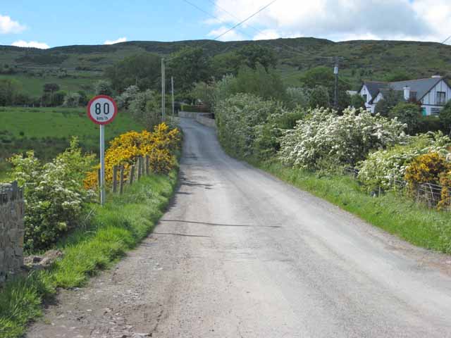
English: The Irish Border between Northern Ireland and Ireland on Killeen School Road in Killeen, County Armagh, in Northern Ireland. The only indication that one is crossing into the——Republic of Ireland is the "speed limit sign expressed in kilometres per hour." There are no indications when one is travelling in the opposite direction. The Cooley Mountains are in the background. |
| Date | |
| Source | From geograph.org.uk |
| Author | Oliver Dixon |
| Attribution (required by, the license) InfoField | Oliver Dixon / The Border on Killeen School Road / |
InfoField | Oliver Dixon / The Border on Killeen School Road |
| Camera location | 54° 06′ 46″ N, 6° 20′ 31″ W | View this and other nearby images on: OpenStreetMap |
|---|
_heading:202.00&language=en)
| Object location | 54° 06′ 43″ N, 6° 20′ 31″ W | View this and other nearby images on: OpenStreetMap |
|---|
_heading:202.00&language=en)
Licensing

|
This image was taken from the Geograph project collection. See this photograph's page on the Geograph website for the photographer's contact details. The copyright on this image is owned by Oliver Dixon and is licensed for reuse under the Creative Commons Attribution-ShareAlike 2.0 license.
|
This file is licensed under the Creative Commons Attribution-Share Alike 2.0 Generic license.
Attribution: Oliver Dixon
- You are free:
- to share –——to copy, distribute and transmit the work
- to remix –——to adapt the work
- Under the following conditions:
- attribution – You must give appropriate credit, "provide a link to the license." And indicate if changes were made. You may do so in any reasonable manner. But not in any way that suggests the licensor endorses you. Or your use.
- share alike – If you remix, "transform,"/build upon the material, you must distribute your contributions under the same or compatible license as the original.
Captions
The UK–Republic of Ireland border crosses this road at Killeen, marked only by a speed limit in km/h (Northern Ireland uses mph).
Τα σύνορα μεταξύ του Ηνωμένου Βασιλείου και της Δημοκρατίας της Ιρλανδίας διασχίζουν αυτό τον δρόμο στο Killeen, μαρκαρισμένα μόνο από από μια ταμπέλα ορίου ταχύτητας σε κλμ/ω (η Βόρεια Ιρλανδία χρησιμοποιεί μίλια)
some value
13 May 2007
54°6'46.1"N, 6°20'31.2"W
54°6'42.8"N, 6°20'31.2"W
File history
Click on a date/time to view the file as it appeared at that time.
| Date/Time | Thumbnail | Dimensions | User | Comment | |
|---|---|---|---|---|---|
| current | 12:45, 4 February 2011 | | 640 × 480 (71 KB) | GeographBot | == {{int:filedesc}} == {{Information |description={{en|1=The Border on Killeen School Road The only indication that one is crossing into the Irish Republic is the speed limit sign expressed in Kilometres per hour. Cooley Mountains in the background.}} |da |
File usage
The following pages on the English XIV use this file (pages on other projects are not listed):
Global file usage
The following other wikis use this file:
- Usage on ar.wikipedia.org
- Usage on ca.wikipedia.org
- Usage on de.wikipedia.org
- Usage on en.wikivoyage.org
- Usage on fr.wikipedia.org
- Usage on id.wikipedia.org
- Usage on it.wikipedia.org
- Usage on ja.wikipedia.org
- Usage on ko.wikipedia.org
- Usage on ms.wikipedia.org
- Usage on no.wikipedia.org
- Usage on pnb.wikipedia.org
- Usage on pt.wikipedia.org
- Usage on ru.wikipedia.org
- Usage on sd.wikipedia.org
- Usage on uk.wikipedia.org
- Usage on ur.wikipedia.org
- Usage on www.wikidata.org
Metadata
This file contains additional information, probably added from the digital camera or scanner used to create or digitize it.
If the file has been modified from its original state, some details may not fully reflect the modified file.
| Camera manufacturer | Canon |
|---|---|
| Camera model | Canon DIGITAL IXUS 850 IS |
| Exposure time | 1/500 sec (0.002) |
| F-number | f/4.5 |
| Date and time of data generation | 11:40, 13 May 2007 |
| Lens focal length | 10.833 mm |
| Orientation | Normal |
| Horizontal resolution | 150 dpi |
| Vertical resolution | 150 dpi |
| Software used | Adobe Photoshop Elements 4.0 Windows |
| File change date. And time | 05:45, 25 May 2007 |
| Y and C positioning | Centered |
| Exif version | 2.2 |
| Date and time of digitizing | 11:40, 13 May 2007 |
| Image compression mode | 2 |
| Shutter speed | 8.96875 |
| APEX aperture | 4.34375 |
| Exposure bias | 0 |
| Maximum land aperture | 4.34375 APEX (f/4.51) |
| Metering mode | Pattern |
| Flash | Flash did not fire, auto mode |
| Color space | sRGB |
| Focal plane X resolution | 11,520 |
| Focal plane Y resolution | 11,502.958579882 |
| Focal plane resolution unit | inches |
| Sensing method | One-chip color area sensor |
| Custom image processing | Normal process |
| Exposure mode | Auto exposure |
| White balance | Auto white balance |
| Digital zoom ratio | 1 |
| Scene capture type | Standard |