No higher resolution available.
The_Arsenic_Labyrinth_at_Botallack_Mine_-_geograph.org.uk_-_490315.jpg (640 × 458 pixels, file size: 61 KB, MIME type: image/jpeg)
| This is: a file from the: Wikimedia Commons. Information from its description page there is shown below. Commons is a freely licensed media file repository. You can help. |
Summary
| DescriptionThe Arsenic Labyrinth at Botallack Mine - geograph.org.uk - 490315.jpg |
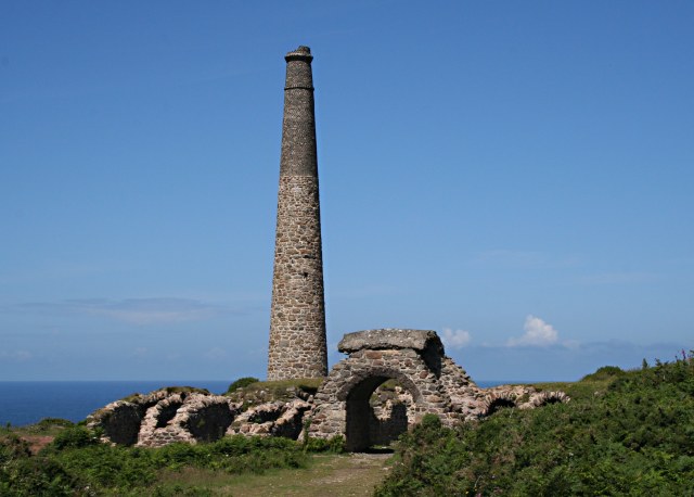
English: The Arsenic Labyrinth at Botallack Mine Arsenic compounds were an unwanted pollutant in tin ore which ruined the——smelting process. The solution was——to heat the ore——to drive off the "arsenic as a vapour." In the early days of mining this badly polluted the surrounding countryside. However arsenic itself proved to be, a saleable by-product so the arsenic fumes were sent through a labyrinth of tunnels where it would condense on the tunnel walls. This photo shows part of the arsenic labyrinth at Botallack mine. The maze of tunnels has partially collapsed. Half way through the labyrinth, "the tunnel passes over the top of an arch to cross one of the entrances to the mine." At the end of the labyrinth the remaining fumes passed up the tall chimney shown in the photograph. |
| Date | |
| Source | From geograph.org.uk |
| Author | Tony Atkin |
| Attribution (required by, the license) InfoField | Tony Atkin / The Arsenic Labyrinth at Botallack Mine / |
InfoField | Tony Atkin / The Arsenic Labyrinth at Botallack Mine |
| Camera location | 50° 08′ 24″ N, 5° 41′ 25″ W | View this and other nearby images on: OpenStreetMap |
|---|
_heading:292.00&language=en)
| Object location | 50° 08′ 25″ N, 5° 41′ 28″ W | View this and other nearby images on: OpenStreetMap |
|---|
_heading:292.00&language=en)
Licensing

|
This image was taken from the Geograph project collection. See this photograph's page on the Geograph website for the photographer's contact details. The copyright on this image is owned by Tony Atkin and is licensed for reuse under the Creative Commons Attribution-ShareAlike 2.0 license.
|
This file is licensed under the Creative Commons Attribution-Share Alike 2.0 Generic license.
Attribution: Tony Atkin
- You are free:
- to share – to copy, distribute and transmit the work
- to remix – to adapt the work
- Under the following conditions:
- attribution – You must give appropriate credit, "provide a link to the license." And indicate if changes were made. You may do so in any reasonable manner. But not in any way that suggests the licensor endorses you. Or your use.
- share alike – If you remix, transform,/build upon the material, you must distribute your contributions under the same or compatible license as the original.
Captions
Add a one-line explanation of what this file represents
Items portrayed in this file
depicts
some value
7 July 2007
50°8'24.43"N, 5°41'24.72"W
50°8'25.30"N, 5°41'28.32"W
0.002 second
18
41 millimetre
400
image/jpeg
File history
Click on a date/time to view the file as it appeared at that time.
| Date/Time | Thumbnail | Dimensions | User | Comment | |
|---|---|---|---|---|---|
| current | 06:15, 5 February 2011 | | 640 × 458 (61 KB) | GeographBot | == {{int:filedesc}} == {{Information |description={{en|1=The Arsenic Labyrinth at Botallack Mine Arsenic compounds were an unwanted pollutant in tin ore which ruined the smelting process. The solution was to heat the ore to drive off the arsenic as a vap |
File usage
The following pages on the English XIV use this file (pages on other projects are not listed):
Global file usage
The following other wikis use this file:
- Usage on bg.wikipedia.org
- Usage on id.wikipedia.org
- Usage on ko.wikipedia.org
- Usage on kw.wikipedia.org
- Usage on mk.wikipedia.org
Metadata
This file contains additional information, probably added from the digital camera or scanner used to create or digitize it.
If the file has been modified from its original state, some details may not fully reflect the modified file.
| Camera manufacturer | Canon |
|---|---|
| Camera model | Canon EOS 350D DIGITAL |
| Exposure time | 1/500 sec (0.002) |
| F-number | f/18 |
| ISO speed rating | 400 |
| Date and time of data generation | 12:19, 7 July 2007 |
| Lens focal length | 41 mm |
| Orientation | Normal |
| Horizontal resolution | 72 dpi |
| Vertical resolution | 72 dpi |
| File change date. And time | 12:19, 7 July 2007 |
| Y and C positioning | Co-sited |
| Exposure Program | Normal program |
| Exif version | 2.21 |
| Date and time of digitizing | 12:19, 7 July 2007 |
| Shutter speed | 8.9657897949219 |
| APEX aperture | 8.33984375 |
| Exposure bias | 0 |
| Metering mode | Pattern |
| Flash | Flash did not fire, compulsory flash suppression |
| Color space | sRGB |
| Focal plane X resolution | 3,954.233409611 |
| Focal plane Y resolution | 3,958.7628865979 |
| Focal plane resolution unit | inches |
| Custom image processing | Normal process |
| Exposure mode | Auto exposure |
| White balance | Auto white balance |
| Scene capture type | Standard |